Sainte-Colombe, Hautes-Alpes
| Sainte-Colombe | |
|---|---|
| Commune | |
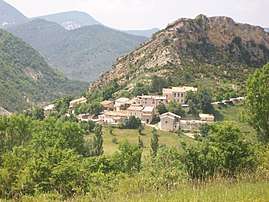 A general view of the village of Sainte-Colombe | |
 Sainte-Colombe Location within Provence-A.-C.d'A. region  Sainte-Colombe | |
| Coordinates: 44°17′08″N 5°40′10″E / 44.2856°N 5.6694°ECoordinates: 44°17′08″N 5°40′10″E / 44.2856°N 5.6694°E | |
| Country | France |
| Region | Provence-Alpes-Côte d'Azur |
| Department | Hautes-Alpes |
| Arrondissement | Gap |
| Canton | Serres |
| Intercommunality | Baronnies |
| Government | |
| • Mayor (2008–2014) | René Almeras |
| Area1 | 17.18 km2 (6.63 sq mi) |
| Population (2008)2 | 53 |
| • Density | 3.1/km2 (8.0/sq mi) |
| Time zone | UTC+1 (CET) |
| • Summer (DST) | UTC+2 (CEST) |
| INSEE/Postal code | 05135 /05700 |
| Elevation |
715–1,360 m (2,346–4,462 ft) (avg. 920 m or 3,020 ft) |
|
1 French Land Register data, which excludes lakes, ponds, glaciers > 1 km2 (0.386 sq mi or 247 acres) and river estuaries. 2 Population without double counting: residents of multiple communes (e.g., students and military personnel) only counted once. | |
Sainte-Colombe is a commune in the Hautes-Alpes department in southeastern France. It is surrounded by mountains.
Population
| Historical population | ||
|---|---|---|
| Year | Pop. | ±% |
| 1962 | 37 | — |
| 1968 | 56 | +51.4% |
| 1975 | 51 | −8.9% |
| 1982 | 49 | −3.9% |
| 1990 | 43 | −12.2% |
| 1999 | 50 | +16.3% |
| 2008 | 53 | +6.0% |
See also
References
| Wikimedia Commons has media related to Sainte-Colombe, Hautes-Alpes. |
This article is issued from
Wikipedia.
The text is licensed under Creative Commons - Attribution - Sharealike.
Additional terms may apply for the media files.