La Beaume
| La Beaume | |
|---|---|
| Commune | |
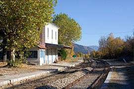 The La Beaume railway station, on the line between Livron and Aspres-sur-Buëch | |
 La Beaume Location within Provence-A.-C.d'A. region  La Beaume | |
| Coordinates: 44°33′11″N 5°38′15″E / 44.5531°N 5.6375°ECoordinates: 44°33′11″N 5°38′15″E / 44.5531°N 5.6375°E | |
| Country | France |
| Region | Provence-Alpes-Côte d'Azur |
| Department | Hautes-Alpes |
| Arrondissement | Gap |
| Canton | Serres |
| Intercommunality | Haut Buëch |
| Government | |
| • Mayor (2001–2008) | Serge Rigaud |
| Area1 | 29.64 km2 (11.44 sq mi) |
| Population (2008)2 | 161 |
| • Density | 5.4/km2 (14/sq mi) |
| Time zone | UTC+1 (CET) |
| • Summer (DST) | UTC+2 (CEST) |
| INSEE/Postal code | 05019 /05140 |
| Elevation |
786–1,640 m (2,579–5,381 ft) (avg. 882 m or 2,894 ft) |
|
1 French Land Register data, which excludes lakes, ponds, glaciers > 1 km2 (0.386 sq mi or 247 acres) and river estuaries. 2 Population without double counting: residents of multiple communes (e.g., students and military personnel) only counted once. | |
La Beaume is a commune in the Hautes-Alpes department in southeastern France.
Population
| Historical population | ||
|---|---|---|
| Year | Pop. | ±% |
| 1962 | 176 | — |
| 1968 | 192 | +9.1% |
| 1975 | 155 | −19.3% |
| 1982 | 131 | −15.5% |
| 1990 | 145 | +10.7% |
| 1999 | 140 | −3.4% |
| 2008 | 161 | +15.0% |
See also
References
| Wikimedia Commons has media related to La Beaume. |
This article is issued from
Wikipedia.
The text is licensed under Creative Commons - Attribution - Sharealike.
Additional terms may apply for the media files.