Ventavon
| Ventavon | ||
|---|---|---|
| Commune | ||
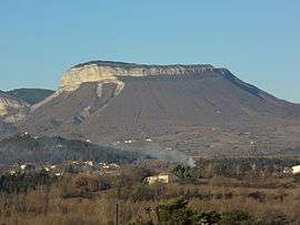 The Montagne de Saint-Genis seen from Ventavon | ||
| ||
 Ventavon Location within Provence-A.-C.d'A. region  Ventavon | ||
| Coordinates: 44°22′18″N 5°54′23″E / 44.3717°N 5.9064°ECoordinates: 44°22′18″N 5°54′23″E / 44.3717°N 5.9064°E | ||
| Country | France | |
| Region | Provence-Alpes-Côte d'Azur | |
| Department | Hautes-Alpes | |
| Arrondissement | Gap | |
| Canton | Laragne-Montéglin | |
| Intercommunality | Laragne | |
| Government | ||
| • Mayor (2008–2014) | Roger Febvre | |
| Area1 | 42.69 km2 (16.48 sq mi) | |
| Population (2008)2 | 517 | |
| • Density | 12/km2 (31/sq mi) | |
| Time zone | UTC+1 (CET) | |
| • Summer (DST) | UTC+2 (CEST) | |
| INSEE/Postal code | 05178 /05300 | |
| Elevation |
503–1,422 m (1,650–4,665 ft) (avg. 685 m or 2,247 ft) | |
|
1 French Land Register data, which excludes lakes, ponds, glaciers > 1 km2 (0.386 sq mi or 247 acres) and river estuaries. 2 Population without double counting: residents of multiple communes (e.g., students and military personnel) only counted once. | ||

Ventavon is a commune in the Hautes-Alpes department in southeastern France.
Population
| Historical population | ||
|---|---|---|
| Year | Pop. | ±% |
| 1962 | 283 | — |
| 1968 | 396 | +39.9% |
| 1975 | 392 | −1.0% |
| 1982 | 362 | −7.7% |
| 1990 | 398 | +9.9% |
| 1999 | 456 | +14.6% |
| 2008 | 517 | +13.4% |
See also
References
| Wikimedia Commons has media related to Ventavon. |
This article is issued from
Wikipedia.
The text is licensed under Creative Commons - Attribution - Sharealike.
Additional terms may apply for the media files.