Sigoyer, Hautes-Alpes
| Sigoyer | ||
|---|---|---|
| Commune | ||
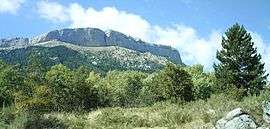 A view of the south side of the Corniche de Céûse, seen from Sigoyer | ||
| ||
 Sigoyer Location within Provence-A.-C.d'A. region  Sigoyer | ||
| Coordinates: 44°28′43″N 5°58′36″E / 44.4786°N 5.9767°ECoordinates: 44°28′43″N 5°58′36″E / 44.4786°N 5.9767°E | ||
| Country | France | |
| Region | Provence-Alpes-Côte d'Azur | |
| Department | Hautes-Alpes | |
| Arrondissement | Gap | |
| Canton | Tallard | |
| Intercommunality | Tallard-Barcillonnette | |
| Government | ||
| • Mayor (2008–2014) | Maurice Ricard | |
| Area1 | 24.38 km2 (9.41 sq mi) | |
| Population (2008)2 | 650 | |
| • Density | 27/km2 (69/sq mi) | |
| Time zone | UTC+1 (CET) | |
| • Summer (DST) | UTC+2 (CEST) | |
| INSEE/Postal code | 05168 /05130 | |
| Elevation |
639–2,000 m (2,096–6,562 ft) (avg. 1,060 m or 3,480 ft) | |
|
1 French Land Register data, which excludes lakes, ponds, glaciers > 1 km2 (0.386 sq mi or 247 acres) and river estuaries. 2 Population without double counting: residents of multiple communes (e.g., students and military personnel) only counted once. | ||

Sigoyer is a commune in the Hautes-Alpes department in southeastern France.
Population
| Historical population | ||
|---|---|---|
| Year | Pop. | ±% |
| 1962 | 304 | — |
| 1968 | 304 | +0.0% |
| 1975 | 245 | −19.4% |
| 1982 | 306 | +24.9% |
| 1990 | 418 | +36.6% |
| 1999 | 583 | +39.5% |
| 2008 | 650 | +11.5% |
See also
References
| Wikimedia Commons has media related to Sigoyer, Hautes-Alpes. |
This article is issued from
Wikipedia.
The text is licensed under Creative Commons - Attribution - Sharealike.
Additional terms may apply for the media files.