Saint-Crépin, Hautes-Alpes
| Saint-Crépin | ||
|---|---|---|
| Commune | ||
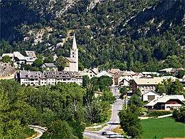 The village of Saint-Crépin, with the church and surrounding buildings | ||
| ||
 Saint-Crépin Location within Provence-A.-C.d'A. region  Saint-Crépin | ||
| Coordinates: 44°42′27″N 6°36′29″E / 44.7075°N 6.6081°ECoordinates: 44°42′27″N 6°36′29″E / 44.7075°N 6.6081°E | ||
| Country | France | |
| Region | Provence-Alpes-Côte d'Azur | |
| Department | Hautes-Alpes | |
| Arrondissement | Briançon | |
| Canton | Guillestre | |
| Intercommunality | Guillestre | |
| Government | ||
| • Mayor (2008–2014) | Bernard Esmieu | |
| Area1 | 46.3 km2 (17.9 sq mi) | |
| Population (2008)2 | 592 | |
| • Density | 13/km2 (33/sq mi) | |
| Time zone | UTC+1 (CET) | |
| • Summer (DST) | UTC+2 (CEST) | |
| INSEE/Postal code | 05136 /05600 | |
| Elevation |
894–2,905 m (2,933–9,531 ft) (avg. 920 m or 3,020 ft) | |
|
1 French Land Register data, which excludes lakes, ponds, glaciers > 1 km2 (0.386 sq mi or 247 acres) and river estuaries. 2 Population without double counting: residents of multiple communes (e.g., students and military personnel) only counted once. | ||
.svg.png)
Saint-Crépin is a commune in the Hautes-Alpes department in southeastern France.
Population
| Historical population | ||
|---|---|---|
| Year | Pop. | ±% |
| 1962 | 391 | — |
| 1968 | 400 | +2.3% |
| 1975 | 402 | +0.5% |
| 1982 | 507 | +26.1% |
| 1990 | 533 | +5.1% |
| 1999 | 541 | +1.5% |
| 2008 | 592 | +9.4% |
See also
References
| Wikimedia Commons has media related to Saint-Crépin, Hautes-Alpes. |
This article is issued from
Wikipedia.
The text is licensed under Creative Commons - Attribution - Sharealike.
Additional terms may apply for the media files.