Phetchaburi Province
| Phetchaburi เพชรบุรี | |||
|---|---|---|---|
| Province | |||
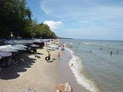 Cha-am Beach | |||
| |||
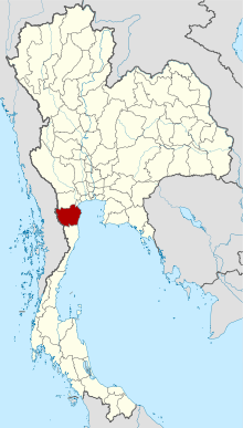 Map of Thailand highlighting Phetchaburi Province | |||
| Country | Thailand | ||
| Capital | Phetchaburi town | ||
| Government | |||
| • Governor | Chatphon Ratdutsadi (since October 2016) | ||
| Area | |||
| • Total | 6,225.1 km2 (2,403.5 sq mi) | ||
| Area rank | Ranked 36th | ||
| Population (2014) | |||
| • Total | 474,192 | ||
| • Rank | Ranked 58th | ||
| • Density | 76/km2 (200/sq mi) | ||
| • Density rank | Ranked 68th | ||
| Time zone | UTC+7 (ICT) | ||
| ISO 3166 code | TH-76 | ||

Phetchaburi (Thai: เพชรบุรี, pronounced [pʰét.t͡ɕʰā.bū.rīː]) or Phet Buri (pronounced [pʰét bū.rīː]) is one of the western or central provinces (changwat) of Thailand.[1] Neighboring provinces are (from north clockwise) Ratchaburi, Samut Songkhram, and Prachuap Khiri Khan. In the west it borders the Tanintharyi Division of Myanmar. Phetchaburi has a national park called "Kaeng Krachan" which consists of a reservoir overlooking its islands.[2]
Geography
Phetchaburi is at the north end of the Malay Peninsula, with the Gulf of Thailand to the east and the Tanaosi mountain range forming the boundary to Myanmar. Except for these border mountains most of the province is a flat plain. With an area of about 3,000 km2 Kaeng Krachan National Park is Thailand's largest national park, covering nearly half of the province.[2] It protects mostly rain forests in the mountains along the boundary to Myanmar, but also the Kaeng Krachan Reservoir is part of the park. The only significant river of the province is the Phetchaburi River.
History
Phetchaburi is an old royal city, dating back to the Mon of the 8th century. Later Khmer settled in the city, as can be seen by the prangs of Wat Kamphaeng Laeng.
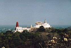
In 1860 King Rama IV built a palace near the city of Phetchaburi, commonly known as Khao Wang, but its official name is Phra Nakhon Khiri. Next to the palace the king built a tower for his astronomical observations. On the adjoining hill is the royal temple Wat Phra Kaeo.
Symbols
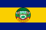
The provincial seal shows the Khao Wang palace in the background. In front are rice fields bordered by two coconut palm trees, symbolizing the major crops in the province.[3]
Provincial tree is Eugenia cumini.
Economy
Phetchaburi Province is an important salt producer. In 2011, 9,880 rai worked by 137 families were devoted to salt production in Phetchaburi.[4]
Administrative divisions
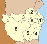
The province is divided into eight districts (amphoe), which are further subdivided into 93 communes (tambons) and 681 villages (mubans).
Transportation
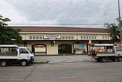
Phetchaburi's main station is Phetchaburi Railway Station.
Tourism
Hat Cha-am (หาดชะอำ) Appearing to have been frozen in time warp, midway between remaining a Thai-style resort, and modernising to meet international tastes and requirements, this extensive pine-fringed beach is considered to be one of the most popular beaches of Thailand.[5]
Maruekhathaiyawan Palace (พระราชนิเวศน์มฤคทายวัน) This beachside wooden palace was formerly used as a royal summer residence by King Rama VI during the 1920s. Facing the open sea, the palace is referred to as the palace of love and hope.[6]
Phra Nakhon Khiri Historical Park (อุทยานประวัติศาสตร์พระนครคีรี) This covers a hilly area with an old palace and historical temples in the vicinity of the town. It consists of royal halls, temples and groups of buildings, constructed mostly in harmonious Thai, Western neoclassic and Chinese architectural styles.[7]
Wat Kamphaeng Laeng (วัดกำแพงแลง) This temple was originally a Khmer place of worship. It was later turned into a Buddhist temple and a shrine hall was constructed. However, the outlook of the place has not much changed due to the existence of sandstone walls and four Khmer style pagodas.[8]
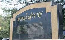
Hat Chao Samran (หาดเจ้าสำราญ) Legend says that King Naresuan the Great and King Eka Thotsarot made several royal visits here and highly appreciated its beauty. The villagers thus rendered it a name "Hat Chao Samran", which means "beach of royal leisure".[9]
References
- ↑ "Phetchaburi". Tourism Authority of Thailand (TAT). Retrieved 2 July 2015.
- 1 2 "Kaeng Krachan National Park". Department of National Parks (DNP) Thailand. Archived from the original on 8 May 2016. Retrieved 2 July 2015.
- ↑ "Phetchaburi". THAILEX Travel Encyclopedia. Retrieved 2 July 2015.
- ↑ Wattanavanitvut, Phongthai (10 September 2016). "Salt industry prepares for a shake-up". Bangkok Post. Retrieved 10 September 2016.
- ↑ "Hat Cha-am". Tourism Authority of Thailand (TAT). Retrieved 2 July 2015.
- ↑ "Maruekhathaiyawan Palace". Tourism Authority of Thailand (TAT). Retrieved 2 July 2015.
- ↑ "Phra Nakhon Khiri Historical Park". Tourism Authority of Thailand (TAT). Retrieved 2 July 2015.
- ↑ "Wat Kamphaeng Laeng". Tourism Authority of Thailand (TAT). Retrieved 2 July 2015.
- ↑ "Hat Chao Samran". TAT. Retrieved 2 July 2015.
External links

- Website of province (Thai only)
| Wikimedia Commons has media related to Phetchaburi. |
Places adjacent to Phetchaburi Province | |
|---|---|