Yasothon Province
| Yasothon ยโสธร | |||
|---|---|---|---|
| Province | |||
| |||
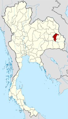 Map of Thailand highlighting Yasothon Province | |||
| Country | Thailand | ||
| Capital | Yasothon | ||
| Government | |||
| • Governor | Buntham Loetsukhikasem (since October 2015) | ||
| Area | |||
| • Total | 4,161.7 km2 (1,606.8 sq mi) | ||
| Area rank | Ranked 54th | ||
| Population (2014) | |||
| • Total | 540,211[1] | ||
| • Rank | Ranked 44th | ||
| • Density rank | Ranked 29th | ||
| Time zone | UTC+7 (ICT) | ||
| ISO 3166 code | TH-35 | ||


Yasothon (Thai: ยโสธร, pronounced [já.sǒː.tʰɔ̄ːn]) is a province (changwat) of Thailand, in the northeast on the Chi River. The province was established by the revolutionary council of Field Marshal Thanom Kittikachorn, after its Announcement No. 70 which came into force on 3 March 1972.
Neighboring provinces are (from north clockwise) Mukdahan, Amnat Charoen, Ubon Ratchathani, Sisaket, and Roi Et.
Geography
The northern part of the province are plains with low hills, while the southern part is the river lowland of the River Chi, with ponds and swamps.
Geology
Yasothon soils (rhodic ferralsols,) formed in the Triassic before the uplift of the Khorat Plateau, are relict soils made fertile by field termites through bioturbation.[2]
History
The province was created on 1 March 1972, when it was split off from Ubon Ratchathani Province.
Symbols
The seal of the province shows two mythical lions, called singh, facing the chedi Pra A-non, in the temple Wat Maha That in the city of Yasothon. In the legendary account of the founding of the city, a lion came out of the forest when the site was chosen; hence the city was called Ban Singh Tha (Thai: บ้านสิงห์ท่า), Home (of) Imposing Lion. (For facts behind the legend, and of two men called Singh, see the city's history).
At the bottom of the seal is a lotus flower (Nymphaea lotus), as the lotus is both the provincial flower of the province and of Ubon Ratchathani Province, of which Yasothon was part until 1972. The provincial tree is Anisoptera costata.
Administrative divisions
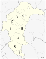
The province is divided into nine districts (amphoe). The districts are further subdivided into 78 communes (tambon) and 835 villages (muban).
Transport

Yasothon is about 500 km (310 mi) from Bangkok at the intersection of Highways of Thailand Routes 23 and 202, and the southern end of Route 2169. Pedicabs serve the city. Tuk-tuks are prohibited. Motorcycle taxis with yellow license plates and drivers with identifying vests serve outlying areas and may take passengers about within the city limits. Several bus lines connect daily and at frequent intervals to Bangkok's Northern Bus Terminal (often called Mo Chit Mai หมอชิดใหม่) and the North Pattaya Terminal, as well as all bus terminals in the north and northeast. Train and air services connect Bangkok to Ubon Ratchathani Province, 100 kilometres east on Route 23. Yasothon's bus terminal re-located from the city centre to the Route 23 Bypass just east of the Ban Kham Noi Junction with Vittaya Thamrong Road/Rural Road YS-2018.
References
- ↑ "Population of the Kingdom" (PDF). Department of Provincial Affairs (DOPA) Thailand (in Thai). 2014-12-31. Retrieved 19 Mar 2015.
- ↑ Lofjle & Kubiniok, Landform development and bioturbation on the Khorat plateau, Northeast Thailand, Nat.Hist.Bull.Siam Soc. (56), 1996 Archived 2011-07-21 at the Wayback Machine.
External links

- Provincial page from the Tourist Authority of Thailand
- Website of province (Thai only)
- Yasothon provincial map, coat of arms and postal stamp
| Wikisource has original text related to this article: |
Places adjacent to Yasothon Province | |
|---|---|
Coordinates: 15°48′8″N 104°8′23″E / 15.80222°N 104.13972°E