Nong Saeng District, Saraburi
| Nong Saeng หนองแซง | |
|---|---|
| District | |
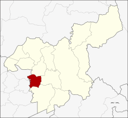 District location in Saraburi Province | |
| Coordinates: 14°29′32″N 100°47′4″E / 14.49222°N 100.78444°ECoordinates: 14°29′32″N 100°47′4″E / 14.49222°N 100.78444°E | |
| Country | Thailand |
| Province | Saraburi |
| Area | |
| • Total | 87.081 km2 (33.622 sq mi) |
| Population (2000) | |
| • Total | 14,781 |
| • Density | 170/km2 (440/sq mi) |
| Time zone | UTC+7 (ICT) |
| Postal code | 18170 |
| Geocode | 1905 |
Nong Saeng (Thai: หนองแซง, pronounced [nɔ̌ːŋ sɛ̄ːŋ]) is a district (amphoe) of Saraburi Province, central Thailand.
History
Originally, the district was a minor district (king amphoe) under Sao Hai District. It was upgraded to a full district in 1953.
The most people of Nong Saeng migrated from Vientiane. They established their new town near a pond surrounded by saeng trees, so they named their new town Ban Nong Saeng.
Geography
Neighboring districts are (from the north clockwise) Sao Hai, Mueang Saraburi, Nong Khae of Saraburi Province, and Phachi and Tha Ruea of Ayutthaya Province.
Administration
The district is divided into nine sub-districts (tambon), which are further subdivided into 69 villages (muban). The township (thesaban tambon) Nong Saeng covers parts of the tambons Nong Saeng, Nong Khwai So, and Kai So. There are a further nine tambon administrative organizations (TAO).
| No. | Name | Thai |
|---|---|---|
| 1. | Nong Saeng | หนองแซง |
| 2. | Nong Khwai So | หนองควายโซ |
| 3. | Nong Hua Pho | หนองหัวโพ |
| 4. | Nong Sida | หนองสีดา |
| 5. | Nong Kop | หนองกบ |
| 6. | Kai Sao | ไก่เส่า |
| 7. | Khok Sa-at | โคกสะอาด |
| 8. | Muang Wan | ม่วงหวาน |
| 9. | Khao Din | เขาดิน |
External links