Samut Prakan Province
| Samut Prakan Province สมุทรปราการ | |||
|---|---|---|---|
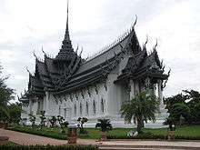
 Wat Phra Samut Chedi | |||
| |||
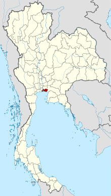 Map of Thailand highlighting Samut Prakan Province | |||
| Country | Thailand | ||
| Capital | Mueang Samut Prakan | ||
| Area | |||
| • Total | 1,004.1 km2 (387.7 sq mi) | ||
| Area rank | Ranked 70th | ||
| Population | |||
| • Total | 1,310,766[1] | ||
| • Rank | Ranked 18th | ||
| • Density rank | Ranked 3rd | ||
| Time zone | UTC+7 (ICT) | ||
| ISO 3166 code | TH-11 | ||
| Website |
www | ||
Samut Prakan (Thai: สมุทรปราการ, pronounced [sāmùt prāːkāːn] (![]()
It is part of the Bangkok Metropolitan Region. Neighbouring provinces are Bangkok, to the north and west, and Chachoengsao to the east.
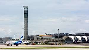
Suvarnabhumi Airport is in the Bang Phli District of Samut Prakan Province.
History
The province was created during the Ayutthaya period, with its administrative centre at Prapadaeng. It was the sea port of Siam, and was secured with forts, town moats, and town walls. King Rama II started the building of the new centre at Samut Prakan in 1819, after his predecessor King Taksin had abandoned the town fortifications. Altogether six forts were built on both sides of the Chao Phraya River, and on an island in the river the pagoda, Phra Samut Chedi, was erected. These were involved in the Paknam incident of 13 July 1893, which ended the Franco-Siamese War with a French naval blockade of Bangkok. Of the original six forts only two still exist today, Phi Sua Samut and Phra Chulachomklao.
Etymology
In Thai the word samut is from Sanskrit, samudra, meaning "ocean" or "sea", and the word prakan is from Sanskrit, prākāra, meaning "fortress", "walls", or "stronghold".
Geography
- Pak Nam and Paknam redirect here
Samut Prakan is at the mouth of the Chao Phraya River on the Gulf of Thailand. Thus the province is also sometimes called Pak Nam (ปากน้ำ), the Thai word for the mouth of a river. The part of the province on the west side of the river consists mostly of rice paddies and shrimp farms as well as mangrove forests, while the eastern part is the urban centre, including industrial factories. It is part of the Bangkok metropolis. The urbanization on both sides of the provincial boundary is identical. The province has a coastline of approximately 47.2 kilometres.

Paknam incident
Samut Prakan is the location of a skirmish between French and Siamese forces on 13 July 1893 subsequently referred to as the Paknam Incident. This battle resulted in a French victory and the signing of the Franco-Siamese Treaty of 3 October 1893 which ceded territory east of the Mekong River to France, territory that forms much of modern Laos.
Symbols
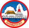
The provincial seal shows the temple Phra Samut Chedi, the most important site of Buddhist worship in the province.
The provincial tree is Thespesia populnea.
The provincial slogan is Marine Battle Fortresses, Chedi in the Water, Crocodile Farm, Exquisite Ancient City, Phra Pradaeng Songkran Festival, Tasty Dried Snakeskin Gourami, Rap Bua Festival, Industrial Estate
Administrative divisions
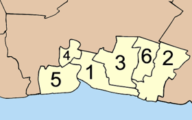
The province is divided into six districts (amphoe). The districts are further subdivided into 50 sub-districts (tambon) and 396 villages (muban). There is one city (thesaban nakhon), three towns (thesaban mueang) and 13 sub-district municipalities (thesaban tambon). For national elections the province is divided into three voting districts, one represented by three assemblymen and the other two each by two assemblymen.
Suvarnabhumi Airport
Suvarnabhumi Airport (RTGS: Suwannaphum; Thai pronunciation: [sù.wān.ná.pʰūːm][2]) (IATA: BKK, ICAO: VTBS), also known as (New) Bangkok International Airport, is one of two international airports serving Bangkok. The other one is Don Mueang International Airport.[3][4] Suvarnabhumi covers an area of 3,240 hectares (8,000 acres).
The airport is on what had formerly been known as Nong Nguhao (Cobra Swamp) in Racha Thewa in Bang Phli, Samut Prakan Province, about 25 kilometres (16 mi) east of downtown Bangkok. The terminal building was designed by Helmut Jahn of Murphy / Jahn Architects. It was constructed primarily by ITO JV. The airport has the world's tallest free-standing control tower (132.2 metres or 434 feet), and the world's fourth largest single-building airport terminal (563,000 square metres or 6,060,000 square feet).
Suvarnabhumi is the twentieth busiest airport in the world, sixth busiest airport in Asia, and the busiest in the country, having handled 53 million passengers in 2012,[5] and is also a major air cargo hub, with a total of 95 airlines. On social networks, Suvarnabhumi was the world's most popular site for taking Instagram photographs in 2012.[6]
The airport inherited the airport code, BKK, from Don Mueang after the older airport ceased international commercial flights. The modern Motorway 7 connects the airport, Bangkok, and the heavily industrial eastern seaboard of Thailand, where most export manufacturing takes place.
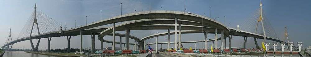
Bhumibol Bridge

The Bhumibol Bridge (Thai: สะพานภูมิพล), also known as the Industrial Ring Road Bridge (Thai: สะพานวงแหวนอุตสาหกรรม) is part of the 13 km long Industrial Ring Road connecting southern Bangkok with Samut Prakan Province. The bridge crosses the Chao Phraya River twice, with two striking cable-stayed spans of lengths of 702 m and 582 m supported by two diamond-shaped pylons 173 m and 164 m high. Where the two spans meet, another road rises to join them at a free-flowing interchange suspended 50 metres above the ground.
The bridge opened for traffic on 20 September 2006, before the official opening date of 5 December 2006. It is part of the Bangkok Industrial Ring Road, a royal scheme initiated by King Bhumibol Adulyadej that aims to solve traffic problems within Bangkok and surrounding areas, especially the industrial area around Khlong Toei Port, Southern Bangkok, and Samut Prakan Province.
According to tradition, all the bridges over the Chao Phraya in Bangkok are named after a member of the royal family. In October 2009, it was announced that both bridges would be named after King Bhumibol Adulyadej,[7] with the northern bridge officially named "Bhumibol 1 Bridge" and the southern bridge "Bhumibol 2 Bridge".[8] The unofficial name "Mega Bridge" was also widely used.[9]
The structure of the Bhumibol Bridge consists of two parts:
- Bhumibol Bridge 1 crosses the northern part of Chao Praya River connecting Yan Nawa District, Bangkok and Song Khanong District, Samut Prakan. It is a cable-stayed bridge with seven lanes together with two high pillars. The structure is reinforced concrete 50 m above the river to enable the passage of ships.
- Bhumibol Bridge 2 is the one across the southern part of Chao Praya River connecting Song Khanong District and Bang Ya Phraek District. The structure is similar to Bhumibol Bridge 1, with seven lanes and two pillars built using reinforced concrete 50 m high.
Economy
Nissan and Honda have automobile factories in the province. Nissan produces hybrid electric vehicles (HEVs) based on its e-Power technology and batteries for electric vehicles at a plant in Bang Sao Thong District. It has a production capacity of 370,000 vehicles a year. Honda produces hybrid electric vehicles and batteries for electric vehicles, at its factories in Prachin Buri and Ayutthaya. Honda's Prachin Buri factory has an annual capacity of 120,000 units.[10]
Gallery
.JPG) Lak Mueang Shrine, Phra Pradaeng
Lak Mueang Shrine, Phra Pradaeng.jpg) Wat Song Tham
Wat Song Tham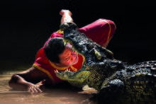 Samut Prakan Crocodile Farm and Zoo
References
- ↑ "Population of the Kingdom". Department of Provincial Affairs (DOPA) Thailand (in Thai). 2017-12-31. Retrieved 4 Apr 2018.
- ↑ "How to pronounce Suvarnabhumi Airport". Forvo. Retrieved 5 March 2017.
- ↑ "Don Mueang to be city budget air hub". Bangkok Post. Retrieved 2 July 2013.
- ↑ "AirAsia to shift to Don Mueang". Archived from the original on 29 October 2013. Retrieved 2 July 2013.
- ↑ 2011 Statistics Archived 27 November 2011 at the Wayback Machine.
- ↑ Bangkok Post, "Suvarnabhumi, Paragon top Instagram places list". Bangkok Post, 29 December 2012.
- ↑ "Bridges Named After His Majesty". The Nation. Archived from the original on 2009-10-24. Retrieved 2012-09-19.
- ↑ "Bhumibol Bridge in Samut Prakan สะพานภูมิพล - Samut Prakan (Paknam) จังหวัดสมุทรปราการ เมืองปากน้ำ". Paknam. 2009-10-21. Archived from the original on 2012-06-25. Retrieved 2012-09-19.
- ↑ "Bangkok's Mega-Bridge" Archived November 26, 2006, at the Wayback Machine. on 2bangkok.com, with many photos of the construction process. The author tentatively claims to have originated the name 'Mega-Bridge'.
- ↑ Theparat, Chatrudee; Maikaew, Piyachart (26 July 2018). "BoI gives blessing to B30bn in plans". Bangkok Post. Retrieved 26 July 2018.
External links

- Province page from the Tourist Authority of Thailand
- paknam.com - created by Sriwittayapaknam School
- Official site of the province (Thai only)
- Samut Prakan provincial map, coat of arms and postal stamp
Places adjacent to Samut Prakan Province | ||||||||||
|---|---|---|---|---|---|---|---|---|---|---|
| ||||||||||
Coordinates: 13°35′58″N 100°35′48″E / 13.59944°N 100.59667°E