Phetchabun Province
| Phetchabun เพชรบูรณ์ | |||
|---|---|---|---|
| Province | |||
| |||
 Map of Thailand highlighting Phetchabun Province | |||
| Coordinates: 16°20′N 101°06′E / 16.333°N 101.100°ECoordinates: 16°20′N 101°06′E / 16.333°N 101.100°E | |||
| Country | Thailand | ||
| Capital | Sadiang | ||
| Government | |||
| • Governor | Phibun Hatthakitkoson (since October 2016) | ||
| Area | |||
| • Total | 12,668.4 km2 (4,891.3 sq mi) | ||
| Area rank | Ranked 9th | ||
| Population (2017) | |||
| • Total | 995,331 | ||
| • Rank | Ranked 19th | ||
| • Density | 79/km2 (200/sq mi) | ||
| • Density rank | Ranked 55th | ||
| Time zone | UTC+7 (ICT) | ||
| ISO 3166 code | TH-67 | ||

Phetchabun (Thai: เพชรบูรณ์, pronounced [pʰét.t͡ɕʰā.būːn]) is one of the central or northern provinces (changwat) of Thailand.[1] Neighboring provinces are (from north clockwise) Loei, Khon Kaen, Chaiyaphum, Lopburi, Nakhon Sawan, Phichit, and Phitsanulok.
Geography
Phetchabun is in the lower northern region of Thailand, in the area between the northern and the central region. The province lies in the broad fertile river valley of the Pa Sak River, with mountains of the Phetchabun mountain range to the east and west. It boasts national parks, waterfalls, and lakes.
Administrative divisions
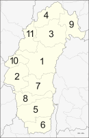
The province is divided into 11 districts (amphoe). These are further subdivided into 117 sub-districts (tambon) and 1261 villages (muban).
Etymology
The word phetcha originates from the Sanskrit word vajra meaning "diamond" (or weapon of Indra), and the word bun from Sanskrit purna meaning "full", "perfect" or "whole". Hence the name of the province literally means "perfect diamond".
Initially, the province was called "Phe-cha-buth" as "Phuenchapura", which means the city that has plenty of crops.[2] The reason is that the province is very fertile and has ample resources. Because of the fertility of the land, Phetchabun has always been agriculturally productive area.
History
Phetchabun was established by two kingdoms: the Sukhothai Kingdom, and the Ayutthaya Period of the King Narai.
In the Thesaphiban administrative reforms at the beginning of the 20th century, the province together with Lom Sak Province to the north formed the monthon Phetchabun. As it was the smallest monthon, it was also the first monthon to be dissolved in 1915, after being temporarily administered from Monthon Phitsanulok between 1903 and 1907. Lom Sak Province was abolished and merged into Phetchabun in 1932.
During the period between 1968-1982 communist insurgents established bases in the mountains in the province. From hidden locations they fought occasional skirmishes against the Thai Army.[3]
Symbols
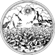
The provincial seal shows a diamond on a mountain, as diamonds are found in the province. In the foreground are tobacco plants, as it is one of the crops grown in the province. The provincial tree is the tamarind.
Transport
Road
Phetchabun is 340 road kilometres north of Bangkok via Route 21.
Air
Phetchabun is served by Phetchabun Airport. Nok Air serves the airport with flights to Bangkok.[4]
Tourism
Sites
- Khao Kho National Park – The north-south long stretch mountain (the west side of Phetchabun Province) is the source of many streams which is on the east side tributary to Yom-Nan Watershed (the main 2 in 25 watersheds in Thailand). Sometimes called "little Switzerland" for its scenery and year-round chill.[3]
- Nam Nao National Park – An immense tract of relatively intact forest.[5]
- Tat Mok National Park (อุทยานแห่งชาติตาดหมอก) has a huge waterfall fed by streams flowing down cracks and crevices of the mountains creating a 12-level fall.[6]
- Si Thep Historical Park (อุทยานประวัติศาสตร์ศรีเทพ) – Some 130 kilometres south of Phetchabun, on Highway 21, is the Si Thep Historical Park. It contains the ruins of ancient Phetchabun, encompassing Si Thep ancient town, originally called Mueang Aphai Sali. It is believed to have been built during the boom years of the ancient Khmer empire, 1,000 years old. The historic town is surrounded by a moat and a mound; inside, ponds and swamps dot the compound.[7]
- The Phetchabun City Pillar Shrine (ศาลหลักเมืองเพชรบูรณ์) was brought over from the ancient town of Si Thep and is considered the oldest such structure in Thailand.[8]
- Wat Trai Phum (วัดไตรภูมิ) on Phetcharat Road features a Buddha statue called Phra Buddha Mahadhamaracha cast in the ornamental Lopburi-style. The ritual bathing of the Buddha image or the traditional Um Phra Dam Nam ceremony is held during September each year.[9]
Festivals
- Um Pra Dam Nam Festival –"Um Pha Dam Nam" or "Dive the Buddha Image into the Water Festival". Phra Buddha Maha Thammaracha is revered ancient Buddha image of Phetchabun Province. This event is annually held on the fifteenth day of the waning moon in the 10th lunar month of during Sat Thai Period at Trai Pum Temple. The image is carried around the town, so Buddhists can pay respect to it and stick gold leaf on its body. The next morning, people make merit as it is SatThai Day. Food and other necessities are given to monks. The Buddha image is then taken to be immersed in the Pah Sak River by the governor of Phetchabun. After the ceremony, the water in the river is regarded as sacred and people swim in it or drink it before the boat racing begins.[10]
- Sweet Tamarind Fair –Sweet tamarind is grown mostly in Phetchabun thanks to the cool weather and suitable environment. The Sweet Tamarind Fair is organized to celebrate the harvest of this fruit during 17–25 January.
Local products
Sweet tamarind (มะขามหวาน) is the "signature" crop of the province.
Notable people
- Saensak Muangsurin (b. 1950), Thai Boxing.
- Khaosai Galaxy (b. 1959), Thai Boxing, a member of the International Boxing Hall of Fame he is widely considered as one of the greatest boxing champions of all time.
- Kaokor Galaxy (b. 1959), Thai Boxing.
- Chana Porpaoin (b. 1966), Thai Boxing.
- Sujin Naknayom (b. 1979), Thai Footballer.
- Chakrit Buathong (b. 1985), Thai Footballer.
- Sittisak Tarapan (b. 1984), Thai Footballer.
References
- ↑ "Phetchabun". Tourism Authority of Thailand (TAT). Retrieved 23 July 2015.
- ↑ Thanarutleasakon, k. (2002). Pra – wat – tai – sart – Thai – ched– sib – hoke – jung -wat [Thai history of 76 provinces]. Bangkok : One World Publishing.
- 1 2 "Khao Kho National Park". Department of National Parks (DNP) Thailand. Archived from the original on 23 July 2015. Retrieved 23 July 2015.
- ↑ https://www.routesonline.com/news/38/airlineroute/279004/nok-air-adds-phetchabun-from-june-2018/
- ↑ "Nam Nao National Park". Department of National Parks (DNP) Thailand. Archived from the original on 23 July 2015. Retrieved 23 July 2015.
- ↑ "Tat Mok National Park". Department of National Parks (DNP) Thailand. Archived from the original on 23 July 2015. Retrieved 23 July 2015.
- ↑ "Si Thep Historical Park". Tourism Authority of Thailand (TAT). Retrieved 23 July 2015.
- ↑ "The city pillar shrine of Phetchaboon". Tourism Authority of Thailand (TAT). Retrieved 23 July 2015.
- ↑ "Wat Trai Phum". Tourism Authority of Thailand (TAT). Retrieved 23 July 2015.
- ↑ "Um Phra Dam Nam". Phetchabun Province. Retrieved 23 July 2015.
External links

- Website of Province (Thai)
- Maps & attractions in Phetchabun
Places adjacent to Phetchabun Province | |
|---|---|