Nan Province
| Nan น่าน | |||
|---|---|---|---|
| Province | |||
| |||
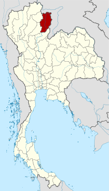 Map of Thailand highlighting Nan Province | |||
| Country | Thailand | ||
| Capital | Nan (town) | ||
| Government | |||
| • Governor | Phaisan Wimonrat (since October 2016) | ||
| Area | |||
| • Total | 11,472.1 km2 (4,429.4 sq mi) | ||
| Area rank | Ranked 13th | ||
| Population (2014) | |||
| • Total | 478,264 | ||
| • Rank | Ranked 55th | ||
| • Density | 42/km2 (110/sq mi) | ||
| • Density rank | Ranked 73rd | ||
| Time zone | UTC+7 (ICT) | ||
| ISO 3166 code | TH-55 | ||
| Website |
www | ||


Nan (Thai: น่าน, pronounced [nâːn]) is one of the northern provinces (changwat) of Thailand. Neighboring provinces are (from south clockwise): Uttaradit, Phrae, and Phayao. To the north and east it borders Sainyabuli of Laos.
Geography

The province is in the remote Nan River valley, surrounded by forested mountains, the Phlueng Range in the western part and the Luang Prabang Range in the east.[1] The highest mountain is the 2,079 meter high Phu Khe in Bo Kluea District, northeast of the city of Nan towards the border with Laos.[2]
Climate
Nan Province has a tropical savanna climate (Köppen climate classification Aw). Winters are quite dry and very warm. Temperatures rise until April, which is very hot with the average daily maximum at 37.0 °C (98.6 °F). The monsoon season runs from late April through October, with heavy rain and somewhat cooler temperatures during the day, although nights remain warm.
History
For centuries Nan was an independent kingdom but, due to its remoteness, had few connections to the other kingdoms. The first kingdom around the city Mueang Pua (also known as Varanagara) was created in the late-13th century. Its rulers, the Phukha dynasty, were related to the founders of Vientiane, however it became associated with the Sukhothai Kingdom as it was easier to reach from the south than from the east or west. In the 14th century the capital was moved to its present location at Nan.
In the 15th century, when Sukhothai declined in power, it became vassal of the kingdom of Lannathai. In 1443 King Kaen Thao of Nan plotted to capture neighboring Phayao by asking King Tilokaraj to help him fight against Vietnamese troops attacking Nan, even though there was no such threat. Kaen Thao killed the king of Phayao, however the troops of Tilokaraj then attacked Nan itself, and captured it in 1449.
When Lannathai was under Burmese rule, Nan tried to liberate itself many times without success, which finally led to Burmese rule of Nan in 1714. In 1788 the Burmese rulers were finally driven out. Nan had to then accept new rulers from Siam. In 1893 after the Paknam crisis Siam had to give a big part of eastern Nan to French Indochina. In 1899 mueang Nan became part of the circle (Monthon) Tawan Tok Chiang Nuea (northwestern circle).[3] In 1916 the northwestern circle was split and Nan was assigned to the circle Maharat.[4] When the circles were abolished in 1932, the provinces including Nan became top-level subdivisions of Siam.
Before the early-1980s, bandits as well as People's Liberation Army of Thailand (PLAT) guerrillas were a big problem in the province, usually destroying highway construction overnight. With the help of the army and the more stable political system the province improved significantly, but is still a very rural and remote area.
Economy
Agriculture is the province's main industry. But, according to Nan Governor Suwat Promsuwan, tourism is up markedly since 2013 and in 2016 contributes an estimated 30 percent to the provincial GDP. Satit Boonthong, president of the Nan Tourism Business Association, says the number of hotel rooms in Nan has doubled to 4,000 in the past two years. Average occupancy is nearly 100 percent during the high season (the cool season) and 50 percent the rest of the year. Room rates have more than doubled since 2009. Mr Satit says that most visitors to Nan are quality tourists who are willing to spend extra on upscale accommodations. The Tourism Department says arrivals to Nan rose by 19 percent to 1.76 million last year, of which Thais constituted 1.44 million. Tourism revenue rose by 14 percent to 4.43 billion baht. The Tourism Authority of Thailand (TAT) expects tourist arrivals to Nan will rise by 10 percent to 1.94 million in 2016 as tourism revenue grows by 10 percent to 4.88 billion baht. Now Nan faces tourist congestion during the high season and on long weekends. In the cool season, the province's six natural parks are booked solid. Provincial authorities are promoting tourism in Pua and Na Noi Districts to relieve congestion in central Nan and distribute tourism income more evenly. "Arrivals to Nan top out at a maximum of 2 million visitors per year," says Mr Suwat. "We want only quality tourists, not a big volume."[5] According to the Bangkok Post, the top two attractions in Nan Province are Doi Samer Dao and Wat Phumin, a temple with many "local art masterpieces".[5]
Environmental issues
Nan and government forestry officials are concerned about deforestation after hill tribes turned 1.5 million rai of forest land into cornfields. Nan Governor, Mr Suwat, says officials have attempted to persuade hill tribes to grow perennial plants such as cashew nuts and bamboo in the forest legally. "It's impossible to solve the deforestation problem without involving the hill tribes," he says. "We must give them a solution to live in the forest and protect nature at the same time."[5]
Demographics
Hill tribes constitute 10.5 percent of the population. Inhabitants known as the T'in or Mal people speak a Northern Mon-Khmer or Khmuic language, T'in, an unknown language when Gérard Diffloth's classifications were widely cited in a 1974 Encyclopædia Britannica article.
Symbols
The provincial seal shows a Usuparatch bull carrying the stupa of Phrathat Chae Haeng. The buffalo dates back to a legend that the rulers of Nan and Phrae were brothers, and met at a mountain to decide about the boundary between their lands. The ruler of Nan went there on a buffalo, while the ruler of Phrae went there on a horse.
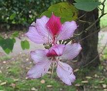
The provincial tree and provincial flower is the Orchid Tree (Bauhinia variegata).
Administrative divisions

The province is divided into 15 districts (amphoe). These are further subdivided into 99 sub-districts (tambons) and 848 villages (mubans).
Gallery
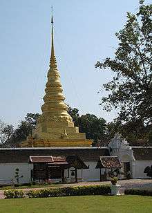
 Wat Phumin, Nan
 Temple frescoes, Wat Nong Bua, Tha Wang Pha
 Rte 1256 snaking towards Doi Phu Kha National Park
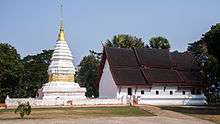 Wat Phrathat Bueng Sakat, Pua District
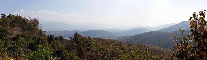 Phi Pan Nam Range, Na Muen District
See also
References
- ↑ ดร.กระมล ทองธรรมชาติ และคณะ, สังคมศึกษา ศาสนาและวัฒนธรรม ม.1, สำนักพิมพ์ อักษรเจริญทัศน์ อจท. จำกัด, 2548, หน้า 24-25
- ↑ "Phu Khe". Wikimapia. Retrieved 18 May 2015.
- ↑ พระบรมราชโองการ ประกาศ เปลี่ยนนามมณฑล (PDF). Royal Gazette (in Thai). 16 (11): 140. 1899-06-11.
- ↑ ประกาศ เลิกมณฑลเพชรบูรณ์เข้าเป็นเมืองในมณฑลพิษณุโลก และแยกมณฑลพายัพเป็นมณฑลมหาราษฎร์ และมณฑลพายัพ รวมเรียกว่า มณฑลภาคพายัพ มีตำแหน่งอุปราชเป็นผู้ตรวจตรากำกับราชการ (PDF). Royal Gazette (in Thai). 32 (0 ก): 200–202. 1915-09-12.
- 1 2 3 Chinmaneevong, Chadamas (2016-02-09). "Northern star". Bangkok Post. Retrieved 9 February 2016.
Further reading
- Filbeck, D. (1978). T'in: a historical study. Pacific linguistics, no. 49. Canberra: Dept. of Linguistics, Research School of Pacific Studies, Australian National University. ISBN 0-85883-172-4
- Goodden, Christian. Hinterlands: Sixteen New Do-It-Yourself Jungle Treks in Thailand's Nan & Mae Hong Son Provinces. Halesworth, England: Jungle Books, 2001. ISBN 0-9527383-3-3
- Scholten, J. J., and Wichai Boonyawat. Detailed Reconnaissance Soil Survey of Nan Province. Kingdom of Thailand, Soil Survey Division, 1972.
External links
| Wikimedia Commons has media related to Nan, Thailand. |

- Tourist Authority of Thailand (TAT): Nan
- Golden Jubilee Network province guide Archived 27 April 2015 at the Wayback Machine.
- Nan provincial map, coat of arms and postal stamp Archived 6 October 2010 at the Wayback Machine.
Places adjacent to Nan Province | ||||||||||
|---|---|---|---|---|---|---|---|---|---|---|
| ||||||||||
Coordinates: 18°46′04.07″N 100°46′56.74″E / 18.7677972°N 100.7824278°E