Phra Nakhon Si Ayutthaya Province
| Phra Nakhon Si Ayutthaya พระนครศรีอยุธยา | |||
|---|---|---|---|
| Province | |||
| |||
| Nickname(s): Ayutthaya | |||
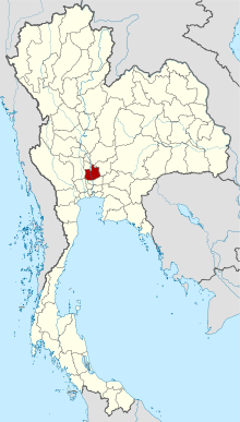 Map of Thailand highlighting Phra Nakhon Si Ayutthaya Province | |||
| Country | Thailand | ||
| Capital | Ayothaya | ||
| Government | |||
| • Governor | Suchin Chaichumsak (since October 2016) | ||
| Area | |||
| • Total | 2,556.6 km2 (987.1 sq mi) | ||
| Area rank | Ranked 62nd | ||
| Population (2014) | |||
| • Total | 803,599 | ||
| • Rank | Ranked 32nd | ||
| • Density | 310/km2 (810/sq mi) | ||
| • Density rank | Ranked 10th | ||
| Time zone | UTC+7 (ICT) | ||
| ISO 3166 code | TH-14 | ||


Phra Nakhon Si Ayutthaya (or Ayutthaya, Thai: พระนครศรีอยุธยา, pronounced [pʰráʔ ná(ʔ).kʰɔ̄ːn sǐː ʔā.jút.tʰā.jāː]) is one of the central provinces (changwat) of Thailand. Neighboring provinces are (from north clockwise) Ang Thong, Lop Buri, Saraburi, Pathum Thani, Nonthaburi, Nakhon Pathom and Suphan Buri.
Etymology
The name Ayutthaya derives from the Sanskrit word Ayodhyā, found in the Ramayana, which means "the invincible [city]". Grammatically, this word is composed of the morphemes a- 'not' + yodhya 'defeatable' (from the root yudh- 'to fight') + ā, a feminine suffix.
Geography
Phra Nakhon Si Ayutthaya, covering 2,556 square kilometres, is on the flat river plain of the Chao Phraya River valley. The presence of the Lopburi and Pa Sak rivers makes the province a major rice farming area. The province is one of only 10 provinces with no forests.[1]
History
Ayutthaya was founded in 1351[a] by King U-Thong. It was the capital of Thailand (then called Siam) for 417 years from 1351 until it was sacked by the Burmese army in 1767. During this era, now usually referred as the Ayutthaya period or Ayutthaya kingdom, Ayutthaya was ruled by 33 kings of five different dynasties. The kingdom became a major regional player, and a trade center of the East, a meeting point of European merchants and Asian traders. Notable monarchs during the Ayutthaya period include King Naresuan the Great, who liberated Ayutthaya from the first Burmese occupation and embarked on a reign of conquest, and King Narai the Great, who initiated diplomatic relations with France, during the reign of Louis XIV. His reign was the golden age of trade and culture.
The city was strategically positioned. During several months of the year, the flood plains around the cities would be flooded by the many rivers around the city. Enemy sieges were thus impossible, and forced to withdraw. This advantage was a contributing factor in the many failed Burmese invasions.
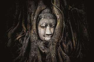
The ruins of the old capital in the Ayutthaya historical park have been a UNESCO World Heritage Site since December 1991. The province is also home to the Bang Pa-in summer palace complex.
Originally named Krung Kao (กรุงเก่า), the province was renamed Phra Nakhon Si Ayutthaya in 1919.[2]
Symbols
According to legend, King Ramathibodi I found a beautiful conch shell buried in the ground, and chose the site as the place for his capital. He then placed the shell on a pedestal tray and built a pavilion around it. The seal shows this pavilion with the provincial tree behind it.
The provincial flower is the ดอกโสน (RTGS: dok sano) Sesbania aculeata, and the provincial tree is the fragrant manjack (Cordia dichotoma). The provincial slogan ราชธานีเก่า อู่ข้าวอู่น้ำ เลิศล้ำกานท์กวี คนดีศรีอยุธยา can be translated as "Old capital city, food larder of the country, poets laureate galore, and national heroes".
Economy
Honda has an automobile factory in the province. Honda produces hybrid electric vehicles (HEVs) and batteries for electric vehicles there, and at its factory in Prachin Buri. Honda's Ayutthaya factory has an annual capacity of 300,000 units.[3]
Administrative divisions
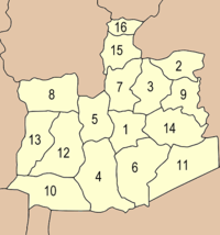
The province is divided into sixteen districts (amphoe), 209 communes (tambon)/sub-districts and 1,328 villages (muban). There are two districts which have the same English name; however this is only because the different pronunciation and thus different spelling in Thai gets lost in romanization. Ayutthaya is unique among the provinces of Thailand in that the district of its seat of government is not called Mueang District [Ayutthaya], as the common scheme would suggest, but rather Phra Nakhon Si Ayutthaya District:
Climate
Ayutthaya, on the central plains, is affected by three seasons:
- Hot Season: March – May
- Rainy season: June – October
- Cool season: November - February
| Climate data for Ayutthaya | |||||||||||||
|---|---|---|---|---|---|---|---|---|---|---|---|---|---|
| Month | Jan | Feb | Mar | Apr | May | Jun | Jul | Aug | Sep | Oct | Nov | Dec | Year |
| Average high °C (°F) | 31.0 (87.8) |
33.3 (91.9) |
35.4 (95.7) |
35.9 (96.6) |
34.3 (93.7) |
32.6 (90.7) |
32.0 (89.6) |
31.4 (88.5) |
31.3 (88.3) |
31.3 (88.3) |
30.7 (87.3) |
30.0 (86) |
32.4 (90.3) |
| Average low °C (°F) | 17.0 (62.6) |
19.4 (66.9) |
22.3 (72.1) |
24.3 (75.7) |
24.5 (76.1) |
24.3 (75.7) |
24.0 (75.2) |
23.8 (74.8) |
23.5 (74.3) |
22.5 (72.5) |
20.0 (68) |
17.4 (63.3) |
21.9 (71.4) |
| Average rainfall mm (inches) | 2.4 (0.094) |
18.8 (0.74) |
43.5 (1.713) |
67.9 (2.673) |
208.0 (8.189) |
223.0 (8.78) |
180.8 (7.118) |
260.0 (10.236) |
213.9 (8.421) |
167.6 (6.598) |
37.1 (1.461) |
0.8 (0.031) |
1,423.8 (56.054) |
| Average rainy days | 0 | 1 | 4 | 6 | 15 | 16 | 17 | 19 | 17 | 12 | 3 | 1 | 111 |
| Source: Thai Meteorological Department[4] | |||||||||||||
Transport
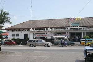
- Rail: Ayutthaya's main station is Ayutthaya Railway Station.
- Boat: Ayutthaya has many piers that can be boarded by river cruise from Bangkok pier.
Tourism
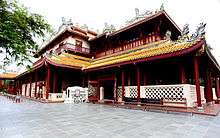
Ayutthaya is 76 kilometres north of Bangkok and boasts numerous ruins. Such ruins indicate that Ayutthaya was one of Indochina's most prosperous cities. The Ayutthaya Historical Park is a vast stretch of historical sites in the heart of Ayutthaya city.
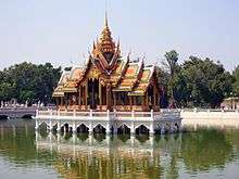
There were three palaces in Ayutthaya: Grand Palace, Chantharakasem Palace or the Front Palace, and Wang Lang or the Rear Palace. In addition, there were many other palaces and buildings for royal visits outside the city area of Phra Nakhon Si Ayutthaya, such as Bang Pa-In Palace at Bang Pa-in and Nakhon Luang Building in the Nakhon Luang District.
Notes
a The city was founded on Friday, the 6th day of the waxing moon of the 5th month, 1893 Buddhist Era, corresponding to Friday, 4 March 1351 Common Era, according to the calculation of the Fine Arts Department of Thailand.[5]
References
- ↑ "Governor bemoans lack of green areas". Bangkok Post. 29 May 2018. Retrieved 29 May 2018.
- ↑ ประกาศกระทรวงมหาดไทย เรื่อง เปลี่ยนนามมณฑลกรุงเก่าและจังหวัดกรุงเก่า (PDF). Royal Gazette (in Thai). 35 (0 ก): 24–27. March 23, 1919.
- ↑ Theparat, Chatrudee; Maikaew, Piyachart (26 July 2018). "BoI gives blessing to B30bn in plans". Bangkok Post. Retrieved 26 July 2018.
- ↑ "30 year Average (1961-1990) - AYUTTHAYA". Thai Meteorological Department. Retrieved 2011-11-12.
- ↑ Rotchanaratha, Wina, ed. (1999). Prachum Phongsawadan Chabap Kanchanaphisek Lem Nueng ประชุมพงศาวดาร ฉบับกาญจนาภิเษก เล่ม ๑ [Golden Jubilee Collection of Historical Archives, Volume 1] (in Thai). Bangkok: Fine Arts Department of Thailand. p. 211. ISBN 9744192151.
See also
External links
| Wikimedia Commons has media related to Ayutthaya. |

- Ayutthaya Expo 2020
- Historical Park of Ayutthaya in Thai Version
- Provincial page, Tourism Authority of Thailand
- Website of province
- Thailand photos of Ayutthaya
- Ayutthaya provincial map, coat of arms and postal stamp
Places adjacent to Phra Nakhon Si Ayutthaya Province | ||||||||||
|---|---|---|---|---|---|---|---|---|---|---|
| ||||||||||
Coordinates: 14°20′58″N 100°33′34″E / 14.34944°N 100.55944°E