Amnat Charoen Province
| Amnat Charoen อำนาจเจริญ | |||
|---|---|---|---|
| Province | |||
| |||
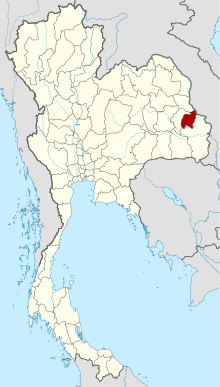 Map of Thailand highlighting Amnat Charoen Province | |||
| Country | Thailand | ||
| Capital | Amnat Charoen | ||
| Government | |||
| • Governor | Sirirat Chum-uppakan (since October 2016) | ||
| Area | |||
| • Total | 3,161.2 km2 (1,220.5 sq mi) | ||
| Area rank | Ranked 60th | ||
| Population (2014) | |||
| • Total | 375,380[1] | ||
| • Rank | Ranked 63rd | ||
| • Density rank | Ranked 40th | ||
| Time zone | UTC+7 (ICT) | ||
| ISO 3166 code | TH-37 | ||
Amnat Charoen (Thai: อำนาจเจริญ, pronounced [ʔām.nâːt t͡ɕā.rɤ̄ːn]) is one of the northeastern provinces (changwat) of Thailand. Neighboring provinces are (clockwise from the south) Ubon Ratchathani, Yasothon, and Mukdahan. To the east it borders Salavan of Laos. Its name is a concatenation of อำนาจ ("authority, power") and เจริญ ("prosperous").[2]
Geography
The province is in the Mekong valley. In dry season, from February to May, water in Mekong River declines, and allows islands to appear. Islands include Kaeng Tanglang at Si Sombun Village, close to Amphoe Chanuman, and Kaeng Hin Khan at Ban Hin Khan, 30 kilometres south of Amphoe Chanuman. The other two rivers in the province are the Lam Sae Bok and Lam Sae Bai.
Phu Sa Dok Bua National Park occupies part of Amnat Charoen Province.
History
Amnat Charoen gained city status during the reign of King Rama III. It was first administered from Nakhon Khemarat, and later from Ubon Ratchathani. It became a province in its own right on 12 January 1993, when it was split off from Ubon Ratchathani. It is thus one of the three newest provinces of Thailand, together with Nong Bua Lam Phu and Sa Kaeo.
Economy
The province is overwhelmingly agricultural. In 2008, Amnat Charoen locals developed the so-called "Dhamma agriculture" model based on self-governance and aimed at making the province a hub for organic farming. According to the Office of Agriculture Economics, Amnat Charoen in 2016 had a total of 883,499 rai planted in hom mali rice. Sugarcane plantations increased from 40,688 rai in 2015 to 51,446 rai in 2016.[3]
Symbols
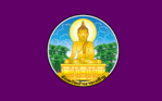
In the middle of the provincial seal is an image of the Buddha called Phra Mongkol Ming Muang. Also known as Phra Yai (Big Buddha), this 20 m high statue is among the most sacred in the city of Amnat Charoen.[2]
The provincial tree is Hopea ferrea.
The provincial slogan is Phra Mongkhon, seven river basins, sacred caves, Phra Lao, beautiful islands and mountain, precious silk and religious people.
Administrative divisions
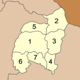
The province is divided into seven districts (amphoe). The districts are further subdivided into 56 communes (tambon) and 653 villages (muban).
See also
References
- ↑ "Population of the Kingdom" (PDF). Department of Provincial Affairs (DOPA) Thailand (in Thai). 2014-12-31. Retrieved 19 Mar 2015.
- 1 2 "Amnat Charoen". Thailex Travel Encyclopedia. Retrieved 29 January 2016.
- ↑ Kotamee, Itthiphon; Pratthanawutthikun, Pitak (17 November 2017). "Sugarcane is stealing the thunder of the organic rice movement in Amnat Charoen". Isaan Record. Retrieved 19 November 2017.
External links

- Province page from the Tourist Authority of Thailand
- Website of the province (Thai only)
Places adjacent to Amnat Charoen Province | ||||||||||
|---|---|---|---|---|---|---|---|---|---|---|
| ||||||||||
Coordinates: 15°54′5″N 104°37′22″E / 15.90139°N 104.62278°E