Mueang Saraburi District
| Mueang Saraburi เมืองสระบุรี | |
|---|---|
| Amphoe | |
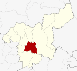 Amphoe location in Saraburi Province | |
| Coordinates: 14°31′38″N 100°54′35″E / 14.52722°N 100.90972°ECoordinates: 14°31′38″N 100°54′35″E / 14.52722°N 100.90972°E | |
| Country | Thailand |
| Province | Saraburi |
| Area | |
| • Total | 301.6 km2 (116.4 sq mi) |
| Population (2000) | |
| • Total | 106,107 |
| • Density | 350/km2 (910/sq mi) |
| Time zone | UTC+7 (ICT) |
| Postal code | 18000 |
| Geocode | 1901 |
Mueang Saraburi (Thai: เมืองสระบุรี) is the capital district (amphoe mueang) of Saraburi Province, central Thailand.
History
In 1896 when the Northeastern railway was built and passed by Tambon Pak Phriao. The governor of Saraburi, Phraya Phichai Ronnarong Songkhram moved the capital district from Sao Hai District to the area.
Geography
Neighboring districts are (from the north clockwise) Chaloem Phra Kiat, Kaeng Khoi, Wihan Daeng, Nong Khae, Nong Saeng and Sao Hai.
Mueang Saraburi is an important land transportation hub. Mittraphap Road begins downtown. The northeastern railway line passes through it.
Administration
The district is divided into 11 sub-districts (tambon), which are further subdivided into 77 villages (muban). The town (thesaban mueang) Saraburi covers the whole tambon Pak Phriao. The township (thesaban tambon) Phok Phaek covers part of the tambon Nong No. Kut Nok Plao and Takut are two further recently created townships.
| No. | Name | Thai |
|---|---|---|
| 1. | Pak Phriao | ปากเพรียว |
| 5. | Dao Rueang | ดาวเรือง |
| 6. | Na Chong | นาโฉง |
| 7. | Khok Sawang | โคกสว่าง |
| 8. | Nong No | หนองโน |
| 9. | Nong Yao | หนองยาว |
| 10. | Pak Khao San | ปากข้าวสาร |
| 11. | Nong Pla Lai | หนองปลาไหล |
| 12. | Kut Nok Plao | กุดนกเปล้า |
| 13. | Taling Chan | ตลิ่งชัน |
| 14. | Takut | ตะกุด |
Missing numbers are tambon which now from the district Chaloem Phra Kiat.