Latehar district
| Latehar district | |
|---|---|
| District of Jharkhand | |
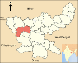 Location of Latehar district in Jharkhand | |
| Country | India |
| State | Jharkhand |
| Administrative division | palamu |
| Headquarters | Latehar |
| Government | |
| • Lok Sabha constituencies | Chatra (shared with Chatra district) |
| • Assembly seats | 2 |
| Area | |
| • Total | 3,659.59 km2 (1,412.98 sq mi) |
| Population (2011) | |
| • Total | 725,673 |
| • Density | 200/km2 (510/sq mi) |
| Demographics | |
| • Literacy | 61.23 per cent |
| • Sex ratio | 964 |
| Website | Official website |
Latehar district is one of the twenty-four districts of Jharkhand state in eastern India, and Latehar town is the administrative headquarters of this district. This district is part of Palamu division.
Latehar district is situated between 84deg. 31 min. East latitude 23 deg. 44.4 min north latitude. The area of the district is 3660 km², with a population of 558,831 (2001 census).
History
The territory covered by the present district became a part of Palamu district, when it formed on 1 January 1928. Latehar district was created on 4 April 2001 by separating the erstwhile Latehar subdivision of Palamu district. It is currently a part of the Red Corridor.[1]
Administration
Blocks/Mandals
Latehar district consists of 9 blocks. The following are the list of the blocks in Latehar district:
Geography
Latehar district has two of the highest waterfalls in Jharkhand – Lodh Falls and Lower Ghaghri Falls, along with several others.[2]
Betla National Park is located in this District.
Economy
In 2006 the Indian government named Latehar one of the country's 250 most backward districts (out of a total of 640).[3] It is one of the 24 districts in Jharkhand currently receiving funds from the Backward Regions Grant Fund Programme (BRGF).[3]
Divisions
There are 9 Development Blocks, namely Latehar, Chandwa, Balumath, Bariyatu, Herhanj, Manika, Barwadih, Garu and Mahuadanr
There are two Vidhan Sabha constituencies in this district: Manika and Latehar. Both are part of Chatra Lok Sabha constituency.
Demographics
According to the 2011 census Latehar district has a population of 725,673,[4] roughly equal to the nation of Bhutan[5] or the US state of Alaska.[6] This gives it a ranking of 499th in India (out of a total of 640).[4] The district has a population density of 200 inhabitants per square kilometre (520/sq mi) .[4] Its population growth rate over the decade 2001-2011 was 29.38%.[4] Latehar has a sex ratio of 964 females for every 1000 males,[4] and a literacy rate of 61.23%.[4]
See also
References
- ↑ "83 districts under the Security Related Expenditure Scheme". IntelliBriefs. 2009-12-11. Retrieved 2011-09-17.
- ↑ "Showing all Waterfalls in India". World Waterfalls Database. Archived from the original on 2012-08-25. Retrieved 2010-06-20.
- 1 2 Ministry of Panchayati Raj (September 8, 2009). "A Note on the Backward Regions Grant Fund Programme" (PDF). National Institute of Rural Development. Archived from the original (PDF) on April 5, 2012. Retrieved September 27, 2011.
- 1 2 3 4 5 6 "District Census 2011". Census2011.co.in. 2011. Retrieved 2011-09-30.
- ↑ US Directorate of Intelligence. "Country Comparison:Population". Retrieved 2011-10-01.
Bhutan 708,427
- ↑ "2010 Resident Population Data". U. S. Census Bureau. Archived from the original on 2013-10-19. Retrieved 2011-09-30.
Alaska 710,231
External links
| Wikimedia Commons has media related to Latehar district. |
Places adjacent to Latehar district | |
|---|---|
Coordinates: 23°43′48″N 84°28′12″E / 23.73000°N 84.47000°E