Redwood City, California
| Redwood City, California | ||
|---|---|---|
| City in California | ||
| City of Redwood City | ||
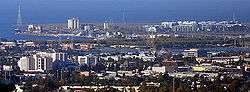 The skyline of downtown Redwood City | ||
| ||
| Motto(s): "Climate Best by Government Test"[1] | ||
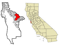 Location in San Mateo County and the state of California | ||
 Redwood City, California Location in the United States | ||
| Coordinates: 37°28′58″N 122°14′10″W / 37.48278°N 122.23611°WCoordinates: 37°28′58″N 122°14′10″W / 37.48278°N 122.23611°W | ||
| Country |
| |
| State |
| |
| County | San Mateo | |
| Incorporated | May 11, 1867[2][3] | |
| Re-incorporated | May 3, 1897[3] | |
| Government | ||
| • Mayor | Ian Bain[4] | |
| Area[5] | ||
| • Total | 34.67 sq mi (89.80 km2) | |
| • Land | 19.30 sq mi (49.98 km2) | |
| • Water | 15.38 sq mi (39.82 km2) 43.91% | |
| Elevation[3] | 20 ft (6 m) | |
| Population (2010) | ||
| • Total | 76,815 | |
| • Estimate (2016)[6] | 84,950 | |
| • Density | 4,402.47/sq mi (1,699.79/km2) | |
| Time zone | UTC-8 (Pacific) | |
| • Summer (DST) | UTC-7 (PDT) | |
| ZIP codes | 94059, 94061–94065 | |
| Area code | 650 | |
| FIPS code | 06-60102 | |
| GNIS feature IDs | 277584, 2410919 | |
| Primary Airports |
San Jose International Airport (SJC) San Francisco International Airport (SFO) | |
| U.S. Routes |
| |
| State Routes |
| |
| Commuter Rail |
| |
| Website |
redwoodcity | |
Redwood City is a city on the San Francisco Peninsula in Northern California's Bay Area, approximately 27 miles (43 km) south of San Francisco, and 24 miles (39 km) northwest of San Jose. Redwood City's history spans its earliest inhabitation by the Ohlone people to being a port for lumber and other goods. The county seat of San Mateo County, it is the home of several technology companies such as Box, Informatica, Oracle, Evernote, Wealthfront,[7] and Electronic Arts. At the 2010 census, the city had a population of 76,815. The Port of Redwood City is the only deepwater port on San Francisco Bay south of San Francisco. Redwood City is the location of the San Mateo County Jail, for both women and men. The Malibu Grand Prix long time landmark was recently demolished along with the city's only Mini Golf, Go-Kart, Video Game Arcade, and Batting Cages. Malibu Grand Prix's previous location is currently the construction site of a new additional Jail and Inmate housing facility. The city has a motto "Climate Best By Government Test" which is a reference to it being one of the top German scouted scientific climates and the city was one of the locations mapped by them during their testing and data collection. The Hetch Hetchy water pipeline runs through Redwood City and supplies a vast majority of the surrounding area with low grain (+/− 3 grains) rated water.
According to the United States Census Bureau, the city has an area of 34.7 square miles (90 km2), of which 19.4 square miles (50 km2) is land and 15.2 square miles (39 km2) (43.91%) is water. A major watercourse draining much of Redwood City is Redwood Creek, to which several significant river deltas connect, the largest of which is Westpoint Slough.
Geography
Redwood City stretches from the San Francisco Bay towards the Santa Cruz Mountains between San Carlos to the northwest and Atherton to the southeast with Woodside to the southwest. It is divided by Highway 101 and further inland El Camino Real on the northwest/southeast axis and Woodside Road on the north-northeast/south-southwest axis. Locally, the former two are regarded as north/south and the latter east/west, as 101 and El Camino connects Redwood City to San Francisco and San Jose and Woodside Road runs from San Francisco Bay to the Santa Cruz Mountains.
Neighborhoods include Bair Island to the northeast of Highway 101. The northern neighborhood of Redwood Shores also to the northeast of Highway 101 is part of Redwood City, although it is not possible to travel by road from one to the other without passing through the neighboring city of San Carlos, or through Belmont via unincorporated San Mateo County. Stretching along Highway 101 to the southeast of Woodside Road is Friendly Acres, further inland and still to the southeast of Woodside Road are Redwood Village and then Redwood Oaks. Most neighborhoods are to the northwest of Woodside Ride and southwest of Highway 101. Centennial, Downtown, and Stambaugh Heller are adjacent to 101. Next inland are Edgewood, Mt. Carmel, Central and Palm then Canyon, Eagle Hill, Roosevelt, and Woodside Plaza. Furthest inland is Farm Hills (or Farm Hill).[8]
Neighborhoods associated with Redwood City but not part of the incorporated city include Emerald Lake Hills and Kensington Square inland and to the north and North Fair Oaks to the southeast. Palomar Park, just north of Emerald Hills and east of San Carlos' Crestview area, is another Redwood City neighborhood that is formally part of unincorporated San Mateo County. Although Redwood City has a large middle class, the south eastern section of Redwood City highly resembles working class North Fair Oaks in demographic make-up and income level.
Climate
Redwood City, along with most of the Bay Area, enjoys a mild Mediterranean climate (Köppen climate classification Csb), with warm, dry summers and cool, relatively wet winters. The National Weather Service, which maintains both a forecast center and a cooperative office in Redwood City, reports that December is the coolest month and July is the warmest month. The record highest temperature of 110 °F (43.3 °C) and was recorded on July 14 and 15, 1972. The record lowest temperature of 16 °F (−8.8 °C) was recorded on January 11, 1949. Annually, there are an average of 21.6 days with highs of 90 °F (32 °C) or higher and 2.8 days with highs of 100 °F (38 °C) or higher; there are an average of 10.4 days with lows of 32 °F (0 °C) or lower.
The normal annual precipitation is 20.56 inches (52.22 cm). The most rainfall in one month was 12.42 inches (31.55 cm) in February 1998. The record 24-hour rainfall of 4.88 inches (12.4 cm) was on October 13, 1962. There are an average of 62.1 days with measurable precipitation. Snow flurries have been observed on rare occasions; there was some minor snow accumulation in May 1935, January 1962, and February 1976.
| Climate data for Redwood City, California | |||||||||||||
|---|---|---|---|---|---|---|---|---|---|---|---|---|---|
| Month | Jan | Feb | Mar | Apr | May | Jun | Jul | Aug | Sep | Oct | Nov | Dec | Year |
| Record high °F (°C) | 78 (26) |
80 (27) |
89 (32) |
97 (36) |
102 (39) |
109 (43) |
110 (43) |
105 (41) |
108 (42) |
104 (40) |
87 (31) |
77 (25) |
110 (43) |
| Average high °F (°C) | 58.5 (14.7) |
62.3 (16.8) |
65.5 (18.6) |
70.2 (21.2) |
74.4 (23.6) |
79.2 (26.2) |
82.4 (28) |
82.1 (27.8) |
80.2 (26.8) |
74.4 (23.6) |
65.3 (18.5) |
58.2 (14.6) |
71.1 (21.7) |
| Average low °F (°C) | 40.3 (4.6) |
43.8 (6.6) |
45.2 (7.3) |
46.5 (8.1) |
50.7 (10.4) |
54.3 (12.4) |
56.3 (13.5) |
56.5 (13.6) |
54.4 (12.4) |
50.5 (10.3) |
44.3 (6.8) |
40.1 (4.5) |
48.6 (9.2) |
| Record low °F (°C) | 16 (−9) |
25 (−4) |
29 (−2) |
33 (1) |
36 (2) |
39 (4) |
40 (4) |
43 (6) |
38 (3) |
33 (1) |
29 (−2) |
19 (−7) |
16 (−9) |
| Average precipitation inches (mm) | 4.02 (102.1) |
4.09 (103.9) |
3.13 (79.5) |
1.16 (29.5) |
0.47 (11.9) |
0.1 (3) |
0.01 (0.3) |
0.05 (1.3) |
0.16 (4.1) |
1.06 (26.9) |
2.37 (60.2) |
3.84 (97.5) |
20.46 (520.2) |
| Source: "The Weather Channel[9] | |||||||||||||
History
Redwood City incorporated in 1867, the first city to do so in San Mateo County, and it has been the county seat since the county was formed in 1856.[10] The land had been part of the Rancho de las Pulgas granted to the Arguello family in 1835 by the Mexican government. Their control was challenged after the Mexican–American War when California became part of the United States. The family lawyer, Simon M. Mezes, in 1854 defended the claim somewhat successfully and was allowed to buy the part of the estate that is now Redwood City. Mezes sold some of the land to people already squatting on it along the banks of Redwood Creek and named the settlement, Mezesville. Though the city did not keep that name, Mezes Park still exists on land Mezes had given for open space.[11]
In 1907 Eikichi and Sadakusi Enomoto, Japanese immigrant brothers, grew perhaps the first chrysanthemums commercially in the United States in Redwood City. In 1926 the chamber of commerce proclaimed the city the "Chrysanthemum Center of the World" though the internment of Japanese Americans in 1941 and other factors removed flower growing as a major industry in the city.[12][13]
Demographics
| Historical population | |||
|---|---|---|---|
| Census | Pop. | %± | |
| 1870 | 727 | — | |
| 1880 | 1,383 | 90.2% | |
| 1890 | 1,572 | 13.7% | |
| 1900 | 1,653 | 5.2% | |
| 1910 | 2,442 | 47.7% | |
| 1920 | 4,020 | 64.6% | |
| 1930 | 8,962 | 122.9% | |
| 1940 | 12,453 | 39.0% | |
| 1950 | 25,544 | 105.1% | |
| 1960 | 46,290 | 81.2% | |
| 1970 | 55,686 | 20.3% | |
| 1980 | 54,951 | −1.3% | |
| 1990 | 66,072 | 20.2% | |
| 2000 | 75,402 | 14.1% | |
| 2010 | 76,815 | 1.9% | |
| Est. 2016 | 84,950 | [6] | 10.6% |
| U.S. Decennial Census[14] | |||
2010
The 2010 United States Census[15] reported that Redwood City had a population of 76,815. The population density was 3,955.5 people per square mile (1,527.2/km²). The racial makeup of Redwood City was 46,255 (60.2%) White, 1,881 (2.4%) African American, 511 (0.7%) Native American, 8,216 (10.7%) Asian, 795 (1.0%) Pacific Islander, 14,967 (19.5%) from other races, and 4,190 (5.5%) from two or more races. Hispanic or Latino of any race were 29,810 persons (38.8%). Non-Hispanic Whites number 31,982 (40.9%).
The Census reported that 75,268 people (98.0% of the population) lived in households, 408 (0.5%) lived in non-institutionalized group quarters, and 1,139 (1.5%) were institutionalized.
There were 27,957 households, out of which 10,045 (35.9%) had children under the age of 18 living in them, 13,642 (48.8%) were opposite-sex married couples living together, 3,139 (11.2%) had a female householder with no husband present, 1,461 (5.2%) had a male householder with no wife present. There were 1,818 (6.5%) unmarried opposite-sex partnerships, and 288 (1.0%) same-sex married couples or partnerships. 7,411 households (26.5%) were made up of individuals and 2,401 (8.6%) had someone living alone who was 65 years of age or older. The average household size was 2.69. There were 18,242 families (65.3% of all households); the average family size was 3.26.
The population was spread out with 18,193 people (23.7%) under the age of 18, 5,981 people (7.8%) aged 18 to 24, 24,819 people (32.3%) aged 25 to 44, 19,710 people (25.7%) aged 45 to 64, and 8,112 people (10.6%) who were 65 years of age or older. The median age was 36.7 years. For every 100 females, there were 99.2 males. For every 100 females age 18 and over, there were 98.1 males.
There were 29,167 housing units at an average density of 1,501.9 per square mile (579.9/km²), of which 14,160 (50.6%) were owner-occupied, and 13,797 (49.4%) were occupied by renters. The homeowner vacancy rate was 1.3%; the rental vacancy rate was 3.9%. 37,757 people (49.2% of the population) lived in owner-occupied housing units and 37,511 people (48.8%) lived in rental housing units.
|
2000
In 2000, there were 75,402 people, 27,423 households and 17,898 families residing in the city. The population density was 3,882.7 people per square mile (1,499.1/km²). There were 29,568 housing units at an average density of 1,522.6 per square mile (550.3/km²). 47.1% spoke English, 39.6% Spanish, 2.4% Chinese or Mandarin, other Indo-European 1.7%, and other language 0.5%, as their first language from estimate census 2009.
There were 27,680 households out of which 31.5% had children under the age of 18 living with them, 44.4% were married couples living together, 14.7% had a female householder with no husband present, and 40.2% were non-families. 31.5% of all households were made up of individuals and 6.3% had someone living alone who was 65 years of age or older. The average household size was 4.62 and the average family size was 4.80.
In the city, the population was spread out with 30.6% under the age of 18, 14.7% from 18 to 24, 33.3% from 25 to 44, 17.4% from 45 to 64, and 7.4% who were 65 years of age or older. The median age was 28 years. For every 100 females, there were 103.2 males. For every 100 females age 18 and over, there were 101.4 males.
According to a 2009 estimate, the median income for a household in the city was $69,679, and the median income for a family was $77,964. Disposable income is relatively constant when Redwood City is compared with the rest of the country.[17] Males had a median income of $47,345 versus $44,125 for females. The per capita income for the city was $31,042. About 8.4% of families and 10.2% of the population were below the poverty line, including 11.1% of those under age 18 and 9.4% of those age 65 or over.
Government
Redwood City's charter provides for a councilor-manager form of government. The City Council appoints the City Manager and adopts policies, which the City Manager is expected to implement. The City Manager appoints and manages most of Redwood City's department heads (the City Clerk and City Attorney being notable exceptions).
The City Council seats are currently held by Ian Bain (serving as the Mayor), Diane Howard (serving as Vice Mayor), Alicia C. Aguirre, Jeffrey Gee, Janet Borgens, Shelly Masur and John D. Seybert. The current City Manager is Melissa Stevenson Diaz.[18]
In the California State Legislature, Redwood City is in the 13th Senate District, represented by Democrat Jerry Hill, and in the 22nd Assembly District, represented by Democrat Kevin Mullin.[19][20]
In the United States House of Representatives, Redwood City is split between California's 14th and 18th congressional districts,[21] represented by Jackie Speier (D–Hillsborough) and Anna Eshoo (D–Atherton), respectively.[22]
Downtown
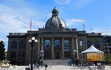
In an attempt to revitalize Redwood City's downtown, city officials decided to look into development. In February 1999 the San Mateo County History Museum opened inside the old San Mateo County Courthouse in downtown Redwood City.[23] The courthouse had been built in 1910 and in the late '30s an addition was built in front of the original structure, obscuring the view. The addition was torn down and been replaced with a large courtyard flanked by water fountains on either side, leading to the main steps of the courthouse as part of the revitalization. The courthouse's glass dome is lit at night and changes colors every 11 seconds.
In August 2006, a 20-screen theater and various shops opened in a prime downtown location. The theater complex boasts restaurant and retail space at street level and a 2-level underground parking structure.[24]
Landmarks
- Union Cemetery, State Historical Landmark #816[25]
- Fox Theatre[26]
- Lathrop House[27]
- Sequoia High School[28]
Parks
Preserves include Bair Island Ecological Preserve (State) and the Don Edwards National Wildlife Refuge on the shoreline.[29] Edgewood County Park known for its wildflowers towards the Santa Cruz Mountains.
City parks include
- Andrew Spinas Park (1.46 acres or 0.59 hectares) – 2nd Ave./Bay Rd. Established in 1966 and named for Andrew L. Spinas a long time Redwood City teacher and school superintendent who served on the Parks and Recreation Commission from 1938 to 1953.[30]
- Dolphin Park (2.36 acres or 0.96 hectares) – Turks Head/Quay Ln.
- Dove Beeger Park (1 acre or 0.40 hectares) – Whipple Ave./Circle Rd.
- Fleishman Park (.63 acres or 0.25 hectares) – Locust St./McEvoy St.
- Garrett Park (6.9 acres or 2.8 hectares) – 3600 Block Glenwood Ave.
- Hawes Park (1.59 acres or 0.64 hectares) – Hudson St./Roosevelt Ave. Built in 1934 and named for Horace Hawes, state assemblyman, who in 1864 donated land and money to the city for a new school.[30]
- Hoover Park (10.18 acres or 4.12 hectares) – Woodside Rd./Spring St.
- Jardin de Niños (.31 acres or 0.13 hectares) – Middlefield Rd./Chestnut St.
- Linden Park (.22 acres or 0.089 hectares) – Linden St./Park St.
- Maddux Park (.62 acres or 0.25 hectares) – Maddux Dr./Kensington Rd.
- Mariner Park (6.25 acres or 2.53 hectares) – Tiller Lane/Bridge Parkway
- Marlin Park (11.15 acres or 4.51 hectares) – Neptune Dr./Cringle Dr.
- Mezes Park (1.67 acres or 0.68 hectares) – Warren St./Standish St.
- Palm Park (.9 acres or 0.36 hectares) – Hudson St./Palm Ave.
- Preserve Park (3.5 acres or 1.4 hectares) – 99 Shearwater Parkway
- Red Morton Community Park (31.74 acres or 12.84 hectares) – 1120 Roosevelt Ave.
- Sandpiper Park (11.07 acres or 4.48 hectares) – Redwood Shores Parkway and Egret Ln.
- Shannon Park (1.87 acres or 0.76 hectares) – Davit Lane/Shannon Way
- Shore Dogs Park (.69 acres or 0.28 hectares) – 1300 Block Radio Rd.
- Shorebird Park (3.68 acres or 1.49 hectares) – Marine Parkway/Island Dr.
- Stafford Park (1.62 acres or 0.66 hectares) – King St./Hopkins Ave. Established in 1946 and named for the donor, Daniel R. Stafford (1870-1948) who had been a Redwood City grocer, city clerk, and mayor.[30]
- Stulsaft Park (42.06 acres or 17.02 hectares) – 3737 Farm Hill Blvd. Established in 1951 and named for the real estate developer, Morris Stulsaft, who donated the land.[30]
- Wellesley Crescent Park (.75 acres or 0.30 hectares) – Edgewood Rd./Arlington Rd.
- Westwood Park (.25 acres or 0.10 hectares) – Westwood St./Briarfield Ave.
Education
Redwood City has one state community college, Cañada College.
It has elementary and middle schools operated by the Redwood City School District. At the high school level it is part of the Sequoia Union High School District and high schools in Redwood City that are part of this district are the comprehensive Sequoia High School, the charter schools Summit Preparatory Charter High School and Everest Public High School, and the continuation school Redwood High School. Many students from Redwood City attend another Sequoia Union school, Woodside High School, in the neighboring town of Woodside.[31]
The Redwood City Libraries system, a member of the Peninsula Library System, has four branches in the city: Downtown, Fair Oaks, Redwood Shores, and Schaberg.[32] The city's first library opened in 1865 and in 1900 the city passed a special tax to support a free public library. In 1904 Andrew Carnegie gave $10,000 for a new library; he gave another $6,000 in 1906 to rebuild it after it was destroyed in the earthquake. In 1959 Schaberg library opened and was named for Hannah Schaberg who left money for its building in her will.[12]
Slogan
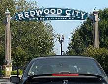
Redwood City's slogan, emblazoned on arches across Broadway at the east and west entrances to downtown, is "Climate Best By Government Test." This is based on a climatological survey conducted by the United States and German governments prior to World War I. The area centered on Redwood City tied for the world's best climate with the Canary Islands and North Africa's Mediterranean Coast.[33]
Independence Day parade
Redwood City's Independence Day parade sponsored by the Peninsula Celebration Association,[34] held continuously since 1939, has been billed variously as 'The largest Independence Day Parade in California,' 'West of the Mississippi,' 'in North America,' claims which may or may not be accurate. The first verifiable written records of celebrations date to 1861, and to 1887 for a parade.
Notable people
Sports
.jpg)
- Davante Adams, professional football wide receiver for the Green Bay Packers, was born in Redwood City
- Kevin Bass, former right fielder for the Houston Astros and the San Francisco Giants.
- Geoff Blum, broadcaster for Houston Astros, infielder from 1999-2012 with Montreal Expos, Tampa Bay Devil Rays, San Diego Padres, Arizona Diamondbacks, Chicago White Sox and Astros, homered in 14th inning to win Game 3 of 2005 World Series; was born in Redwood City
- Eric Byrnes, former Major League Baseball outfielder, was born in Redwood City[35]
- Joe Biagini, baseball player for the Toronto Blue Jays
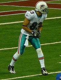
- Greg Camarillo (born 1982), former Minnesota Vikings wide receiver, was born in Redwood City[36]
- Chris Carter, current Milwaukee Brewers first baseman, was born in Redwood City
- Jeff Clark, one of the most famous big wave surfers who surfed Mavericks alone for 15 years and was credited with starting the Mavericks surf competition, was born in Redwood City
- Daniel Descalso, infielder for the St. Louis Cardinals, was born in Redwood City[37]
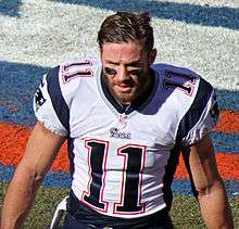
- Julian Edelman (born 1986), wide receiver for the New England Patriots, was born in Redwood City
- Don Mossi, Major League Baseball pitcher, lived at 1925 Vera Avenue in Redwood City; during the 1960s, the home was lent to players from the San Francisco Giants while Mossi was on the road.
- Daniel Nava, outfielder for the Los Angeles Angels of Anaheim, was born in Redwood City[38]
- Brian Shima, professional inline skater born and raised in Redwood City
- Zach Test (born 1989), rugby union player
- Matangi Tonga, American football player
- Roy Williams, 5x time Pro Bowler in the National Football League was born in Redwood City, California
- Lily Zhang, Olympic table tennis player
Entertainment
- Cedric Bixler-Zavala, singer for progressive rock group The Mars Volta and post-hardcore band At the Drive-In, was born in Redwood City
- Linda Cardellini, actress most famous for her roles in Freaks and Geeks, ER, and Brokeback Mountain, was born in Redwood City
- Bela Lugosi, actor most famous for role as Count Dracula, was married in Redwood City on July 27, 1929[39]
- Joyce MacKenzie, actress who starred in such films as Destination Murder, was born in Redwood City
- Ross Malinger, who starred with Tom Hanks in the film Sleepless in Seattle, was born in Redwood City
- Lydia Pense, musician and singer for the band Cold Blood[40]
- Chris Roberts (game developer), who is responsible for the Wing Commander (franchise), was born in Redwood City.
- Chelsi Smith (1973-2018), Miss USA 1995 & Miss Universe 1995 winner.
Media
Films
- Harold and Maude (1971) was filmed at various Northern California locations. One scene, showing Maude liberating a "poor tree that can't breathe", was filmed in front of the San Mateo County Government Center downtown.
- The courthouse scenes of Mrs. Doubtfire (1993) were filmed at the Redwood City courthouse.
Games
- The 3rd person Action Adventure Tomb Raider developer is based in Redwood City.
Media companies
- Several DreamWorks animated films (e.g., Shrek (2001), Shark Tale (2004), Shrek 2 (2004), Madagascar (2005), and Over The Hedge (2006) were made by PDI/DreamWorks (the Northern California branch of DreamWorks Animation), which moved to Redwood City from nearby Palo Alto (Park Drive) in October 2002.
- Video game publisher Electronic Arts is based in the Redwood Shores neighborhood of Redwood City.
- Formerly the home to the headquarters of the video game hardware/software developer Sega of America.
- ABS-CBN International, a subsidiary of the Filipino media conglomerate ABS-CBN Corporation is based in 150 Shoreline Drive.
Economy
Ampex, Avangate, BigBand Networks, BroadVision, Crystal Dynamics, Electronic Arts, GoFundMe, Informatica, iPass Inc., Jivox, Openwave, Oracle, Shutterfly, Support.com, Evernote, i2c Inc, YuMe, and iCracked is based in Redwood City.
Additionally, All Nippon Airways operates an office in Suite 350 at 555 Twin Dolphin Drive in Redwood City.[41] Until 1999 Sega operated its United States headquarters in Redwood City; during that year the headquarters moved to San Francisco.[42] The 3DO Company, when it existed, had its headquarters in Redwood City.[43] In addition to large tech companies, there is also a vibrant small business community in the town.
Cargill salt ponds
Cargill has operated salt ponds in Redwood City, and has proposed development of the ponds, resulting in demands for restoration of some of the land. The plans are currently stalled.[44]
Largest employers as of 2017
- Company – number of employees[45]
| # | Employer | # of Employees |
|---|---|---|
| 1 | Oracle Corporation | 6,581 |
| 2 | County of San Mateo | 2,052 |
| 3 | Kaiser Foundation Hospitals | 1,701 |
| 4 | Electronic Arts | 1,478 |
| 5 | Sequoia Hospital | 935 |
| 6 | Box Inc. | 870 |
| 7 | Redwood City School District | 751 |
| 8 | Stanford Hospital & Clinics | 750 |
| 9 | Equinix | 479 |
| 10 | Sequoia Union High School District | 442 |
Sister cities


See also
Notes
- ↑ ""Business Climate Best by Government Test" City Puts a Spotlight on Economic Development". Redwood City. October 31, 2011. Archived from the original on February 13, 2015. Retrieved February 12, 2015.
- ↑ "California Cities by Incorporation Date". California Association of Local Agency Formation Commissions. Archived from the original (Word) on November 3, 2014. Retrieved August 25, 2014.
- 1 2 3 "Redwood City". Geographic Names Information System. United States Geological Survey. Retrieved February 4, 2015.
- ↑ "Redwood City: Council taps Ian Bain as new mayor". City of Redwood City. Retrieved December 15, 2015.
- ↑ "2016 U.S. Gazetteer Files". United States Census Bureau. Retrieved Jun 28, 2017.
- 1 2 "Population and Housing Unit Estimates". Retrieved June 9, 2017.
- ↑ "CIA-backed start-up is taking over Palo Alto". CNBC. Retrieved 2016-03-21.
- ↑ "City of Redwood City : Maps". www.redwoodcity.org. Retrieved 23 June 2017.
- ↑ "Average Climate for Redwood City, California". The Weather Channel. October 2017. Retrieved October 16, 2017.
- ↑ "City of Redwood City : History". www.redwoodcity.org. Retrieved 18 June 2017.
- ↑ "City of Redwood City : History". www.redwoodcity.org. Retrieved 18 June 2017.
- 1 2 "Timeline". Redwood City History. Retrieved 21 June 2017.
- ↑ "Historical Blog Series: Industries". Redwood City History. Retrieved 21 June 2017.
- ↑ "Census of Population and Housing". Census.gov. Retrieved June 4, 2015.
- ↑ "2010 Census Interactive Population Search: CA – Redwood City city". U.S. Census Bureau. Retrieved July 12, 2014.
- ↑ "Demographic Profile Bay Area Census".
- ↑ "Redwood City city, California - Fact Sheet - American FactFinder". Factfinder.census.gov. Retrieved 2012-01-12.
- ↑ https://www.redwoodcity.org/city-hall/city-council/members
- ↑ "Statewide Database". Regents of the University of California. Retrieved February 25, 2015.
- ↑ "Members Assembly". State of California. Retrieved September 19, 2014.
- ↑ "Communities of Interest - City". California Citizens Redistricting Commission. Retrieved September 27, 2014.
- ↑ "California's 14th Congressional District - Representatives & District Map". Civic Impulse, LLC. Retrieved March 12, 2013.
- ↑ "Exploring San Mateo County History Museum". Redwood Creek Inn. Retrieved 2016-03-30.
- ↑ ""On Broadway" Retail-Cinema Project". Archived from the original on October 31, 2007. Retrieved October 21, 2007.
- ↑ "State Historical Landmark #816". Retrieved 2007-10-21.
- ↑ National Park Service (2013-11-02). "National Register Information System – (#94000431)". National Register of Historic Places. National Park Service. Retrieved 31 March 2017.
- ↑ National Park Service (2013-11-02). "National Register Information System – Lathrop House (#73000448)". National Register of Historic Places. National Park Service. Retrieved 31 March 2017.
- ↑ National Park Service (2013-11-02). "National Register Information System – (#95000389)". National Register of Historic Places. National Park Service. Retrieved 31 March 2017.
- ↑ "Bair Island Ecological Reserve". www.wildlife.ca.gov. State of California. Retrieved 21 June 2017.
- 1 2 3 4 "Redwood City Parks – What's in a Name?". Redwood City History. Retrieved 21 June 2017.
- ↑ Woodside High School (PDF). Sequoia Union High School District. 2016. Retrieved 21 June 2017.
- ↑ "Peninsula Library System - Redwood City Libraries".
- ↑ "Climate Best By Government Test". Archived from the original on March 11, 2009. Retrieved June 25, 2013.
- ↑ "Peninsula Celebration Association". Retrieved 2007-10-21.
- ↑ "Eric Byrnes Stats". Baseball Almanac. Retrieved December 3, 2012.
- ↑ Sun, Jan 1Final. "Greg Camarillo Stats, News, Videos, Highlights, Pictures, Bio - Minnesota Vikings - ESPN". Espn.go.com. Retrieved 2012-01-12.
- ↑ "Daniel Descalso Stats". Baseball Almanac. Retrieved December 3, 2012.
- ↑ "Daniel Nava Stats". Baseball Almanac. Retrieved December 3, 2012.
- ↑ "Bela Lugosi Interviews". Vampire Over London: The Bela Lugosi Blog.
- ↑ "Lydia Pense: hot sounds with Cold Blood". The Mercury News. 2015-10-07. Retrieved 2017-06-29.
- ↑ "ANA City Offices/Ticketing Offices North America/Hawaii/Guam." All Nippon Airways. Retrieved on December 22, 2008.
- ↑ Angwin, Julie and Laura Evenson. "Sega Expected to Move HQ To S.F. From Redwood City." San Francisco Chronicle. Thursday June 11, 1998. Retrieved on January 13, 2009.
- ↑ "Legal notices." 3DO Company. March 31, 2001. Retrieved on November 3, 2012. "The 3DO Company, 100 Cardinal Way, Redwood City, CA 94063."
- ↑ "Redwood City Saltworks project waits in limbo while feds mull next course", Bonnie Eslinger, San Jose Mercury News, December 8, 2012
- ↑ "Comprehensive Annual Financial Report: Fiscal Year Ended June 30, 2017". City of Redwood City Finance Department. p. 144. Retrieved May 6, 2018.
- ↑ "RCI/Sister Cities". Redwood City. Retrieved 8 June 2018.
- ↑ "RCI/Sister Cities". Redwood City. Retrieved 13 December 2016.
- ↑ "Redwood City International". Redwood City International. Retrieved 13 December 2016.
- ↑ "RCI/Sister Cities". Redwood City. Retrieved 15 July 2018.
External links
| Wikimedia Commons has media related to Redwood City, California. |
| Wikivoyage has a travel guide for Redwood City. |
- Official website

- Port of Redwood City
- Downtown Redwood City
- San Mateo Daily Journal, a local newspaper
- The Spectrum Magazine - Redwood City's monthly magazine
San Mateo County, California, United States | ||
| Primary/secondary schools | ||
| Other education |
| |
| Landmarks | ||
| Historic Places | ||
| Transportation | ||
| Commercial centers | ||
| Healthcare | ||
| Bodies of water |
|  |
|---|---|---|
| Counties | ||
| Major cities | ||
| Cities and towns 100k–250k | ||
| Cities and towns 50k–99k | ||
| Cities and towns 25k-50k | ||
| Cities and towns 10k–25k |
| |
| Sub-regions | ||
Municipalities and communities of San Mateo County, California, United States | ||
|---|---|---|
| Cities and towns | 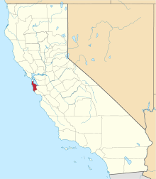 | |
| CDPs | ||
| Unincorporated communities | ||
| Ghost towns | ||
