Rajiv Gandhi Salai
 49A
| |
|---|---|
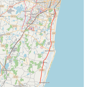 Rajiv Gandhi Salai (SH 49A) highlighted in red | |
| Route information | |
| Maintained by Tamil Nadu Road Development Corporation | |
| Length | 43.7 km[1] (27.2 mi) |
| Existed | 29 October 2008 – present |
| Highway system | |
State Highway 49A[1] also known as Rajiv Gandhi Salai[2] is a major road connecting Chennai, Tamil Nadu with Mahabalipuram in Kanchipuram district, Tamil Nadu. It is 45 km long and was earlier known as the Old Mahabalipuram Road (OMR). The road starts from Madhya Kailash Temple on Sardar Patel Road in South-East Chennai and terminates on East Coast Road near Mahabalipuram.
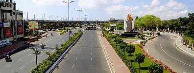
The prestigious TIDEL Park, home to a number of BPO and IT/ITES companies and many other major IT/ITES Companies in the country are situated along the Rajiv Gandhi Salai. Prominent technical and educational Institutions, national research laboratories are also located along the Corridor.
Besides, State Industries Promotion Corporation of Tamil Nadu Ltd (SIPCOT) has developed a Cyber City, spread over 2000 acres in Siruseri, abutting the IT Corridor. Many IT/ITES Companies have set up their facilities in the Cyber City[2].
Toll plazas
There are two toll plazas on OMR and three on the roads leading to OMR.
- Entrance toll plaza at Seevaram (Perungudi)
- Exit plaza at Egattur
- Satellite toll plaza on 200 feet Thoraipakkam-Pallavaram radial road
- Satellite toll plaza on Sholinganallur-Medavakkam link road
- Satellite toll plaza on Sholinganallur-ECR link road (Kalaignar Karunanidhi Salai)
Gallery


See also
References
External links
| Wikimedia Commons has media related to Old Mahabalipuram Road. |
- The Federation of OMR Residents Associations
- "the Road to The future" - IT Corridor (home page)
- Newindpress - One for the Road
- SIPCOT IT Park map
| National Highways | ||
|---|---|---|
| State Highways | ||
| Companies and organisations |
| ||||||||
|---|---|---|---|---|---|---|---|---|---|
| Airports |
| ||||||||
| Rail Transport |
| ||||||||
| Roads |
| ||||||||
| Water/Sea Transport | |||||||||
| |||||||||
| Transport by cities | |||||||||
|---|---|---|---|---|---|---|---|---|---|
| Road |
| ||||||||
| Rail |
| ||||||||
| Air |
| ||||||||
| Water |
| ||||||||
Coordinates: 12°58′33″N 80°15′04″E / 12.975897°N 80.251018°E