Petrovac, Bosnia and Herzegovina
| Petrovac Петровац | ||
|---|---|---|
| Village and municipality | ||
| ||
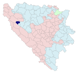 Location of Petrovac within Republika Srpska | ||
| Coordinates: 44°30′N 16°28′E / 44.500°N 16.467°E | ||
| Country | Bosnia and Herzegovina | |
| Entity | Republika Srpska | |
| Geographical region | Krajina | |
| Government | ||
| • Mayor | Dejan Prošić (DNS) | |
| Area | ||
| • Total | 154.9 km2 (59.8 sq mi) | |
| Population (2013 census) | ||
| • Total | 361 | |
| • Density | 2.3/km2 (6.0/sq mi) | |
| Time zone | UTC+1 (CET) | |
| • Summer (DST) | UTC+2 (CEST) | |
| Area code(s) | 51 | |
| Website |
www | |
Petrovac (Serbian Cyrillic: Петровац) is a village and municipality located in Republika Srpska, an entity of Bosnia and Herzegovina. It is situated in the western part of Republika Srpska and the central part of the Krajina region. Petrovac was created from a small part of the pre-war municipality of Bosanski Petrovac, whose remaining portion kept the original name and is a part of the Federation of Bosnia and Herzegovina.[1] The municipality seat is in Drinić.
Geography
Petrovac is a rural municipality, consisting of villages Bunara, Drinić and Podsrnetica.[2] It is located between municipalities of Bosanski Petrovac (BIH Federation) in the north and west, Ribnik and Istočni Drvar in the east, and Drvar in the south. The total area of the municipality is 137 km², about a sixth of 853 km² of the pre-war municipality. It is bordered by rivers of Una, Sana and Unca (river).[3]
Demographics
According to the 2013 census results, the municipality of Petrovac has 361 inhabitants.
See also
References
- ↑ Official Government of Bosnia and Herzegovina page regarding the use of both names
- ↑ "Općina Bosanski Petrovac". Vlada Unsko-Sanskog Kantona.
- ↑ Geographic Location, Official Homepage of the municipality of Petrovac