Randolph Township, Ohio County, Indiana
| Randolph Township | |
|---|---|
| Township | |
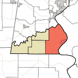 Location in Ohio County | |
| Coordinates: 38°56′47″N 84°53′45″W / 38.94639°N 84.89583°WCoordinates: 38°56′47″N 84°53′45″W / 38.94639°N 84.89583°W | |
| Country |
|
| State |
|
| County | Ohio |
| Government | |
| • Type | Indiana township |
| Area | |
| • Total | 38.54 sq mi (99.8 km2) |
| • Land | 37.34 sq mi (96.7 km2) |
| • Water | 1.21 sq mi (3.1 km2) 3.14% |
| Elevation | 518 ft (158 m) |
| Population (2010) | |
| • Total | 4,383 |
| • Density | 117.4/sq mi (45.3/km2) |
| ZIP codes | 47001, 47040 |
| GNIS feature ID | 453780 |
Randolph Township is one of four townships in Ohio County, Indiana, United States. As of the 2010 census, its population was 4,383 and it contained 2,033 housing units.[1]
Geography
According to the 2010 census, the township has a total area of 38.54 square miles (99.8 km2), of which 37.34 square miles (96.7 km2) (or 96.89%) is land and 1.21 square miles (3.1 km2) (or 3.14%) is water.[1] The Ohio River defines the township's eastern border.
Cities, towns, villages
Unincorporated towns
- Buffalo at 39°01′14″N 84°53′02″W / 39.020614°N 84.883839°W
- Camp Shor at 38°59′53″N 84°50′57″W / 38.998115°N 84.849116°W
- Norths Landing at 38°54′08″N 84°52′25″W / 38.902283°N 84.873560°W
(This list is based on USGS data and may include former settlements.)
Cemeteries
The township contains these three cemeteries: Cedar Hedge, LaGrange and Rising Sun.
Major highways
School districts
- Rising Sun-Ohio County Community Schools
Political districts
- State House District 68
- State Senate District 43
References
- "Randolph Township, Ohio County, Indiana". Geographic Names Information System. United States Geological Survey. Retrieved 2009-10-22.
- United States Census Bureau 2009 TIGER/Line Shapefiles
- IndianaMap
- 1 2 "Population, Housing Units, Area, and Density: 2010 - County -- County Subdivision and Place -- 2010 Census Summary File 1". United States Census. Retrieved 2013-05-10.
External links
- Indiana Township Association
- United Township Association of Indiana
- City-Data.com page for Randolph Township
Places adjacent to Randolph Township, Ohio County, Indiana | |
|---|---|
Municipalities and communities of Ohio County, Indiana, United States | ||
|---|---|---|
| City | ||
| Townships | ||
| Unincorporated communities | ||
This article is issued from
Wikipedia.
The text is licensed under Creative Commons - Attribution - Sharealike.
Additional terms may apply for the media files.