O'Brien County, Iowa
| O'Brien County, Iowa | |
|---|---|
 | |
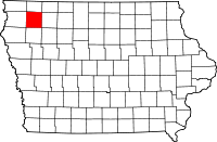 Location in the U.S. state of Iowa | |
 Iowa's location in the U.S. | |
| Founded | 1851 |
| Named for | William Smith O'Brien |
| Seat | Primghar |
| Largest city | Sheldon |
| Area | |
| • Total | 573 sq mi (1,484 km2) |
| • Land | 573 sq mi (1,484 km2) |
| • Water | 0.2 sq mi (1 km2), 0.03% |
| Population | |
| • (2010) | 14,398 |
| • Density | 25/sq mi (10/km2) |
| Congressional district | 4th |
| Time zone | Central: UTC−6/−5 |
| Website |
www |
O'Brien County is a county located in the U.S. state of Iowa. As of the 2010 census, the population was 14,398.[1] The county seat is Primghar.[2]
History
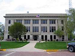
O'Brien County was founded in 1851.[3] The county was named for William Smith O'Brien, a leader for Irish independence in 1848.[4] The present courthouse was completed in 1917,[5] and is listed on the National Register of Historic Places.
Geography
According to the U.S. Census Bureau, the county has a total area of 573 square miles (1,480 km2), of which 573 square miles (1,480 km2) is land and 0.2 square miles (0.52 km2) (0.03%) is water.[6]
Major highways
Adjacent counties
- Osceola County (north)
- Clay County (east)
- Cherokee County (south)
- Sioux County (west)
Demographics
| Historical population | |||
|---|---|---|---|
| Census | Pop. | %± | |
| 1860 | 383 | — | |
| 1870 | 715 | 86.7% | |
| 1880 | 4,155 | 481.1% | |
| 1890 | 13,060 | 214.3% | |
| 1900 | 16,985 | 30.1% | |
| 1910 | 17,262 | 1.6% | |
| 1920 | 19,051 | 10.4% | |
| 1930 | 18,409 | −3.4% | |
| 1940 | 19,293 | 4.8% | |
| 1950 | 18,970 | −1.7% | |
| 1960 | 18,840 | −0.7% | |
| 1970 | 17,522 | −7.0% | |
| 1980 | 16,972 | −3.1% | |
| 1990 | 15,444 | −9.0% | |
| 2000 | 15,102 | −2.2% | |
| 2010 | 14,398 | −4.7% | |
| Est. 2016 | 14,020 | [7] | −2.6% |
| U.S. Decennial Census[8] 1790-1960[9] 1900-1990[10] 1990-2000[11] 2010-2013[1] | |||

As of the census[12] of 2010, there were 14,398 people, 6,069 households, and 3,927 families residing in the county. The population density was 25.1239/sq mi (9.7004/km2). There were 6,649 housing units at an average density of 11 per square mile (4/km²). The racial makeup of the county was 96.0% White, 0.5% Black or African American, 0.1% American Indian, 0.6% Asian, 2.0% from other races, and 0.8% from two or more races. The county has a 3.8% Hispanic or Latino background.
There were 6,069 households out of which 26.0% had children under the age of 18 living with them, 55.1% were married couples living together, 6.1% had a female householder with no husband present, 3.5% had a male householder with no wife present, and 35.3% were non-families. 31.5% of all households were made up of individuals living alone and 33.1% had someone living alone who was 65 years of age or older. The average household size was 2.31 and the average family size was 2.89.
In the county, the population was spread out with 25.7% under the age of 20, 4.6% from 20 to 24, 21.3% from 25 to 44, 28.1% from 45 to 64, and 20.4% who were 65 years of age or older. The median age was 43.6 years. For every 100 females there were 95.80 males. For every 100 females, there were 99.1 males.
The median income for a household in the county was $44,018, and the median income for a family was $58,127. The per capita income for the county was $24,771. About 6.3% of families and 11.0% of the population were below the poverty line, including 15.7% of those under age 18 and 8.3% of those age 65 or over.[13]
Communities
Cities
Unincorporated communities
Townships
Population ranking
The population ranking of the following table is based on the 2010 census of O'Brien County.[14]
† county seat
| Rank | City/Town/etc. | Municipal type | Population (2010 Census)
|
|---|---|---|---|
| 1 | Sheldon (partially in Sioux County) | City | 5,188 |
| 2 | Hartley | City | 1,672 |
| 3 | Sanborn | City | 1,404 |
| 4 | Paullina | City | 1,056 |
| 5 | † Primghar | City | 909 |
| 6 | Sutherland | City | 649 |
| 7 | Calumet | City | 170 |
| 8 | Archer | City | 131 |
Politics
| Year | Republican | Democratic | Third Parties |
|---|---|---|---|
| 2016 | 77.7% 5,752 | 17.8% 1,315 | 4.6% 339 |
| 2012 | 71.7% 5,266 | 26.8% 1,969 | 1.4% 106 |
| 2008 | 66.7% 4,894 | 31.9% 2,338 | 1.4% 101 |
| 2004 | 68.9% 5,328 | 30.1% 2,330 | 0.9% 73 |
| 2000 | 66.4% 4,674 | 30.8% 2,170 | 2.8% 200 |
| 1996 | 57.6% 3,877 | 33.2% 2,236 | 9.2% 622 |
| 1992 | 51.1% 3,869 | 28.0% 2,122 | 21.0% 1,587 |
| 1988 | 60.0% 4,241 | 39.1% 2,768 | 0.9% 63 |
| 1984 | 66.2% 5,008 | 32.8% 2,479 | 1.1% 82 |
| 1980 | 63.6% 4,937 | 28.5% 2,210 | 7.9% 614 |
| 1976 | 61.9% 4,643 | 36.4% 2,732 | 1.8% 131 |
| 1972 | 68.9% 5,159 | 29.7% 2,224 | 1.4% 108 |
| 1968 | 69.3% 5,594 | 26.6% 2,146 | 4.1% 328 |
| 1964 | 50.2% 4,336 | 49.7% 4,295 | 0.1% 6 |
| 1960 | 68.7% 6,509 | 31.3% 2,967 | 0.0% 4 |
| 1956 | 67.3% 6,138 | 32.6% 2,970 | 0.1% 10 |
| 1952 | 76.2% 7,130 | 23.4% 2,192 | 0.4% 38 |
| 1948 | 50.5% 3,697 | 46.7% 3,421 | 2.8% 208 |
| 1944 | 56.0% 4,033 | 43.6% 3,138 | 0.4% 30 |
| 1940 | 53.3% 4,760 | 46.3% 4,133 | 0.4% 38 |
| 1936 | 38.9% 3,350 | 59.7% 5,139 | 1.4% 123 |
| 1932 | 40.9% 3,213 | 57.4% 4,503 | 1.7% 132 |
| 1928 | 66.4% 4,845 | 32.8% 2,397 | 0.8% 56 |
| 1924 | 58.5% 4,172 | 10.6% 756 | 30.9% 2,207 |
| 1920 | 76.5% 5,137 | 21.9% 1,468 | 1.6% 109 |
| 1916 | 52.5% 2,021 | 46.5% 1,787 | 1.0% 39 |
| 1912 | 16.0% 620 | 38.9% 1,506 | 45.1% 1,744 |
| 1908 | 57.7% 1,912 | 40.0% 1,326 | 2.3% 76 |
| 1904 | 68.9% 2,279 | 26.8% 885 | 4.3% 142 |
| 1900 | 61.2% 2,386 | 37.5% 1,461 | 1.4% 54 |
| 1896 | 60.1% 2,421 | 38.8% 1,562 | 1.1% 45 |
See also
References
- 1 2 "State & County QuickFacts". United States Census Bureau. Archived from the original on July 15, 2011. Retrieved July 20, 2014.
- ↑ "Find a County". National Association of Counties. Retrieved 2011-06-07.
- ↑ Columbia-Lippincott Gazetteer, (New York:Columbia University Press, 1952), p. 1363
- ↑ Chicago and North Western Railway Company (1908). A History of the Origin of the Place Names Connected with the Chicago & North Western and Chicago, St. Paul, Minneapolis & Omaha Railways. p. 162.
- ↑ "O'Brien County Courthouse". Iowa Judicial Branch. Archived from the original on 2012-04-01. Retrieved 2011-03-07.
- ↑ "US Gazetteer files: 2010, 2000, and 1990". United States Census Bureau. 2011-02-12. Retrieved 2011-04-23.
- ↑ "Population and Housing Unit Estimates". Retrieved June 9, 2017.
- ↑ "U.S. Decennial Census". United States Census Bureau. Retrieved July 20, 2014.
- ↑ "Historical Census Browser". University of Virginia Library. Retrieved July 20, 2014.
- ↑ "Population of Counties by Decennial Census: 1900 to 1990". United States Census Bureau. Retrieved July 20, 2014.
- ↑ "Census 2000 PHC-T-4. Ranking Tables for Counties: 1990 and 2000" (PDF). United States Census Bureau. Retrieved July 20, 2014.
- ↑ "American FactFinder". United States Census Bureau. Retrieved 2008-01-31.
- ↑ "Population and Housing Occupancy Status: 2010 - State -- County". United States Census Bureau American FactFinder. Retrieved March 26, 2011.
- ↑ https://www.census.gov/2010census/
- ↑ Leip, David. "Dave Leip's Atlas of U.S. Presidential Elections". uselectionatlas.org. Retrieved 2018-04-27.
External links
| Wikimedia Commons has media related to O'Brien County, Iowa. |
- O'Brien County Portal style website, Government, Business, Tourism and more
- IaGenWeb O'Brien county history, Biographies, and more
- City-Data Comprehensive Statistical Data and more about O'Brien County
Places adjacent to O'Brien County, Iowa | ||||||||||
|---|---|---|---|---|---|---|---|---|---|---|
| ||||||||||
Municipalities and communities of O'Brien County, Iowa, United States | ||
|---|---|---|
| Cities | ||
| Townships | ||
| Other unincorporated communities | ||
| Footnotes | ‡This populated place also has portions in an adjacent county or counties | |

Coordinates: 43°04′53″N 95°37′34″W / 43.08139°N 95.62611°W