List of districts of Chhattisgarh
Chhattisgarh, a state of India, has 27 administrative districts.
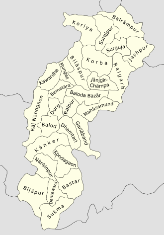
At the time of separation from Madhya Pradesh, Chhattisgarh originally had 16 districts. Two new districts: Bijapur and Narayanpur were carved out on May 11, 2007[1] and nine new districts on Jan 1, 2012. The new districts have been created by carving out the existing districts to facilitate more targeted, focused and closer administration. These districts have been named Sukma, Kondagaon, Balod, Bemetara, Baloda Bazar, Gariaband, Mungeli, Surajpur and Balrampur[2]
Background
A district of an Indian state is an administrative geographical unit, headed by a district magistrate or a deputy commissioner, an officer belonging to the Indian Administrative Service. The district magistrate or the deputy commissioner is assisted by a number of officials belonging to different wings of the administrative services of the state.
A superintendent of Police, an officer belonging to Indian Police Service is entrusted with the responsibility of maintaining law and order and related issues.
Administrative history
Before Indian independence, present-day Chhattisgarh state was divided between the Central Provinces and Berar, a province of British India, and a number of princely states in the north, south, and east, which were part of the Eastern States Agency.
The British province encompassed the central portion of the state, and was made up of three districts, Raipur, Bilaspur, and Durg, which made up the Chhattisgarh Division of the Central Provinces. Durg District was created in 1906 out of the eastern portion of Raipur District.
The northern portion of the state, comprising present-day Koriya, Surajpur, Surguja, Jashpur, and Raigarh districts, was divided among the six princely states of Chang Bhakar, Jashpur, Koriya, Surajpur, Raigarh, Surguja, and Udaipur. To the east the states of Nandgaon, Khairagarh, and Kawardha comprised parts of present-day Rajnandgaon and Kawardha districts. In the south, the state of Kanker comprised the northern portion of present-day Kanker District, and the state of Bastar included present-day Bastar and Dantewada districts and the southern part of Kanker District.
After Indian Independence, the princely states were merged with the Central Provinces and Berar to form the new state of Madhya Pradesh. Present-day Chhattisgarh comprised seven districts of Madhya Pradesh. The former states of Kanker and Bastar formed the new Bastar District, the parts of Surguja, Korea, and Chang Bhakar formed the new Surguja District, and the states of Nandgaon, Khairagarh, and Kawardha formed the new Rajnandgaon District.
In 1998, the seven districts that make up present-day Chhattisgarh were reorganized to form 16 districts. Dantewada and Kanker districts were split from Bastar; Dhamtari District was split from Raipur; Janjgir-Champa and Korba districts were split from Bilaspur; Jashpur District was split from Raigarh; Kawardha District was formed from parts of Bilaspur and Rajnandgaon; Koriya and Surajpur District was split from Surguja; and Mahasamund District was split from Raipur.
On November 1, 2000 these 16 districts were split from Madhya Pradesh to form the new state of Chhattisgarh.[3] Two New Districts Are Added Afterwards. On January 1, 2012 Chhattisgarh Government announced 9 New Districts. Total No. of Districts in Chhattisgarh is now 27.
Districts of Chhattisgarh
Following the creation of new districts in 2012, Chhattisgarh consists of 27 districts.[2][4][5][6][7]
Districts grouped by divisions
Surguja Division:
Bilaspur Division:
Durg Division:
Raipur Division:
Bastar Division:
District with their major cities
See also
References
- ↑ "2 new districts formed in Chhattisgarh". May 12, 2007.
- 1 2 Anita (2 January 2012). "Chhattisgarh gets New Year gift - 9 new districts!". Oneindia. Retrieved 16 February 2016.
- ↑ Creation of Chhattisgarh Government of Chhattisgarh.
- ↑ "Electoral rolls". Office of the Chief Electoral Officer, Chhattisgarh. Archived from the original on 2012-03-05.
- ↑ Chhattisgarh at a glance-2002 Archived 2012-04-04 at the Wayback Machine. Govt. of Chhattisgarh ofiicial website.
- ↑ List of Chhattisgarh District Centres Archived 2012-02-20 at the Wayback Machine. at NIC, Chhattisgarh official Portal
- ↑ Mathew, K.M. (ed.). Manorama Yearbook 2008, Kottayam: Malayala Manorama, ISSN 0542-5778, p.518
Further reading
- Alanga, Sanjaya. छत्तीसगढ़ की पूर्व रियासतें और जमीन्दारियाँ [The former princely states of Chhattisgarh and Jmindariya] (in Hindi). Raipur: Vaibhav Prakashan. ISBN 81-89244-96-5.
- Alanga, Sanjaya. Chattīsagaṛha kī janajātiyām̐ aura jātiyām̐ [Tribes and castes of Chhattīsgarh] (in Hindi). Delhi: Mansi Publication. ISBN 978-81-89559-32-8.
External links
- Districts of Chhattisgarh
- Chhattisgarh Photos, Videos, Maps and Tourism
- List of Chhattisgarh District Centres at Chhattisgarh Official Portal.
- List of District official websites
| States | ||
|---|---|---|
| Union Territories | ||
| Related topics | ||
| Governance |  | |
|---|---|---|
| Topics | ||
| Districts | ||
| Cities | ||
| ||