Monroe County, New York
| Monroe County, New York | ||
|---|---|---|
| County of New York State | ||
| County of Monroe | ||
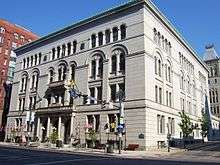 Monroe County Office Building | ||
| ||
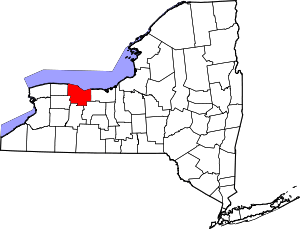 Location in the U.S. state of New York | ||
 New York's location in the U.S. | ||
| Founded | February 23, 1821 | |
| Named for | James Monroe | |
| Seat | Rochester | |
| Largest city | Rochester | |
| Area | ||
| • Total | 1,367 sq mi (3,541 km2) | |
| • Land | 657 sq mi (1,702 km2) | |
| • Water | 710 sq mi (1,839 km2), 52% | |
| Population (est.) | ||
| • (2017) |
| |
| • Density | 1,133/sq mi (437/km2) | |
| Congressional districts | 25th, 27th | |
| Time zone | Eastern: UTC−5/−4 | |
| Website |
www | |

Monroe County is a county in the western portion of the state of New York, in the United States. The county is along Lake Ontario's southern shore. As of 2017, Monroe County's population was 747,642.[1] Its county seat is the city of Rochester.[2] The county is named after James Monroe, the fifth President of the United States.[3] Monroe County is part of the Rochester, NY Metropolitan Statistical Area.
History
When counties were established in the Province of New York in 1683, the present Monroe County was part of Albany County. This was an enormous county, including the northern part of New York State as well as all of the present State of Vermont and, in theory, extending westward to the Pacific Ocean. This county was reduced in size on July 3, 1766 by the creation of Cumberland County, and further on March 16, 1770 by the creation of Gloucester County, both containing territory now in Vermont.
On March 12, 1772, what was left of Albany County was split into three parts, one remaining under the name Albany County. One of the other pieces, Tryon County, contained the western portion (and thus, since no western boundary was specified, theoretically still extended west to the Pacific). The eastern boundary of Tryon County was approximately five miles west of the present city of Schenectady, and the county included the western part of the Adirondack Mountains and the area west of the West Branch of the Delaware River. The area then designated as Tryon County now includes 37 counties of New York State. The county was named for William Tryon, colonial governor of New York.
In the years prior to 1776, most of the Loyalists in Tryon County fled to Canada. In 1784, following the peace treaty that ended the American Revolutionary War, the name of Tryon County was changed to Montgomery County in order to honor the general, Richard Montgomery, who had captured several places in Canada and died attempting to capture the city of Quebec, replacing the name of the hated British governor.
In 1789, Ontario County was split off from Montgomery. The actual area split off from Montgomery County was much larger than the present county, also including the present Allegany, Cattaraugus, Chautauqua, Erie, Genesee, Livingston, Monroe, Niagara, Orleans, Steuben, Wyoming, Yates, and part of Schuyler and Wayne counties.
Genesee County was created by a splitting of Ontario County in 1802. This was much larger than the present Genesee County, however. It contained the present Allegany, Cattaraugus, Chautauqua, Erie, Niagara, Orleans, Wyoming, and portions of Livingston and Monroe counties.
Finally, Monroe County was formed from parts of Genesee and Ontario counties in 1821.
Geography
According to the U.S. Census Bureau, the county's total area is 1,367 square miles (3,540 km2), of which 657 square miles (1,700 km2) is land and 710 square miles (1,800 km2) (52%) is water.[4]
Monroe County is in Western New York State's northern tier, northeast of Buffalo and northwest of Syracuse. The northern county line is also the state line and the border of the United States, marked by Lake Ontario. Monroe County is north of the Finger Lakes.
Adjacent counties
- Wayne County - east
- Ontario County - southeast
- Livingston County - south
- Orleans County - west
- Genesee County - southwest
Major highways


Government and politics
| Year | Republican | Democratic | Third Parties |
|---|---|---|---|
| 2016 | 39.3% 136,582 | 54.2% 188,592 | 6.5% 22,616 |
| 2012 | 40.0% 133,362 | 58.0% 193,501 | 2.1% 6,950 |
| 2008 | 40.5% 144,262 | 58.2% 207,371 | 1.3% 4,791 |
| 2004 | 47.7% 163,545 | 50.6% 173,497 | 1.8% 6,022 |
| 2000 | 44.5% 141,266 | 50.9% 161,743 | 4.7% 14,816 |
| 1996 | 37.3% 115,694 | 53.2% 164,858 | 9.5% 29,442 |
| 1992 | 39.4% 134,021 | 41.6% 141,502 | 19.1% 64,846 |
| 1988 | 49.9% 155,271 | 49.3% 153,650 | 0.8% 2,545 |
| 1984 | 57.8% 182,696 | 41.8% 132,109 | 0.5% 1,472 |
| 1980 | 41.9% 128,615 | 46.4% 142,423 | 11.6% 35,695 |
| 1976 | 55.1% 167,303 | 44.4% 134,739 | 0.5% 1,392 |
| 1972 | 62.0% 196,579 | 37.8% 120,031 | 0.2% 695 |
| 1968 | 48.3% 143,233 | 47.7% 141,437 | 4.1% 12,085 |
| 1964 | 28.1% 80,099 | 71.9% 205,226 | 0.1% 257 |
| 1960 | 51.2% 148,423 | 48.8% 141,378 | 0.1% 147 |
| 1956 | 66.8% 183,747 | 33.2% 91,161 | 0.0% 0 |
| 1952 | 58.9% 159,172 | 41.0% 110,723 | 0.1% 370 |
| 1948 | 48.1% 109,608 | 48.6% 110,641 | 3.3% 7,544 |
| 1944 | 48.1% 111,725 | 51.5% 119,672 | 0.4% 876 |
| 1940 | 48.5% 114,383 | 51.1% 120,613 | 0.5% 1,099 |
| 1936 | 44.2% 93,055 | 54.3% 114,286 | 1.5% 3,182 |
| 1932 | 51.6% 95,964 | 44.8% 83,208 | 3.7% 6,788 |
| 1928 | 55.7% 99,803 | 41.2% 73,759 | 3.1% 5,516 |
| 1924 | 57.1% 80,577 | 20.5% 28,956 | 22.4% 31,595 |
| 1920 | 63.8% 73,809 | 24.7% 28,523 | 11.6% 13,389 |
| 1916 | 61.7% 39,393 | 34.1% 21,782 | 4.2% 2,688 |
| 1912 | 31.5% 16,880 | 33.3% 17,863 | 35.2% 18,834[6] |
| 1908 | 56.7% 33,250 | 38.7% 22,704 | 4.6% 2,695 |
| 1904 | 60.3% 30,772 | 32.4% 16,544 | 7.3% 3,737 |
| 1900 | 54.6% 26,691 | 40.1% 19,611 | 5.3% 2,568 |
| 1896 | 58.7% 26,288 | 38.3% 17,158 | 3.1% 1,372 |
| 1892 | 51.4% 21,327 | 42.7% 17,706 | 5.9% 2,455 |
| 1888 | 54.6% 21,650 | 42.0% 16,677 | 3.4% 1,361 |
| 1884 | 54.9% 18,325 | 39.7% 13,249 | 5.4% 1,812 |
County government
Monroe County was chartered as a municipal corporation by the New York State Legislature in 1892[7] and re-chartered under New York's Municipal Home Rule Law in 1965.[8]
Executive branch
The county's executive branch is headed by the County Executive, Cheryl Dinolfo.[9] The executive's office is on the first floor of the County Office Building on West Main Street in Rochester.
The county was exclusively governed by a Board of Supervisors for the first 114 years of its history. In 1935, the position of County Manager, appointed by the Board, was approved by popular referendum.[10] In 1983, the position was replaced by a County Executive, directly elected by popular vote, with expanded powers (e.g., veto).[11] In 1993, the legislature enacted term limits for the executive office of 12 consecutive years to start in 1996.[12]
| Name | Title | Party | Term |
|---|---|---|---|
| Clarence A. Smith | County Manager | Republican | January 1, 1936 – December 31, 1959 |
| Gordon A. Howe | County Manager | Republican | January 1, 1960 – December 31, 1971 |
| Lucien A. Morin | County Manager County Executive | Republican | January 18, 1972 – December 31, 1982 January 1, 1983 – December 31, 1986 |
| Thomas R. Frey | County Executive | Democrat | January 1, 1987 – December 31, 1991 |
| Robert L. King | County Executive | Republican | January 1, 1992 – January 14, 1995 |
| John D. "Jack" Doyle | County Executive | Republican | January 14, 1995 – December 31, 2003 |
| Maggie Brooks | County Executive | Republican | January 1, 2004 – December 31, 2015 |
| Cheryl L. Dinolfo | County Executive | Republican | January 1, 2016 – present |
Legislative branch
The county's legislative branch consists of a 29-member County Legislature which replaced the earlier 43-member Board of Supervisors on January 1, 1967.[13] It meets in the Legislative Chambers on the fourth floor of the County Office Building. All 29 members of the legislature are elected from districts. District Maps Currently, there are 19 Republicans and 10 Democrats. In 1993, the legislature enacted term limits of 10 consecutive years to start in 1996.[14]
Judicial branch
- Monroe County Court
- Monroe County Family Court, for matters involving children
- Monroe County Surrogates Court, for matters involving the deceased
- Rochester City Court
Representation at the federal level
After redistricting based on the 2010 United States Census, Monroe County was split between two congressional districts:
| District | Areas of Monroe County | Congressperson | Party | First took office | Residence |
|---|---|---|---|---|---|
| New York's 25th congressional district | All of Monroe County except those portions represented by the 27th district[15] | Vacant | Democratic | — | — |
| New York's 27th congressional district | Hamlin, Mendon, Rush, Wheatland, and the southwest corner of Clarkson[16] | Christopher C. Collins | Republican | 2013 | Clarence, Erie County |
Representation at the state level
New York State Senate
After redistricting based on the 2010 United States Census, Monroe County was split between six state senate districts:
| District | Areas of Monroe County | Senator | Party | First took office | Residence |
|---|---|---|---|---|---|
| 54 | Webster[17] | Pam Helming | Republican | 2017 | Canandaigua, Ontario County |
| 55 | East Rochester, Irondequoit, Mendon, Penfield, Perinton, Pittsford, Rush, northeastern part of the City of Rochester[18] | Rich Funke | Republican | 2015 | Fairport, Monroe County |
| 56 | Brighton, Clarkson, Gates, Greece, Hamlin, Parma, northwestern part of the City of Rochester[19] | Joseph E. Robach | Republican | 2003 | Greece, Monroe County |
| 59 | Henrietta, Wheatland[20] | Patrick M. Gallivan | Republican | 2011 | Elma, Erie County |
| 61 | Chili, Riga, southern part of the City of Rochester[21] | Michael H. Ranzenhofer | Republican | 2009 | Amherst, Erie County |
| 62 | Ogden, Sweden[22] | George D. Maziarz | Republican | 1995 | Newfane, Niagara County |
New York State Assembly
After redistricting based on the 2010 United States Census, Monroe County was split between seven state assembly districts:
| District | Areas of Monroe County | Assemblyperson | Party | First took office | Residence |
|---|---|---|---|---|---|
| 133 | Mendon, Pittsford, Riga, Rush, Wheatland[23] | Joseph Errigo | Republican | 2017 | Monroe County |
| 134 | Greece, Ogden, Parma[24] | Peter Lawrence | Republican | 2003 | Greece, Monroe County |
| 135 | East Rochester, Penfield, Perinton, Webster[25] | Mark C. Johns | Republican | 2011 | Webster, Monroe County |
| 136 | Brighton, Irondequoit, northwest portion and easternmost tip of the City of Rochester[26] | Joseph D. Morelle | Democratic | 1991 | Irondequoit, Monroe County |
| 137 | Gates, center of the City of Rochester[27] | David F. Gantt | Democratic | 1983 | Rochester, Monroe County |
| 138 | Chili, Henrietta, parts of the City of Rochester[28] | Harry B. Bronson | Democratic | 2011 | Rochester, Monroe County |
| 139 | Clarkson, Hamlin, Sweden[29] | Stephen M. Hawley | Republican | 2006 | Batavia, Genesee County |
Courts
Monroe County is part of
- The 7th Judicial District of the New York Supreme Court.
- The 4th Division of the New York Supreme Court, Appellate Division
Economy
Monroe County is a home to a number of international businesses, including Eastman Kodak,[30] Paychex,[31] and Pictometry International,[32] all of which make Monroe County their world headquarters. While longer headquartered in Rochester, Xerox has its principal offices and manufacturing facilities in Monroe County (Xerox 2010 Annual Report), and Bausch and Lomb was headquartered in Rochester until it was acquired by Valeant Pharmaceuticals. Monroe County is also home to regional businesses such as Wegmans,[33] Roberts Communications, Inc.,[34] Holding Corp.,[35] and major fashion label Hickey Freeman.[36]
High technology
Tech Valley, the technologically recognized area of eastern New York State, has spawned a western offshoot into the Rochester, Monroe County, and Finger Lakes areas of New York State. Since the 2000s, as the more established companies in Rochester downsized, the economy of Rochester and Monroe County has been redirected toward high technology, with new, smaller companies providing the seed capital necessary for business foundation. The Rochester and Monroe County area is important in the field of photographic processing and imaging as well as incubating an increasingly diverse high technology sphere encompassing STEM fields, in part the result of private startup enterprises collaborating with major academic institutions, including the University of Rochester and Cornell University.[37] Given the high prevalence of imaging and optical science among the industry and the universities, Rochester is known as the world capital of imaging. The Institute of Optics of the University of Rochester and the Rochester Institute of Technology in nearby Henrietta both have imaging programs.[38] In 2006, the University of Rochester became the largest employer in the Rochester area, surpassing the Eastman Kodak Company.[39]
Demographics
| Historical population | |||
|---|---|---|---|
| Census | Pop. | %± | |
| 1830 | 49,855 | — | |
| 1840 | 64,902 | 30.2% | |
| 1850 | 87,650 | 35.0% | |
| 1860 | 100,648 | 14.8% | |
| 1870 | 117,868 | 17.1% | |
| 1880 | 144,903 | 22.9% | |
| 1890 | 189,586 | 30.8% | |
| 1900 | 217,854 | 14.9% | |
| 1910 | 283,212 | 30.0% | |
| 1920 | 352,034 | 24.3% | |
| 1930 | 423,881 | 20.4% | |
| 1940 | 438,230 | 3.4% | |
| 1950 | 487,632 | 11.3% | |
| 1960 | 586,387 | 20.3% | |
| 1970 | 711,917 | 21.4% | |
| 1980 | 702,238 | −1.4% | |
| 1990 | 713,968 | 1.7% | |
| 2000 | 735,343 | 3.0% | |
| 2010 | 744,344 | 1.2% | |
| Est. 2017 | 747,642 | [40] | 0.4% |
| U.S. Decennial Census[41] 1790-1960[42] 1900-1990[43] 1990-2000[44] 2010-2013[1] | |||
As of the census of 2000, there were 735,343 people, 286,512 households, and 184,513 families residing in the county. The population density was 1,115 people per square mile (431/km²). There were 304,388 housing units at an average density of 462 per square mile (178/km²). The county's racial makeup was 79.14% White, 13.75% African American, 0.27% Native American, 2.44% Asian, 0.03% Pacific Islander, 2.44% from other races, and 1.94% from two or more races. Hispanic or Latino of any race were 5.31% of the population. 18.6% were of Italian, 15.3% German, 11.3% Irish and 8.3% English ancestry according to Census 2000. 4.64% of the population reported speaking Spanish at home, while 1.43% speak Italian.[45]
There were 286,512 households out of which 31.80% had children under the age of 18 living with them, 47.40% were married couples living together, 13.40% had a female householder with no husband present, and 35.60% were non-families. 28.60% of all households were made up of individuals and 9.90% had someone living alone who was 65 years of age or older. The average household size was 2.47 and the average family size was 3.08.
In the county, the population was spread out with 25.60% under the age of 18, 9.50% from 18 to 24, 29.30% from 25 to 44, 22.60% from 45 to 64, and 13.00% who were 65 years of age or older. The median age was 36 years. For every 100 females there were 93.00 males. For every 100 females age 18 and over, there were 89.20 males.
The median income for a household in the county was $44,891, and the median income for a family was $55,900. Males had a median income of $41,279 versus $29,553 for females. The per capita income for the county was $22,821. About 8.20% of families and 11.20% of the population were below the poverty line, including 15.50% of those under age 18 and 7.40% of those age 65 or over.
Education
Primary and secondary education
The public school system educates the overwhelming majority of Monroe County's children. The schools operated by the Roman Catholic Diocese of Rochester or Roman Catholic religious orders educate the next largest segment of children, although collectively, they are a distant second.
Public schools
There are some 26 public school districts that serve Monroe County, including the Rochester City School District, 10 suburban school districts in Monroe #1 BOCES, seven in Monroe #2–Orleans BOCES, and several primarily serving other counties (Avon, Byron–Bergen, Caledonia–Mumford, Holley, Wayne, Williamson and Victor central school districts).[46]
| Name | BOCES | Established | District population | Professional staff | Support staff | Median teacher salary | Enrollment | Budget | Per pupil cost |
|---|---|---|---|---|---|---|---|---|---|
| Brighton Central School District | Monroe #1 | 1966 | 26450 | 372 | 293 | $63580 | 3681 | $74.0 million | $18444 |
| Brockport Central School District | Monroe #2–Orleans | 1927 | 30000 | 356 | 362 | $59971 | 3411 | $78.9 million | $23128 |
| Churchville-Chili Central School District | Monroe #2–Orleans | 1950 | 30000 | 350 | 322 | $59752 | 3845 | $82.6 million | $21523 |
| East Irondequoit Central School District | Monroe #1 | 1956 | 27000 | 335 | 352 | $56447 | 3145 | $76.3 million | $24257 |
| East Rochester Union Free School District | Monroe #1 | 1920 | 8200 | 125 | 91 | $53829 | 1179 | $27.4 million | $23282 |
| Fairport Central School District | Monroe #1 | 1951 | 40000 | 645 | 516 | $65630 | 5905 | $123.3 million | $20874 |
| Gates Chili Central School District | Monroe #2–Orleans | 1956 | 35000 | 451 | 402 | $61423 | 4123 | $100.8 million | $24459 |
| Greece Central School District | Monroe #2–Orleans | 1928 | 96000 | 1127 | 1249 | $72100 | 11094 | $221.2 million | $19941 |
| Hilton Central School District | Monroe #2–Orleans | 1949 | 25323 | 421 | 367 | $60407 | 4452 | $80.0 million | $17965 |
| Holley Central School District | Monroe #2–Orleans | 1949 | 7774 | 125 | 87 | $53366 | 1051 | $24.4 million | $23216 |
| Honeoye Falls-Lima Central School District | Monroe #1 | 1969 | 10500 | 219 | 205 | $62074 | 2212 | $48.5 million | $19542 |
| Kendall Central School District | Monroe #2–Orleans | 1957 | 3000 | 86 | 76 | $53551 | 704 | $17.4 million | $22269 |
| Penfield Central School District | Monroe #1 | 1948 | 31000 | 438 | 477 | $61612 | 4564 | $93.3 million | $20445 |
| Pittsford Central School District | Monroe #1 | 1946 | 33000 | 575 | 656 | $67848 | 5685 | $125.5 million | $22280 |
| Rochester City School District | None | 1841 | 209000 | 5786 (total) | 5786 (total) | $61617 | 30217 | $864.7 million | $21546 |
| Rush-Henrietta Central School District | Monroe #1 | 1947 | 46000 | 613 | 603 | $63344 | 5247 | $119.9 million | $22838 |
| Spencerport Central School District | Monroe #2–Orleans | 1949 | 23000 | 408 | 351 | $62348 | 3584 | $77.1 million | $21521 |
| Webster Central School District | Monroe #1 | 1948 | 54093 | 801 | 631 | $66408 | 8549 | $163.9 million | $19167 |
| West Irondequoit Central School District | Monroe #1 | 1953 | 23754 | 344 | 258 | $59855 | 3568 | $71.2 million | $19916 |
| Wheatland–Chili Central School District | Monroe #2–Orleans | 1955 | 5100 | 80 | 63 | $54967 | 691 | $17.8 million | $23837 |
Private schools
There are three private schools that serve more than 200 students each:
- Allendale Columbia School, a college preparatory school in Pittsford
- The Harley School, a college preparatory school in Brighton
- Mary Cariola Children's Center serving children with multiple, complex disabilities in the city
There is one small, but historically significant school: Rochester School for the Deaf in the city
Parochial schools
- There are three small Judaic schools and two small Islamic schools.
- There are about ten primary schools operated by the Roman Catholic Diocese of Rochester.
- There are four senior high schools (or combined junior/senior high schools) operated by or in the tradition of a Roman Catholic religious order:
School Founding religious order Location Established Grades Aquinas Institute Basilian City of Rochester 1902 6–12 Bishop Kearney High School Christian Brothers, Sisters of Notre Dame Irondequoit 1962 6–12 McQuaid Jesuit High School Jesuits Brighton 1954 6–12 Our Lady of Mercy High School Sisters of Mercy Brighton 1928 6–12
- There are more than two dozen schools operated by various sects of Christianity, two of which serve more than 200 students:
School Religious affiliation Location Established Grades The Charles Finney School Non-denominational Christian Penfield 1992 K–12 Northstar Christian Academy Baptist Gates 1972 K–12
Colleges and universities
The county is home to nine colleges and universities:
- Bryant & Stratton College in Greece and Henrietta
- Colgate Rochester Crozer Divinity School in the city
- Monroe Community College in Brighton with a campus in the city
- Nazareth College in Pittsford
- Roberts Wesleyan College in Chili
- Rochester Institute of Technology in Henrietta
- St. Bernard's School of Theology and Ministry in Pittsford
- St. John Fisher College in Pittsford
- State University of New York at Brockport in Brockport with a campus in the city
- University of Rochester in the city
Additionally, four colleges maintain satellite campuses in Monroe County:
- The Cornell University School of Industrial and Labor Relations maintains an office in the city[48]
- Empire State College maintains the Genesee Valley Learning Center in Irondequoit[49]
- Ithaca College's Department of Physical Therapy leases part of the Colgate Rochester Crozer Divinity School facility for teaching and research[50]
- Medaille College maintains its Rochester Campus in Brighton[51]
Parks

- Abraham Lincoln Park
- Arrow Park
- Black Creek Park
- Churchville Park
- Devil's Cove Park
- Durand Eastman Park
- Ellison Park
- Genesee Valley Park
- Greece Canal Park
- Highland Park
- Irondequoit Bay Marine Park
- Irondequoit Bay Park West
- Lehigh Valley Trail Park
- Mendon Ponds Park
- Northampton Park
- Oatka Creek Park
- Ontario Beach Park
- Powder Mills Park
- Seneca Park
- Tryon Park
- Ronald Webster Park
- Wetlands Park
Communities
_-_Towns%2C_Villages%2C_and_City.svg.png)
City
- Rochester (county seat)
Towns
Villages
Villages in New York State are incorporated municipalities located within Towns. The town in which each village is located is noted in parenthesis.
- Brockport (Sweden)
- Churchville (Riga)
- East Rochester (Coterminous village and town)
- Fairport (Perinton)
- Hilton (Parma)
- Honeoye Falls (Mendon)
- Pittsford (Pittsford)
- Scottsville (Wheatland)
- Spencerport (Ogden)
- Webster (Webster)
Census-designated places
Hamlets
In New York State the term "Hamlet", although not defined in law, is used to describe an unincorporated community and geographic location within a town. The town in which each Hamlet is located is in parenthesis.
- Genesee Junction (Chili)
- Egypt (Perinton)
- Adams Basin (Ogden)
- Bushnell's Basin (Perinton)
- Gates Center (Gates)
- Garbutt (Scottsville)
- Mumford (Wheatland)
- Union Hill (Webster)
- Mendon Center (Mendon)
- Seabreeze (Irondequoit)
- Summerville (Irondequoit)
- Parma Center (Parma)
- Riga Center (Riga)
- Sweden Center (Sweden)
- West Webster (Webster)
- North Chili (Chili)
- Clarkson Corners (Clarkson)
- Gates Center (Gates)
- North Gates (Gates)
- Clifton (Chili)
- Industry (Rush)
- Belcoda (Wheatland)
- Coldwater (Gates)
- Barnard (Greece)
- Beattie Beach (Greece)
- Braddock Bay (Greece)
- Braddock Heights (Greece)
- Elmgrove (Greece)
- Grandview Heights (Greece)
- Grand View Beach (Greece)
- North Greece (Greece)
- Ridgemont (Greece)
- West Greece (Greece)
Notable residents
See also
References
- 1 2 "State & County QuickFacts". United States Census Bureau. Archived from the original on July 15, 2011. Retrieved October 12, 2013.
- ↑ "Find a County". National Association of Counties. Retrieved 2011-06-07.
- ↑ Gannett, Henry (1905). The Origin of Certain Place Names in the United States. U.S. Government Printing Office. p. 212.
- ↑ "2010 Census Gazetteer Files". United States Census Bureau. August 22, 2012. Archived from the original on May 19, 2014. Retrieved January 5, 2015.
- ↑ http://uselectionatlas.org/RESULTS
- ↑ There were only 14,919 votes for the leading "other" candidate, Progressive Theodore Roosevelt, plus 2,943 for Socialist Eugene Debs, 705 for the Prohibition Party's Eugene Chafin, and 267 for Socialist Labor candidate Arthur Reimer.
- ↑ "Governing Monroe County: A Staff Report to the Charter Study Commission". Rochester, New York: The Center for Governmental Research. 1974. p. 15. OCLC 21663493. External link in
|publisher=(help); Missing or empty|url=(help) - ↑ "Governing Monroe County: A Staff Report to the Charter Study Commission". Rochester, New York: The Center for Governmental Research. 1974. p. 25. OCLC 21663493. External link in
|publisher=(help); Missing or empty|url=(help) - ↑ "Monroe County Executive website". Retrieved 2008-06-22.
- ↑ "Monroe County Guide to Local Government". Rochester, New York: Monroe County League of Women Voters. 1986: 10. OCLC 13907929.
- ↑ "Monroe County Guide to Local Government". Rochester, New York: Monroe County League of Women Voters. 1986: 11. OCLC 13907929.
- ↑ "Monroe limits legislator terms". Democrat and Chronicle. Rochester, New York. 1993-11-03. p. 1A. ISSN 1088-5153
- ↑ "Monroe County Guide to Local Government". Rochester, New York: Monroe County League of Women Voters. 1986: 10. OCLC 13907929.
- ↑ "Monroe limits legislator terms". Democrat and Chronicle. Rochester, New York. 1993-11-03. p. 1A. ISSN 1088-5153
- ↑ W, Eric (2012-04-02). "Congressional District 25" (PDF). View 2012 Congressional Maps. Albany, New York: The New York State Legislative Task Force on Demographic Research and Reapportionment. Retrieved 2013-01-06.
- ↑ W, Eric (2012-04-02). "Congressional District 27" (PDF). View 2012 Congressional Maps. Albany, New York: The New York State Legislative Task Force on Demographic Research and Reapportionment. Retrieved 2013-01-06.
- ↑ W, Eric (2012-03-02). "Senate District 54" (PDF). View 2012 Senate District Maps. Albany, New York: The New York State Legislative Task Force on Demographic Research and Reapportionment. Retrieved 2013-01-06.
- ↑ W, Eric (2012-03-02). "Senate District 55" (PDF). View 2012 Senate District Maps. Albany, New York: The New York State Legislative Task Force on Demographic Research and Reapportionment. Retrieved 2013-01-06.
- ↑ W, Eric (2012-03-02). "Senate District 56" (PDF). View 2012 Senate District Maps. Albany, New York: The New York State Legislative Task Force on Demographic Research and Reapportionment. Retrieved 2013-01-06.
- ↑ W, Eric (2012-03-02). "Senate District 59" (PDF). View 2012 Senate District Maps. Albany, New York: The New York State Legislative Task Force on Demographic Research and Reapportionment. Retrieved 2013-01-06.
- ↑ W, Eric (2012-03-02). "Senate District 61" (PDF). View 2012 Senate District Maps. Albany, New York: The New York State Legislative Task Force on Demographic Research and Reapportionment. Retrieved 2013-01-06.
- ↑ W, Eric (2012-03-02). "Senate District 62" (PDF). View 2012 Senate District Maps. Albany, New York: The New York State Legislative Task Force on Demographic Research and Reapportionment. Retrieved 2013-01-06.
- ↑ W, Eric (2012-01-25). "Assembly District 133" (PDF). View Proposed 2012 Assembly District Maps. Albany, New York: The New York State Legislative Task Force on Demographic Research and Reapportionment. Retrieved 2017-03-06.
- ↑ W, Eric (2012-01-25). "Assembly District 134" (PDF). View Proposed 2012 Assembly District Maps. Albany, New York: The New York State Legislative Task Force on Demographic Research and Reapportionment. Retrieved 2013-01-06.
- ↑ W, Eric (2012-01-25). "Assembly District 135" (PDF). View Proposed 2012 Assembly District Maps. Albany, New York: The New York State Legislative Task Force on Demographic Research and Reapportionment. Retrieved 2013-01-06.
- ↑ W, Eric (2012-01-25). "Assembly District 136" (PDF). View Proposed 2012 Assembly District Maps. Albany, New York: The New York State Legislative Task Force on Demographic Research and Reapportionment. Retrieved 2013-01-06.
- ↑ W, Eric (2012-01-25). "Assembly District 137" (PDF). View Proposed 2012 Assembly District Maps. Albany, New York: The New York State Legislative Task Force on Demographic Research and Reapportionment. Retrieved 2013-01-06.
- ↑ W, Eric (2012-01-25). "Assembly District 138" (PDF). View Proposed 2012 Assembly District Maps. Albany, New York: The New York State Legislative Task Force on Demographic Research and Reapportionment. Retrieved 2013-01-06.
- ↑ W, Eric (2012-01-25). "Assembly District 139" (PDF). View Proposed 2012 Assembly District Maps. Albany, New York: The New York State Legislative Task Force on Demographic Research and Reapportionment. Retrieved 2013-01-06.
- ↑ "Eastman Kodak Company information and related industry information from Hoover's". Hoover's, Inc. 2007. Retrieved 2007-04-25.
- ↑ "Paychex, Inc. information and related industry information from Hoover's". Hoover's, Inc. 2007. Retrieved 2007-04-25.
- ↑ "Business briefs". Rochester Democrat and Chronicle (http://www.democratandchronicle.com/apps/pbcs.dll/article?AID=20107070338)
|format=requires|url=(help). 2010-07-07.Dick Kaplan announced his resignation as CEO of Pictometry International Corp., the Henrietta-based aerial imaging firm that he has built into one of the Rochester area’s better-known companies.
- ↑ "Wegmans Food Markets, Inc. information and related industry information from Hoover's". Hoover's. 2007. Retrieved 2007-04-25.
- ↑ "Roberts Communications, Inc. information and related industry information from Hoover's". Hoover's, Inc. 2007. Retrieved 2007-04-25.
- ↑ Daneman, Matthew (2010-08-06). "PAETEC cuts loss to $7.5M". Democrat and Chronicle. Retrieved 2010-08-11.
PAETEC Holding Corp. is edging closer to — but still falling short of — profitability. The Perinton-based telecommunications company reported a loss of $7.5 million for the quarter that ended June 30, an improvement from the $16.5 million it lost in the same quarter a year earlier and from the $9.5 million it lost in the January–March quarter this year.
- ↑ "Hickey-Freeman Co., Inc. information and related industry information from Hoover's". Hoover's, Inc. 2008. Retrieved 2008-02-08.
- ↑ "High Tech Rochester adds 4 businesses". Rochester Democrat and Chronicle. November 7, 2013. Retrieved October 29, 2015.
- ↑ The Society for Imaging Science and Technology Archived 2015-10-16 at the Wayback Machine., The Society for Imaging Science and Technology website
- ↑ Economic Development, University of Rochester "Connections" website
- ↑ "Population and Housing Unit Estimates". Retrieved June 9, 2017.
- ↑ "U.S. Decennial Census". United States Census Bureau. Retrieved January 5, 2015.
- ↑ "Historical Census Browser". University of Virginia Library. Retrieved January 5, 2015.
- ↑ "Population of Counties by Decennial Census: 1900 to 1990". United States Census Bureau. Retrieved January 5, 2015.
- ↑ "Census 2000 PHC-T-4. Ranking Tables for Counties: 1990 and 2000" (PDF). United States Census Bureau. Retrieved January 5, 2015.
- ↑ "MLA Language Map Data Center: Monroe County, New York". Modern Language Association. 2007. Retrieved 2007-04-25.
- ↑ Facts and Figures on Monroe County School Districts, Brighton, New York: Monroe County School Boards Association, 2017, pp. back flap, OCLC 4891330, archived from the original on 2013-01-06
- ↑ Facts and Figures on Monroe County School Districts, Brighton, New York: Monroe County School Boards Association, 2017, pp. 18–55, OCLC 4891330, archived from the original on 2013-01-06
- ↑ "Rochester Regional Office". Ithaca, New York: Cornell University. Retrieved 2011-12-21.
- ↑ "Rochester Location". Saratoga, New York: Empire State College. Archived from the original on 2012-01-23. Retrieved 2011-12-21.
- ↑ "Rochester Center". Ithaca, New York: Ithaca College. Retrieved 2011-12-21.
Ithaca College maintains a teaching and research facility in Rochester, NY on the campus of the Colgate Rochester Crozier Divinity School (CRCDS on South Goodman St. at Highland Ave.) and is affiliated with the University of Rochester and Strong Memorial Hospital.
- ↑ "Rochester Campus". Buffalo, New York: Medaille College. Archived from the original on 2011-12-31. Retrieved 2011-12-21.
We are located at 1880 South Winton Road, situated near Rochester's Outer Loop
Further reading
- Sherwood, D.A. (2003). Water resources of Monroe County, New York, water years 1997-99, with emphasis on water quality in the Irondequoit Creek basin : atmospheric deposition, ground water, streamflow, trends in water quality, and chemical loads to Irondequoit Bay [Water-Resources Investigations Report 02-4221]. Ithaca, NY: U.S. Department of the Interior, U.S. Geological Survey.
- Raines, Thomas, [et al.] (1895). Landmarks of Monroe County, New York. Boston: The Boston History Company. Retrieved 2013-11-10.
- Federal Writers' Project. New York (State) (1937). Rochester and Monroe County. Rochester, NY: Scrantom's. Retrieved 2013-11-11.
External links
- Official webpage
- Monroe County at Curlie (based on DMOZ)
- Monroe County Library System
- Rochester Wiki Monroe County Page
- Monroe County Parks Department
- The Roman Catholic Diocese of Rochester, New York
Places adjacent to Monroe County, New York | ||||||||||
|---|---|---|---|---|---|---|---|---|---|---|
| ||||||||||
Municipalities and communities of Monroe County, New York, United States | ||
|---|---|---|
| City | | |
| Towns | ||
| Villages | ||
| CDPs | ||
| Other hamlets | ||
| Footnotes | ‡This populated place also has portions in an adjacent county or counties | |

Coordinates: 43°18′N 77°41′W / 43.30°N 77.69°WWhile
| Authority control |
|---|