Orleans County, New York
| Orleans County, New York | ||
|---|---|---|
| County of New York State | ||
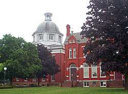 County courthouse and clerk's office in Albion | ||
| ||
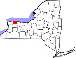 Location in the U.S. state of New York | ||
 New York's location in the U.S. | ||
| Founded | 1824 | |
| Named for | House of Orléans | |
| Seat | Albion | |
| Largest town | Albion | |
| Area | ||
| • Total | 817 sq mi (2,116 km2) | |
| • Land | 391 sq mi (1,013 km2) | |
| • Water | 426 sq mi (1,103 km2), 52% | |
| Population | ||
| • (2017) |
| |
| • Density | 110/sq mi (40/km2) | |
| Congressional district | 27th | |
| Time zone | Eastern: UTC−5/−4 | |
| Website |
www | |

Orleans County is a county in the western part of the U.S. state of New York. As of the 2010 census, the population was 42,883.[1] The county seat is Albion.[2] The county received its name at the insistence of Nehemiah Ingersoll[3] though historians are unsure how the name was selected.[4] The two competing theories are that it was named to honor the French Royal House of Orleans or that it was to honor Andrew Jackson's victory in New Orleans.[4]
Located on the south shore of Lake Ontario, Orleans County since the late 20th century has been considered part of the Rochester, NY Metropolitan Statistical Area.
History
When counties were established by the British authorities in the province of New York in 1683, the present Orleans County was part of the territory of Albany County. This was an enormous county, including the northern part of present-day New York State as well as all of the present State of Vermont and, in theory, extending westward to the Pacific Ocean. This county was reduced in size on July 3, 1766 by the creation of Cumberland County, and further on March 16, 1770 by the creation of Gloucester County, both containing territory now in Vermont.
On March 12, 1772, the remaining Albany County was split into three parts, one remaining under the name Albany County. Tryon County contained the large western portion (and thus, since no western boundary was specified, theoretically still extended west to the Pacific). The eastern boundary of Tryon County was approximately five miles west of the present city of Schenectady, and the county included the Mohawk River valley, the western part of the Adirondack Mountains and the area west of the West Branch of the Delaware River. The area then designated as Tryon County now includes 37 counties of New York State. The county was named for William Tryon, colonial governor of New York. This western area was occupied largely by the Onondaga, Oneida and other western nations of the Iroquois Confederacy. The westernmost European settlements were in the area of Little Falls and present-day Herkimer.
During the unrest prior to the outbreak of the American Revolutionary War, feelings ran high in the Mohawk Valley, and there were local attacks by rebels against known Loyalists. Most of Tryon County's Loyalists fled to Canada before 1776, where they were later granted land by the Crown to develop what is now Ontario.
In 1784, following the peace treaty that ended the American Revolutionary War, Tryon County's name was changed to Montgomery County to honor the general, Richard Montgomery. He had captured several places in Canada and died attempting to capture the city of Quebec. It replaced the name of the now hated colonial British governor. In 1789, Ontario County split off from Montgomery.[5] During this period, thousands of migrants settled in the western part of the state from New England and eastern New York resulting in the creation of more counties.
In 1802, Genesee County was created by splitting Ontario County.[5] Genesee County was then divided into Allegany County in 1806, Cattaraugus, Chautauqua, and Niagara Counties in 1808, Ontario, Livingston, and Monroe Counties in 1821, and finally Orleans County in 1824.
When Orleans County was formed in 1824,[6] a dispute arose about naming it after President Andrew Jackson or President John Adams.[4] The conflict was ended by choosing the name of the French Royal House of Orléans. During and following the Napoleonic era in France, numerous French refugees came to New York, some settling in the upstate areas.
Geography
According to the U.S. Census Bureau, the county has a total area of 817 square miles (2,120 km2), of which 391 square miles (1,010 km2) is land and 426 square miles (1,100 km2) (52%) is water.[7]
The high proportion of water is due to the extension of Orleans County north into Lake Ontario to the Canada–US border (a line of latitude running through the middle of the lake). The distance from the Orleans shore north to the international border is greater than the distance from the shore south to the Genesee County line, meaning the area of Orleans under water is greater than that above water.
Orleans County is in western New York State, northeast of Buffalo and west of Rochester, on the southern shore of Lake Ontario.
The Erie Canal passes (east–west) through the middle of the county. When its construction was completed in 1824, it attracted new settlers to the largely rural county. Trade and passenger traffic stimulated the development of local businesses.
Adjacent counties
- Monroe County - east
- Genesee County - south
- Niagara County - west
Major highways
National protected area
State protected areas
- Lakeside Beach State Park
- Oak Orchard State Marine Park
- Oak Orchard Wildlife Management Area
- Tonawanda Wildlife Management Area
| Year | Republican | Democratic | Third Parties |
|---|---|---|---|
| 2016 | 66.8% 10,936 | 27.3% 4,470 | 6.0% 974 |
| 2012 | 58.4% 8,594 | 39.4% 5,787 | 2.2% 325 |
| 2008 | 58.5% 9,708 | 39.9% 6,614 | 1.6% 262 |
| 2004 | 62.2% 10,317 | 36.0% 5,959 | 1.8% 301 |
| 2000 | 58.1% 9,202 | 37.8% 5,991 | 4.1% 651 |
| 1996 | 45.0% 6,865 | 40.8% 6,233 | 14.2% 2,170 |
| 1992 | 44.6% 7,468 | 29.4% 4,927 | 26.0% 4,359 |
| 1988 | 60.0% 9,028 | 39.3% 5,913 | 0.8% 114 |
| 1984 | 70.2% 10,543 | 29.5% 4,429 | 0.4% 52 |
| 1980 | 51.6% 7,536 | 39.5% 5,767 | 9.0% 1,308 |
| 1976 | 59.9% 8,994 | 39.5% 5,927 | 0.7% 102 |
| 1972 | 71.4% 10,938 | 28.5% 4,371 | 0.1% 20 |
| 1968 | 60.7% 8,509 | 34.1% 4,786 | 5.2% 729 |
| 1964 | 37.4% 5,567 | 62.5% 9,304 | 0.2% 25 |
| 1960 | 65.2% 10,344 | 34.8% 5,515 | 0.0% 5 |
| 1956 | 77.5% 11,895 | 22.6% 3,464 | 0.0% 0 |
| 1952 | 75.0% 11,686 | 25.0% 3,893 | 0.1% 8 |
| 1948 | 69.2% 9,566 | 29.0% 4,009 | 1.9% 259 |
| 1944 | 71.3% 9,998 | 28.6% 4,006 | 0.2% 22 |
| 1940 | 70.6% 10,958 | 29.2% 4,525 | 0.2% 36 |
| 1936 | 70.5% 10,569 | 26.8% 4,016 | 2.7% 409 |
| 1932 | 68.0% 9,735 | 30.1% 4,303 | 2.0% 283 |
| 1928 | 68.8% 9,828 | 26.5% 3,792 | 4.7% 672 |
| 1924 | 71.9% 8,543 | 19.5% 2,320 | 8.6% 1,017 |
| 1920 | 72.8% 8,305 | 19.9% 2,266 | 7.4% 839 |
| 1916 | 64.4% 4,903 | 33.2% 2,529 | 2.4% 180 |
| 1912 | 41.4% 2,983 | 33.9% 2,448 | 24.7% 1,781 |
| 1908 | 62.3% 4,885 | 33.0% 2,590 | 4.7% 365 |
| 1904 | 63.5% 5,027 | 31.6% 2,502 | 4.9% 389 |
| 1900 | 59.1% 4,667 | 36.1% 2,851 | 4.7% 373 |
| 1896 | 59.0% 4,664 | 37.8% 2,993 | 3.2% 252 |
| 1892 | 52.3% 4,013 | 39.9% 3,065 | 7.8% 596 |
| 1888 | 52.0% 4,277 | 39.1% 3,214 | 9.0% 737 |
| 1884 | 52.3% 3,997 | 38.0% 2,907 | 9.7% 737 |
Government and politics
Starting in 1824, the county government was run by a board of supervisors, consisting of elected supervisors from each township in Orleans County. This geographic representation meant that the residents of more urbanized areas were underrepresented on the board.
In 1980, the state and county established a seven-member elected legislature to replace the board of supervisors. Representatives are elected from single-member districts roughly equal in population. It is headed by a chairman.
Orleans County is heavily Republican. It has voted Republican in every presidential election since the party's founding in 1856, except for one, 1964. It also voted Whig in every election from 1828 until 1852.
County government
Orleans County legislature
| Office | District | Area of the county | Officeholder | Party | Residence |
|---|---|---|---|---|---|
| County Legislator | District 1 | Barre, Clarendon, Shelby | William H. Eick | Republican | Medina |
| County Legislator - Chairwoman | District 2 | Ridgeway, Yates | Lynne M. Johnson | Republican | Lyndonville |
| County Legislator - Minority Leader | District 3 | Albion, Gaines | Fred Miller | Democratic | Albion |
| County Legislator | District 4 | Carlton, Kendall, Murray | Kenneth DeRoller | Republican | Kendall |
| County Legislator | At Large | All | Merle L. "Skip" Draper | Republican | Shelby |
| County Legislator - Vice Chairman | At Large | All | Don Allport | Republican | Albion |
| County Legislator | At Large | All | E. John DeFilipps | Republican | Holley |
Orleans County elected officials
| Office | Officeholder | Party |
|---|---|---|
| County Judge | Sanford A. Church | Republican |
| District Attorney | Joseph V. Cardone | Republican |
| County Clerk | Karen A. Lake-Maynard | Republican |
| County Treasurer | Kimberly C. L. DeFrank | Republican |
| Chief Coroner | Scott M. Schmidt | Republican |
| Coroner | Rocco L. Sidari | Republican |
| Coroner | Charles M. Smith | Republican |
State and federal government
| Office | District | Officeholder | Party | First took office | Residence |
|---|---|---|---|---|---|
| Congressman | New York's 27th congressional district | Christopher C. Collins | Republican | 2013 | Clarence, Erie County |
| State Senator | 62nd State Senate District | Rob Ortt | Republican | 2015 | , Niagara County |
| State Assemblyman | 139th State Assembly District | Stephen M. Hawley | Republican | 2006 | Batavia, Genesee County |
Orleans County is part of:
- The 8th Judicial District of the New York Supreme Court
- The 4th Division of the New York Supreme Court, Appellate Division
Demographics
| Historical population | |||
|---|---|---|---|
| Census | Pop. | %± | |
| 1830 | 17,732 | — | |
| 1840 | 25,127 | 41.7% | |
| 1850 | 28,501 | 13.4% | |
| 1860 | 28,717 | 0.8% | |
| 1870 | 27,689 | −3.6% | |
| 1880 | 30,128 | 8.8% | |
| 1890 | 30,803 | 2.2% | |
| 1900 | 30,164 | −2.1% | |
| 1910 | 32,000 | 6.1% | |
| 1920 | 28,619 | −10.6% | |
| 1930 | 28,795 | 0.6% | |
| 1940 | 27,760 | −3.6% | |
| 1950 | 29,832 | 7.5% | |
| 1960 | 34,159 | 14.5% | |
| 1970 | 37,305 | 9.2% | |
| 1980 | 38,496 | 3.2% | |
| 1990 | 41,846 | 8.7% | |
| 2000 | 44,171 | 5.6% | |
| 2010 | 42,883 | −2.9% | |
| Est. 2017 | 40,983 | [9] | −4.4% |
| U.S. Decennial Census[10] 1790-1960[11] 1900-1990[12] 1990-2000[13] 2010-2013[1] | |||
As of the census[14] of 2010[15], there were 42,883 people, 16,119 households, and 10,872 families residing in the county. The population density was 113 people per square mile (44/km²). There were 17,347 housing units at an average density of 44 per square mile (17/km²). The racial makeup of the county was 89.8% White, 5.9% Black or African American, 0.6% Native American, 0.4% Asian, 0.0% Pacific Islander, 1.3% from other races, and 1.9% from two or more races. 4.1% of the population were Hispanic or Latino of any race. According to Census 2000, 20.3% were of German, 18.3% English, 10.8% Italian, 10.3% Irish, 9.4% American and 7.3% Polish ancestry and 96.0% spoke English and 3.0% Spanish as their first language.
Census 2010 showed there were 16,119 households out of which 31.2% had children under the age of 18 living with them, 49% were married couples living together, 12.4% had a female householder with no husband present, and 32.6% were non-families. 26.2% of all households were made up of individuals and 11% had someone living alone who was 65 years of age or older. The average household size was 2.5 and the average family size was 2.99.
In the county, the population was spread out with 19.8% under the age of 18, 8.8% from 18 to 24, 24.2% from 25 to 44, 29.8% from 45 to 64, and 17.40% who were 65 years of age or older. The median age was 41 years.
The median income for a household in the county was $48,731. Males had a median income of $32,450 versus $22,605 for females. The per capita income for the county was $16,457. About 15.2% of the population were below the poverty line.
Education
Public schools
The county has five school districts, although the actual district boundaries can extend into neighboring counties, and the same is true for neighboring counties' districts. The five districts, from west to east,[16] are:
- Lyndonville Central School District (northern half of western third, roughly covering Lyndonville village and the towns of Yates and Ridgeway)
- Medina Central School District (southern half of western third, roughly covering Medina village and the towns of Ridgeway and Shelby)
- Albion Central School District (middle third, roughly covering Albion village and the towns of Carlton, Gaines, Albion, and Barre)
- Kendall Central School District (northern half of eastern third, roughly covering the towns of Kendall and Murray)
- Holley Central School District (southern half of eastern third, roughly covering Holley village and the towns of Murray and Clarendon)
Each of these school districts participates in Orleans/Niagara BOCES.[17]
Private school
There is currently one non-denominational K-12 school in the county.
- Orleans County Christian School[18]
College
One college maintains satellite campuses in Orleans County.[16]
- Genesee Community College - Albion
- Genesee Community College - Medina
Recreation
Libraries
Orleans County has 4 public libraries serving its population.[19]
- Community Free Library, located in Holley
- Hoag Library, located in Albion
- Lee-Whedon Memorial Library, located in Medina
- Yates Community Library, located in Lyndonville
Museums
Orleans County has 3 museums that are open to the public.
- The Cobblestone Museum
- Medina Railroad Museum
- Oak Orchard Lighthouse Museum
Parks
There are two State Parks and many municipal parks spread throughout the county.
Communities
_-_Towns_and_Villages.svg.png)
Towns
Villages
- Albion (county seat)
- Holley
- Lyndonville
- Medina
Hamlets
- Ashwood
- Barre Center
- Brockville
- Childs
- County Line
- Eagle Harbor
- East Shelby
- Fancher
- Hindsburg
- Hulberton
- Jeddo
- Kendall Mills
- Kenyonville
- Knowlesville
- Kuckville
- Millers
- Millville
- Oak Orchard
- Sawyer
- Shelby Center
- Yates Center
See also
References
- 1 2 "State & County QuickFacts". United States Census Bureau. Archived from the original on July 16, 2011. Retrieved October 12, 2013.
- ↑ "Find a County". National Association of Counties. Archived from the original on May 31, 2011. Retrieved 2011-06-07.
- ↑ Lattin, C.W. (23 January 1981). "Early County History - Part II". Journal-Register.
- 1 2 3 Lattin, Cary (1976). Orleans County History. Albion, NY: Eddy Printing Corp. p. 20.
- 1 2 Signor, Issac (1894). Landmarks of Orleans County New York. Syracuse, NY: D. Mason & Company. p. 1.
- ↑ Signor, Isaac (1894). Landmarks of Orleans County New York. Syracuse, NY: D. Mason & Company. pp. 2–5.
- ↑ "2010 Census Gazetteer Files". United States Census Bureau. August 22, 2012. Archived from the original on May 19, 2014. Retrieved January 6, 2015.
- ↑ http://uselectionatlas.org/RESULTS
- ↑ "Population and Housing Unit Estimates". Retrieved June 9, 2017.
- ↑ "U.S. Decennial Census". United States Census Bureau. Archived from the original on May 12, 2015. Retrieved January 6, 2015.
- ↑ "Historical Census Browser". University of Virginia Library. Retrieved January 6, 2015.
- ↑ "Population of Counties by Decennial Census: 1900 to 1990". United States Census Bureau. Retrieved January 6, 2015.
- ↑ "Census 2000 PHC-T-4. Ranking Tables for Counties: 1990 and 2000" (PDF). United States Census Bureau. Retrieved January 6, 2015.
- ↑ "American FactFinder". United States Census Bureau. Retrieved 2008-01-31.
- ↑ "Orleans County, New York". American Fact Finder. Retrieved 27 June 2018.
- 1 2 "Orleans County Visitors". Orleans County New York. Retrieved 27 Oct 2017.
- ↑ "Component Districts". Orleans/Niagara BOCES. Archived from the original on 2003-12-05. Retrieved 27 Oct 2017.
- ↑ "Orleans County Christian School". Orleans County Christian School. Retrieved 27 Oct 2017.
- ↑ "NIOGA Library System". New York State Library. Retrieved 30 Oct 2017.
External links
- Official Webpage
- Orleans County at Curlie (based on DMOZ)

- Genesee Community College in Orleans County
- Brief historical summary of Orleans County, NY
Coordinates: 43°22′N 78°14′W / 43.37°N 78.23°W
Places adjacent to Orleans County, New York | ||||||||||
|---|---|---|---|---|---|---|---|---|---|---|
| ||||||||||
Municipalities and communities of Orleans County, New York, United States | ||
|---|---|---|
| Towns | | |
| Villages | ||
| Hamlets | ||
| Footnotes | ‡This populated place also has portions in an adjacent county or counties | |