Franklin County, New York
| Franklin County, New York | ||
|---|---|---|
| County of New York State | ||
| County of Franklin | ||
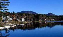
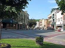 Broadway Street, in Saranac Lake | ||
| ||
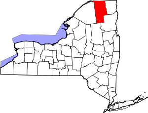 Location in the U.S. state of New York | ||
 New York's location in the U.S. | ||
| Founded | 1808 | |
| Named for | Benjamin Franklin | |
| Seat | Malone | |
| Largest town | Malone | |
| Area | ||
| • Total | 1,697 sq mi (4,395 km2) | |
| • Land | 1,629 sq mi (4,219 km2) | |
| • Water | 68 sq mi (176 km2), 4.0% | |
| Population | ||
| • (2010) | 51,599 | |
| • Density | 32/sq mi (12/km2) | |
| Congressional district | 21st | |
| Time zone | Eastern: UTC−5/−4 | |
| Website |
www | |

Franklin County is a county in the northern part of the U.S. state of New York. It borders the Canadian provinces of Quebec and Ontario. As of the 2010 census, the county population was 51,599.[1] Its county seat is Malone.[2] The county is named in honor of United States Founding Father Benjamin Franklin.[3]
Franklin County comprises the Malone, NY Micropolitan Statistical Area. Much of Franklin County is within Adirondack Park.
History
When counties were established by the English colonial government in New York in 1683, the present Franklin County was part of Albany County. This was an enormous county, including the northern part of New York State as well as all of the present State of Vermont and, in theory, extending westward to the Pacific Ocean. This county was reduced in size on July 3, 1766 by the creation of Cumberland County, and further on March 16, 1770 by the creation of Gloucester County, both containing territory now in Vermont. On March 12, 1772, what was left of Albany County was split into three parts, one remaining under the name Albany County. One of the other pieces, Charlotte County, contained the eastern portion.
In 1784, the name "Charlotte County" was changed to Washington County to honor George Washington, the American Revolutionary War general and later President of the United States of America.
In 1788, Clinton County was split off from Washington County. It comprised a much larger area than the present Clinton County, including several other counties or county parts of the present New York State.
Following the American Revolutionary War, the United States forced the Six Nations of the Haudenosaunee, or Iroquois Confederacy, to cede most of their lands in New York and Pennsylvania. Most of the nations had sided with Great Britain in the war. After the war, New York State sold off 5 million acres of former Iroquois territory at low-cost prices, seeking to attract settlers to develop farms and businesses. Land speculators quickly took advantage of the sales. Franklin County is part of the huge speculative Macomb's Purchase of 1791.
In 1799, Clinton County was reduced in size by the splitting off of Essex County. In 1802, Clinton County was reduced in size by a part of Clinton and two other counties being taken to form the new St. Lawrence County.
In 1808, Franklin County was split off from Clinton County and organized. It was named after United States Founding Father Benjamin Franklin.
In the late 1880s and 1890s, both the Delaware and Hudson and New York Central railroads were constructed into the Town of Franklin. The Chateaugay branch of the Delaware and Hudson served the hamlet of Onchiota, which developed for the lumber industry. For more than 12 years a major tract north of Saranac Lake was harvested and millions of feet of timber were shipped out from here.[4]
The railroads carried the timber and products to market, and the industry flourished into the early 20th century until much of the timber was harvested. Several lumber mills operated in this area for decades,[5] including Kinsley Lumber Company,[6] Baker Brothers Lumber Company,[7] and one owned by the Dock and Coal Company. The latter mill was dismantled in 1917 and shipped to Florida to be used in the lumber industry there.[4] The population declined as the lumber industry pulled out of the area.
The railroads also contributed to the Town of Franklin becoming a destination for summer travelers. In the late 1800s, Franklin County was home to three of the largest resort hotels in the Adirondacks: Paul Smith's Hotel, Loon Lake House, and Rainbow Inn. Due to the construction of highways and restructuring in the railroad industry, passenger service was ended to this remote area in the mid-20th century.[5]
The history of Franklin County is preserved at the Franklin Historical and Museum Society in Malone, New York.[8]
Ray Fadden (Mohawk), with his wife Christine and son John, was the founder and curator of the Six Nations Indian Museum located in Onchiota, a census-designated place in the Town of Franklin.[9] He built the structure from logs he had milled himself. The family-owned museum features more than 3,000 artifacts primarily from the Iroquoian nations, and interprets their culture.[10] They were a prominent confederacy in New York of Six Nations by 1722, and they controlled much of the state west of colonial settlements at Albany and Schenectady.
Geography
According to the U.S. Census Bureau, the county has a total area of 1,697 square miles (4,400 km2), of which 1,629 square miles (4,220 km2) is land and 68 square miles (180 km2) (4.0%) is water.[11] It is the fourth-largest county in New York by land area. Franklin County is in the northeastern part of New York State. The northern edge borders Quebec and Ontario provinces of Canada.
The Upper, Middle and Lower Saranac lakes are located within the county. These are part of the natural resource attractions in the area. Lower Saranac Lake extends into neighboring Essex County to the southeast. Loon Lake is also located in the county, as is its namesake community.
Adjacent counties and municipality
- Clinton County - east
- Essex County - southeast
- Hamilton County - southwest
- St. Lawrence County - west
- Stormont, Dundas and Glengarry United Counties, Ontario, Canada - northwest
- Le Haut-Saint-Laurent Regional County Municipality, Quebec, Canada - north
Demographics
| Historical population | |||
|---|---|---|---|
| Census | Pop. | %± | |
| 1810 | 2,617 | — | |
| 1820 | 4,439 | 69.6% | |
| 1830 | 11,312 | 154.8% | |
| 1840 | 16,518 | 46.0% | |
| 1850 | 25,102 | 52.0% | |
| 1860 | 30,837 | 22.8% | |
| 1870 | 30,271 | −1.8% | |
| 1880 | 32,390 | 7.0% | |
| 1890 | 38,110 | 17.7% | |
| 1900 | 42,853 | 12.4% | |
| 1910 | 45,717 | 6.7% | |
| 1920 | 43,541 | −4.8% | |
| 1930 | 45,694 | 4.9% | |
| 1940 | 44,286 | −3.1% | |
| 1950 | 44,830 | 1.2% | |
| 1960 | 44,742 | −0.2% | |
| 1970 | 43,931 | −1.8% | |
| 1980 | 44,929 | 2.3% | |
| 1990 | 46,540 | 3.6% | |
| 2000 | 51,134 | 9.9% | |
| 2010 | 51,599 | 0.9% | |
| Est. 2016 | 50,409 | [12] | −2.3% |
| U.S. Decennial Census[13] 1790-1960[14] 1900-1990[15] 1990-2000[16] 2010-2013[1] | |||
As of the census[17] of 2000, there were 51,134 people, 17,931 households, and 11,798 families residing in the county. The population density was 31 people per square mile (12/km²). There were 23,936 housing units at an average density of 15 per square mile (6/km²). The racial makeup of the county was 84.03% White, 6.63% Black or African American, 6.20% Native American, 0.38% Asian, 2.07% from other races, and 0.69% from two or more races. 4.01% of the population were Hispanic or Latino of any race. 31.0% were of French, 13.6% Irish, 10.6% American, 9.8% French Canadian, 9.2% English and 5.4% German ancestry according to Census 2000. 94.6% spoke English, 2.3% Spanish and 2.0% French as their first language.
There were 17,931 households out of which 32.20% had children under the age of 18 living with them, 49.50% were married couples living together, 11.10% had a female householder with no husband present, and 34.20% were non-families. 28.20% of all households were made up of individuals and 12.00% had someone living alone who was 65 years of age or older. The average household size was 2.46 and the average family size was 3.00.
In the county, the population was spread out with 22.80% under the age of 18, 9.50% from 18 to 24, 33.20% from 25 to 44, 21.80% from 45 to 64, and 12.80% who were 65 years of age or older. The median age was 36 years. For every 100 females there were 121.70 males. For every 100 females age 18 and over, there were 126.60 males.
The median income for a household in the county was $31,517, and the median income for a family was $38,472. Males had a median income of $29,376 versus $22,292 for females. The per capita income for the county was $15,888. About 10.10% of families and 14.60% of the population were below the poverty line, including 17.60% of those under age 18 and 13.90% of those age 65 or over.
Education
Franklin County is home to North Country Community College and Paul Smith's College. North Country Community College is sponsored by and serves Franklin and Essex counties, with campuses in Malone - Saranac Lake and Ticonderoga.
Transportation
The area has no public transportation but roads extend through the county. It has not been served by railroad passenger service since 1957.
Airports
The following public use airports are located in the county:[18]
- Adirondack Regional Airport (SLK) – Saranac Lake
- Malone-Dufort Airport (MAL) – Malone
Communities
Towns
Villages
- Brushton
- Burke
- Chateaugay
- Malone (county seat)
- Saranac Lake
- Tupper Lake
Census-designated places
Hamlets
Native reservations
- St. Regis Mohawk Reservation is international, extending across the border into Quebec, Canada. Also known as the Akwesasne reserve, the community was founded in the mid-1700s, when all the territory was part of New France. Citizens of Akwesasne have rights for free passage across the border.
Notable people
- Fernando C. Beaman, US Congressman[19]
- Ray Fadden (Mohawk), founder of the Six Nations Indian Museum at Onchiota
Politics
| Year | Republican | Democratic | Third Parties |
|---|---|---|---|
| 2016 | 48.5% 8,221 | 43.1% 7,297 | 8.5% 1,434 |
| 2012 | 36.0% 5,740 | 62.1% 9,894 | 1.9% 300 |
| 2008 | 38.1% 6,676 | 60.3% 10,571 | 1.6% 273 |
| 2004 | 45.8% 8,383 | 52.1% 9,543 | 2.1% 390 |
| 2000 | 43.8% 7,643 | 50.8% 8,870 | 5.4% 938 |
| 1996 | 30.9% 5,072 | 51.8% 8,494 | 17.3% 2,828 |
| 1992 | 36.1% 6,635 | 41.7% 7,654 | 22.2% 4,076 |
| 1988 | 53.1% 9,135 | 46.1% 7,928 | 0.8% 129 |
| 1984 | 62.2% 10,617 | 37.5% 6,400 | 0.3% 47 |
| 1980 | 46.8% 7,620 | 44.7% 7,281 | 8.5% 1,391 |
| 1976 | 54.8% 8,846 | 44.9% 7,248 | 0.4% 58 |
| 1972 | 67.4% 10,959 | 32.4% 5,266 | 0.2% 35 |
| 1968 | 53.3% 8,314 | 42.8% 6,678 | 3.9% 610 |
| 1964 | 28.0% 4,846 | 71.9% 12,467 | 0.1% 16 |
| 1960 | 48.5% 9,385 | 51.4% 9,946 | 0.1% 27 |
| 1956 | 71.3% 13,003 | 28.7% 5,226 | 0.0% 0 |
| 1952 | 64.9% 12,212 | 35.0% 6,591 | 0.1% 17 |
| 1948 | 55.2% 8,993 | 41.7% 6,799 | 3.1% 510 |
| 1944 | 53.3% 9,225 | 46.5% 8,060 | 0.2% 39 |
| 1940 | 54.6% 11,446 | 45.2% 9,479 | 0.2% 33 |
| 1936 | 56.3% 11,521 | 43.0% 8,799 | 0.8% 158 |
| 1932 | 47.5% 9,422 | 52.0% 10,318 | 0.6% 117 |
| 1928 | 49.9% 9,495 | 49.9% 9,501 | 0.3% 49 |
| 1924 | 64.4% 9,352 | 30.1% 4,364 | 5.5% 799 |
| 1920 | 70.6% 9,786 | 27.6% 3,825 | 1.8% 254 |
| 1916 | 57.6% 5,146 | 40.2% 3,593 | 2.2% 197 |
| 1912 | 46.8% 3,930 | 32.3% 2,711 | 20.9% 1,752 |
| 1908 | 64.1% 5,999 | 31.4% 2,935 | 4.5% 421 |
| 1904 | 67.6% 6,699 | 29.0% 2,869 | 3.5% 342 |
| 1900 | 68.5% 6,313 | 28.9% 2,666 | 2.6% 238 |
| 1896 | 69.3% 6,118 | 28.2% 2,490 | 2.5% 221 |
| 1892 | 62.2% 5,498 | 33.9% 2,999 | 3.9% 343 |
| 1888 | 64.8% 5,757 | 34.1% 3,028 | 1.1% 101 |
| 1884 | 60.0% 4,638 | 38.2% 2,948 | 1.8% 142 |
Franklin County commonly voted Republican for presidential candidates until the election of Bill Clinton in 1992. Clinton carried the county by a 5-point margin in 1992, and increased his lead in 1996 with a more than 20-point victory. The county voted solidly Democrat for the next several elections, most notably in 2012 when Barack Obama carried the county by 26%. Franklin County swung back Republican by a somewhat thin margin in 2016, when Donald Trump won the county by fewer than 1,000 votes.
See also
References
- 1 2 "State & County QuickFacts". United States Census Bureau. Archived from the original on July 10, 2011. Retrieved October 11, 2013.
- ↑ "Find a County". National Association of Counties. Archived from the original on 2011-05-31. Retrieved 2011-06-07.
- ↑ Gannett, Henry (1905). The Origin of Certain Place Names in the United States. Govt. Print. Off. p. 131.
- 1 2 "MUSHROOM TOWN TO BE DESERTED" Archived 2018-01-21 at the Wayback Machine., Plattsburgh Sentinel, 24 April 1917; accessed 20 January 2018
- 1 2 "Historic Saranac Lake: Onchiota; Nathan Brown, "The first Franklinites" Archived 2018-01-21 at the Wayback Machine., Adirondack Daily Enterprise, 17 January 2009; accessed 20 January 2018
- ↑ "A $10,000 FIRE / KINSLEY LUMBER CO'S SAWMILL AT ONCHIOTA DESTROYED" Archived 2018-01-21 at the Wayback Machine. Plattsburgh Daily Press, 17 April 1899; accessed 20 January 2018
- ↑ "Baker Brothers' Lumber Company's Mill at Onchiota Destroyed" Archived 2018-01-21 at the Wayback Machine., Plattsburgh Sentinel and Clinton County Farmer, 12 August 1904; accessed 20 January 2018
- ↑ Oral history of Franklin County in the late 19th-early 20th Centuries Archived 2012-04-04 at the Wayback Machine., Reynolds Stone New York website; includes transcriptions
- ↑ Ray Cook, "Through Our Eyes: A Mohawk Remembers the World Trade Center Job Site" Archived 2018-01-22 at the Wayback Machine., Indian Country Today Media Network, 11 September 2017; accessed 20 January 2018
- ↑ "The Six Nations Indian Museum: Mohawk Oneida Onondaga Cayuga Seneca & Tuscarora Indians. Artifacts emphasis on the culture of the Six Nations of the Iroquois Confederacy". www.sixnationsindianmuseum.com. Archived from the original on 2018-01-08.
- ↑ "2010 Census Gazetteer Files". United States Census Bureau. August 22, 2012. Archived from the original on May 19, 2014. Retrieved January 4, 2015.
- ↑ "Counties Population Totals Tables: 2010-2016, Annual Estimates of the Resident Population for Counties: April 1, 2010 to July 1, 2016". Archived from the original on September 15, 2017. Retrieved June 10, 2017.
- ↑ "U.S. Decennial Census". United States Census Bureau. Archived from the original on May 12, 2015. Retrieved January 4, 2015.
- ↑ "Historical Census Browser". University of Virginia Library. Archived from the original on August 16, 2012. Retrieved January 4, 2015.
- ↑ "Population of Counties by Decennial Census: 1900 to 1990". United States Census Bureau. Archived from the original on February 19, 2015. Retrieved January 4, 2015.
- ↑ "Census 2000 PHC-T-4. Ranking Tables for Counties: 1990 and 2000" (PDF). United States Census Bureau. Archived (PDF) from the original on December 18, 2014. Retrieved January 4, 2015.
- ↑ "American FactFinder". United States Census Bureau. Archived from the original on 2013-09-11. Retrieved 2008-01-31.
- ↑ Franklin County Public and Private Airports, New York Archived 2011-10-19 at the Wayback Machine.. Retrieved June 13, 2013.
- ↑ "BEAMAN, Fernando Cortez, (1814 - 1882)". Biographical Directory of the United States Congress. Archived from the original on February 25, 2014. Retrieved February 23, 2014.
- ↑ Leip, David. "Dave Leip's Atlas of U.S. Presidential Elections". uselectionatlas.org. Archived from the original on 2018-03-23.
External links
| Wikimedia Commons has media related to Franklin County, New York. |
- Franklin County webpage
- Franklin County Historical and Museum Society
- About: Six Nations Indian Museum
- Franklin County at Curlie (based on DMOZ)
- Franklin County history pages, posted at Ray's Place
- Franklin County historical information, New York Roots
- History of a Mill Town
- Oral History of Franklin County, Franklin County, NY in the late 19th and early 20th centuries
Places adjacent to Franklin County, New York | |
|---|---|
Municipalities and communities of Franklin County, New York, United States | ||
|---|---|---|
| Towns | | |
| Villages | ||
| CDPs | ||
| Hamlets | ||
| Indian reservation | ||
| Footnotes | ‡This populated place also has portions in an adjacent county or counties | |