Herkimer County, New York
| Herkimer County, New York | |||
|---|---|---|---|
| County of New York State | |||
| County of Herkimer | |||
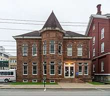
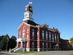 Herkimer County Courthouse | |||
| |||
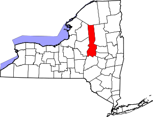 Location in the U.S. state of New York | |||
 New York's location in the U.S. | |||
| Founded | 1791 | ||
| Named for | Nicholas Herkimer | ||
| Seat | Herkimer | ||
| Largest town | German Flatts | ||
| Area | |||
| • Total | 1,458 sq mi (3,776 km2) | ||
| • Land | 1,411 sq mi (3,654 km2) | ||
| • Water | 46 sq mi (119 km2), 3.2% | ||
| Population | |||
| • (2010) | 64,519 | ||
| • Density | 46/sq mi (18/km2) | ||
| Congressional districts | 21st, 22nd | ||
| Time zone | Eastern: UTC−5/−4 | ||
| Website |
www | ||


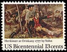
Herkimer County is a county in the U.S. state of New York. As of the 2010 census, the population was 64,519.[1] Its county seat is Herkimer.[2] The county was created in 1791 north of the Mohawk River out of part of Montgomery County. It is named after General Nicholas Herkimer,[3] who died from battle wounds in 1777 after taking part in the Battle of Oriskany during the Revolutionary War.
Herkimer County is part of the Utica–Rome Metropolitan Statistical Area.
History
In 1791, Herkimer County was created as one of three counties split off from Montgomery (the other two being Otsego and Tioga counties) as New York State was developed after the American Revolutionary War. Its area was much larger than the present county, however, and was reduced subsequently as more counties were organized.
Part of Herkimer County was included in the Macomb's Purchase of 1791, during the wide-scale sale of public lands after the state forced Iroquois tribes allied with the British during the war to cede their territory. Suddenly the state was selling 5 million acres (20,000 km2) of land in upstate, central and western New York.
In 1794, Onondaga County was split off from Herkimer County. This county was larger than the current Onondaga County, and included the present Cayuga, Cortland, and part of Oswego counties.
In 1798, portions of Herkimer and Tioga counties were taken to form Chenango County.
Another part of Herkimer was split off to form Oneida County. It was then larger than the current Oneida County, including the present Jefferson, Lewis, and part of Oswego counties.
In 1802, parts of Herkimer, Clinton and Montgomery counties were combined to form the new St. Lawrence County.
The rural economy was first based on general agriculture and then wheat, but after the opening of the Erie Canal, Herkimer farmers found that they could not compete with grain farmers to the west. By the mid-19th century, they had begun to specialize in dairy farming and created a cheese industry that supplied the New York City market, among others.
By the late 20th and early 21st centuries, some small farmers had begun to revive an artisan cheese industry and sustainable dairy farming here and in other parts of the central state. In 2008 New York had the third-largest milk production in the nation and was fourth-ranking in production of cheese, according to Cornell University. It has several inter-disciplinary programs related to the dairy industry.[4]
During the American Civil War, Herkimer contributed five companies to the 34th New York Volunteer Infantry Regiment, leading to the unit's nickname "The Herkimer Regiment".
Geography
According to the U.S. Census Bureau, the county has a total area of 1,458 square miles (3,780 km2), of which 1,411 square miles (3,650 km2) is land and 46 square miles (120 km2) (3.2%) is water.[5]
Herkimer County is in central New York State, northwest of Albany, and east of Syracuse. The northern part of the county is in the Adirondack Park. The Mohawk River flows across the south part of the county.
Demographics
| Historical population | |||
|---|---|---|---|
| Census | Pop. | %± | |
| 1800 | 14,479 | — | |
| 1810 | 22,046 | 52.3% | |
| 1820 | 31,017 | 40.7% | |
| 1830 | 35,870 | 15.6% | |
| 1840 | 37,477 | 4.5% | |
| 1850 | 38,244 | 2.0% | |
| 1860 | 40,561 | 6.1% | |
| 1870 | 39,929 | −1.6% | |
| 1880 | 42,669 | 6.9% | |
| 1890 | 45,608 | 6.9% | |
| 1900 | 51,049 | 11.9% | |
| 1910 | 56,356 | 10.4% | |
| 1920 | 64,962 | 15.3% | |
| 1930 | 64,006 | −1.5% | |
| 1940 | 59,527 | −7.0% | |
| 1950 | 61,407 | 3.2% | |
| 1960 | 66,370 | 8.1% | |
| 1970 | 67,633 | 1.9% | |
| 1980 | 66,714 | −1.4% | |
| 1990 | 65,797 | −1.4% | |
| 2000 | 64,427 | −2.1% | |
| 2010 | 64,519 | 0.1% | |
| Est. 2016 | 62,613 | [6] | −3.0% |
| U.S. Decennial Census[7] 1790-1960[8] 1900-1990[9] 1990-2000[10] 2010-2013[1] | |||
As of the census[11] of 2000, there were 64,427 people, 25,734 households, and 17,113 families residing in the county. The population density was 46 people per square mile (18/km²). There were 32,026 housing units at an average density of 23 per square mile (9/km²). The racial makeup of the county was 97.83% White, 0.51% Black or African American, 0.22% Native American, 0.41% Asian, 0.02% Pacific Islander, 0.18% from other races, and 0.84% from two or more races. 0.90% of the population were Hispanic or Latino of any race. 20.6% were of Italian, 16.3% German, 13.9% Irish, 9.3% English, 7.7% Polish, 6.2% American and 5.2% French ancestry according to Census 2000. 95.2% spoke English, 1.2% Spanish and 1.1% Italian as their first language.
There were 25,734 households out of which 30.60% had children under the age of 18 living with them, 51.20% were married couples living together, 10.30% had a female householder with no husband present, and 33.50% were non-families. 27.60% of all households were made up of individuals and 13.70% had someone living alone who was 65 years of age or older. The average household size was 2.46 and the average family size was 2.99.
In the county, the population was spread out with 24.40% under the age of 18, 8.30% from 18 to 24, 26.60% from 25 to 44, 24.00% from 45 to 64, and 16.80% who were 65 years of age or older. The median age was 39 years. For every 100 females there were 94.20 males. For every 100 females age 18 and over, there were 91.70 males.
The median income for a household in the county was $32,924, and the median income for a family was $40,570. Males had a median income of $29,908 versus $21,518 for females. The per capita income for the county was $16,141. About 8.90% of families and 12.50% of the population were below the poverty line, including 15.60% of those under age 18 and 10.40% of those age 65 or over.
Government and politics
| Year | Republican | Democratic | Third Parties |
|---|---|---|---|
| 2016 | 63.6% 16,699 | 30.8% 8,083 | 5.6% 1,473 |
| 2012 | 53.0% 13,282 | 45.0% 11,273 | 1.9% 485 |
| 2008 | 53.8% 14,619 | 44.5% 12,094 | 1.7% 471 |
| 2004 | 56.6% 16,024 | 41.2% 11,675 | 2.2% 611 |
| 2000 | 51.1% 14,147 | 44.1% 12,224 | 4.8% 1,334 |
| 1996 | 37.9% 10,085 | 44.7% 11,910 | 17.4% 4,631 |
| 1992 | 40.3% 12,052 | 36.3% 10,880 | 23.4% 7,007 |
| 1988 | 53.9% 15,104 | 45.3% 12,694 | 0.8% 224 |
| 1984 | 64.4% 18,827 | 35.4% 10,346 | 0.3% 85 |
| 1980 | 50.6% 14,105 | 41.2% 11,497 | 8.2% 2,286 |
| 1976 | 54.1% 15,362 | 45.4% 12,875 | 0.5% 140 |
| 1972 | 67.8% 20,194 | 31.9% 9,487 | 0.3% 86 |
| 1968 | 54.9% 15,192 | 39.5% 10,940 | 5.5% 1,533 |
| 1964 | 33.5% 10,159 | 66.4% 20,136 | 0.1% 22 |
| 1960 | 54.2% 17,758 | 45.7% 14,977 | 0.1% 33 |
| 1956 | 71.7% 22,246 | 28.3% 8,789 | 0.0% 0 |
| 1952 | 64.3% 20,980 | 35.5% 11,599 | 0.2% 70 |
| 1948 | 51.8% 14,688 | 44.4% 12,577 | 3.8% 1,073 |
| 1944 | 55.8% 15,656 | 44.1% 12,381 | 0.2% 48 |
| 1940 | 57.4% 17,590 | 42.5% 13,013 | 0.2% 54 |
| 1936 | 54.7% 15,941 | 44.1% 12,847 | 1.2% 341 |
| 1932 | 56.6% 15,158 | 41.8% 11,194 | 1.6% 438 |
| 1928 | 62.7% 18,624 | 35.9% 10,654 | 1.5% 431 |
| 1924 | 66.3% 15,625 | 27.4% 6,464 | 6.3% 1,474 |
| 1920 | 65.3% 14,310 | 29.7% 6,507 | 5.1% 1,107 |
| 1916 | 54.4% 7,934 | 43.0% 6,271 | 2.6% 375 |
| 1912 | 34.4% 4,665 | 37.7% 5,122 | 27.9% 3,793 |
| 1908 | 55.9% 8,202 | 40.3% 5,918 | 3.8% 559 |
| 1904 | 56.8% 8,319 | 39.8% 5,827 | 3.4% 499 |
| 1900 | 57.8% 8,100 | 38.5% 5,401 | 3.7% 521 |
| 1896 | 59.8% 8,096 | 37.1% 5,027 | 3.1% 422 |
| 1892 | 49.9% 6,219 | 44.4% 5,526 | 5.7% 709 |
| 1888 | 52.9% 6,683 | 44.4% 5,611 | 2.7% 346 |
| 1884 | 51.8% 6,138 | 45.0% 5,329 | 3.2% 384 |
The Herkimer County Legislature consists of 17 members, each elected from single-member districts.
Herkimer County is one of the most politically conservative counties in New York. In 2010, it was one of the few counties outside of Western New York to vote for Carl Paladino over Andrew Cuomo in the gubernatorial election.
The county is currently located in the New York's 21st congressional district and is represented by Republican Elise Stefanik. She was elected in the 2014 Midterm elections by a high margin of 21.7%. Then 30, she was the youngest woman in United States history to be elected to the House of Representatives. It is also located in New York's 22nd Congressional District and is currently Represented by Republican Claudia Tenney.
Economy
Herkimer County is known for producing unusual clear, doubly terminated quartz crystals, marketed as Herkimer diamonds.
Ilion in Herkimer County has one of two production sites of the Remington Arms Company, where many of the company's firearms are produced.
Education
Herkimer County Community College is located in the Village of Herkimer.
Transportation
Airport
The following public use airport is located in the county:[13]
- Frankfort-Highland Airport (6B4) – Frankfort
Communities
City
Towns
Villages
- Cold Brook
- Dolgeville
- Frankfort
- Herkimer (county seat)
- Ilion
- Middleville
- Mohawk
- Newport
- Poland
- West Winfield
Census-designated places
Hamlets
See also
References
- 1 2 "State & County QuickFacts". United States Census Bureau. Archived from the original on July 11, 2011. Retrieved October 11, 2013.
- ↑ "Find a County". National Association of Counties. Archived from the original on 2011-05-31. Retrieved 2011-06-07.
- ↑ Gannett, Henry (1905). The Origin of Certain Place Names in the United States. Govt. Print. Off. p. 155.
- ↑ Thomas R. Overton, "The New York Dairy Industry and Cornell" Archived 2016-10-11 at the Wayback Machine., CCE Tompkins
- ↑ "2010 Census Gazetteer Files". United States Census Bureau. August 22, 2012. Archived from the original on May 19, 2014. Retrieved January 5, 2015.
- ↑ "Population and Housing Unit Estimates". Archived from the original on May 29, 2017. Retrieved June 9, 2017.
- ↑ "U.S. Decennial Census". United States Census Bureau. Archived from the original on May 12, 2015. Retrieved January 5, 2015.
- ↑ "Historical Census Browser". University of Virginia Library. Archived from the original on August 16, 2012. Retrieved January 5, 2015.
- ↑ "Population of Counties by Decennial Census: 1900 to 1990". United States Census Bureau. Archived from the original on February 19, 2015. Retrieved January 5, 2015.
- ↑ "Census 2000 PHC-T-4. Ranking Tables for Counties: 1990 and 2000" (PDF). United States Census Bureau. Archived (PDF) from the original on December 18, 2014. Retrieved January 5, 2015.
- ↑ "American FactFinder". United States Census Bureau. Archived from the original on 2013-09-11. Retrieved 2008-01-31.
- ↑ Leip, David. "Dave Leip's Atlas of U.S. Presidential Elections". uselectionatlas.org. Archived from the original on 23 March 2018. Retrieved 7 May 2018.
- ↑ Herkimer County Public and Private Airports, New York Archived 2011-10-19 at the Wayback Machine.. Retrieved June 13, 2013.
Further reading
- Benton, Nathaniel Soley (1856). A History of Herkimer County, Including the Upper Mohawk Valley, from the Earliest Period to the Present Time. Albany, New York: J. Munsell. OCLC 11081494.
External links
| Wikimedia Commons has media related to Herkimer County, New York. |
- Herkimer County official website
- President Benjamin Harrison's Summer home
- Herkimer County at Curlie (based on DMOZ)
- Early history summary of Herkimer County
- Herkimer County history pages
- Herkimer County Historical Society website
Places adjacent to Herkimer County, New York | ||||||||||
|---|---|---|---|---|---|---|---|---|---|---|
| ||||||||||
Municipalities and communities of Herkimer County, New York, United States | ||
|---|---|---|
| City | | |
| Towns | ||
| Villages | ||
| CDPs | ||
| Other hamlets |
| |
| Footnotes | ‡This populated place also has portions in an adjacent county or counties | |