Mirzapur
| Mirzapur Vindhyanagar | |
|---|---|
| City | |
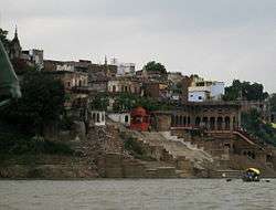 Bariya Ghat | |
 Mirzapur  Mirzapur | |
| Coordinates: 25°08′46″N 82°34′08″E / 25.146°N 82.569°ECoordinates: 25°08′46″N 82°34′08″E / 25.146°N 82.569°E | |
| Country |
|
| State | Uttar Pradesh |
| Government | |
| • District Magistrate | Anurag Patel (IAS) |
| • Member of Lok Sabha | Anupriya Singh Patel (Apna Dal) |
| Elevation | 80 m (260 ft) |
| Population (2011)[1] | |
| • City | 233,691 |
| • Density | 567/km2 (1,470/sq mi) |
| • Metro[2] | 245,817 |
| Languages | |
| • Official | Hindi, Urdu |
| Time zone | UTC+5:30 (IST) |
| PIN | 231001 |
| Telephone code | 05442 |
| Vehicle registration | UP-63 |
| Sex ratio | 0.903 (2011) |
| Literacy | 68.48% (2011) (78.97%♂; 56.86%♀) |
| Website |
www |
Mirzapur ![]()
History
Before the establishment of the town, the area was a dense forest and freely used by various states like Varanasi (A.K.A.:-Benaras), Sakteshgarh, Vijaygarh, Nainagarh (Chunar), Naugarh, Kantit and Rewa for Hunting. British East India Company had established this area to fulfill the needs of a trading center between central and western India. This time Rewa was a well-established state of central India and was directly connected with Mirzapur by the Great Deccan Road. Over the time Mirzapur became a famous trading center of Central India and started trading of cotton, and silk at very large scale.
The East India Company named this place as Mirzapore (मिर्ज़ापुर). The word Mirzapur is derived from 'Mirza' which in turn is derived from the Persian term ‘Trip Kalchu which literally means "child of the ‘Amīr" or "child of the ruler". In Persia‘ Amīrzād in turn consists of the Arabic title ‘Amīr (English. "Emir"), meaning "commander", and the Persian suffix -zād, meaning "birth" or "lineage". Due to vowel harmony in Turkic languages, the alternative pronunciation Morza (plural morzalar; derived from the Persian word) is also used. The word entered English in 1595, from the French émir. The meaning of Mirzapur is the place of King.
Most of the city was established by British officers, but the starting development was founded by the most famous officer of British East India Company "Lord Marquess Wellesley". As per some evidence the British construction was initiated from Burrier (Bariya) Ghat. Lord Wellesley has reconstructed the Burrier Ghat as a main entrance in Mirzapur by Ganga. Some of the places in Mirzapur was pronounced as per the name of Lord Wellesley, like Wellesleyganj (The first market in Mirzapur), Mukeri Bazar, tulsi chowk etc. The building of Municipal Corporation is also a precious example of British Constructions.
It is the place in India where the Holy River Ganges meets with Vindhya Range. This is considered significant in Hindu Mythology and has a mention in Vedas. Near mirzapur founded a religious place vindhyanchal. Vindhyachal, a Shakti Peeth, is a centre of pilgrimage in Mirzapur District, Uttar Pradesh. The Vindhyavasini Devi temple located here is a major draw and is thronged by thousands of devotees during the Navratris of Chaitra and Ashwin months to invoke the blessings of the Goddess. Other sacred places in the town are Ashtbhuja temple, Sita Kund, Kali Khoh, Budeh Nath temple, Narad Ghat, Gerua talab, Motiya talab, Lal Bhairav and Kal Bhairav temples, Ekdant Ganesh, Sapta Sarovar, Sakshi Gopal temple, Goraksha-kund, Matsyendra kund, Tarkeshwar Nath temple,'Narghat Kali Ji Mandir,Kankali Devi temple, Shivashiv Samooh Awadhoot Ashram, Badeura nath temple and Bhairav kund. Mirzapur is the closest railhead. Vindhyachal has regular bus services to the nearby towns. The nearest railway station is at Mirzapur. Regular bus services connect Vindhyachal to the nearby towns.

A step towards the awareness for voting the District of Mirzapur came with the Guinness World Record for the biggest Rangoli (Alpana) created in an area of 39,125 m2 using approx 120,000 kg of color by across 3500 students and teachers from 50 schools on occasion of National Voters Day (Hindi: राष्ट्रीय मतदाता दिवस).[6] This city is situated at bank of river Ganga.
Geography
Mirzapur is located at 25°09′N 82°35′E / 25.15°N 82.58°E.[7] It has an average elevation of 80 metres (265 feet). The District of Mirzapur lies between the parallels of 23.52 & 25.32 North latitude and 82.7 and 83.33 East longitude. It forms a portion of the Varanasi district. On the north and north-east it is bounded by the Varanasi district; on the south bounded by Sonbhadra district; on the north-west by Allahabad district. The shape to the north and west is totally regular. In no direction, except for about 13 km. in the north-east where the Ganges separates the Tehsil of Chunar from the district of Varanasi, has Mirzapur a natural frontier. The Chanvar fields, considered to be one of the most fertile lands tracts in India, are located on Gangetic flood plains of the district. Also, Indian Standard Time is calculated on the basis of 82.5° E longitude, from a clock tower in Mirzapur
According to Central Statistical organisation the district of Mirzapur had an area of 4521 km2. In 2011, Mirzapur had population of 2,496,970 of which male and female were 1,312,302 and 1,184,668 respectively. In 2001 census, Mirzapur had a population of 2,116,042 of which males were 1,115,249 and remaining 1,000,793 were females.[8]
Some geographical locations around Mirzapur district is depicted below
Places adjacent to Mirzapur | |
|---|---|
Demographics
As of the 2011 census, Mirzapur-cum-Vindhyachal municipality had a population of 233,691[1] and the urban agglomeration had a population of 245,817.[2] The municipality had a sex ratio of 869 females per 1,000 males and 11.9% of the population were under six years old.[1] Effective literacy was 78.25%; male literacy was 83.85% and female literacy was 71.80%.[1]
Commerce
The main business in Mirzapur is carpet manufacturing. Manufacturers range from very small (with less than $100,000 in assets) to medium-sized (with around $10M in assets). Most of the carpets are sold internationally as India has a limited market for carpets. The second main business is of metal pots(brass).
Indian Standard Time calculation
Indian Standard Time is calculated from the clock tower in Mirzapur nearly exactly on the reference longitude of Indian Standard Time at 82.5°, within 4 angular minutes, a property shared by Tuni, a town in Andhra Pradesh.[9]
Tourism
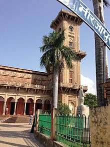
For quite some years Mirzapur has been a destination for tourists, particularly for people from adjoining states, owing mainly to the ghats, temples, the famous clock tower(Ghanta Ghar)which are excellent examples of contemporary architecture. [10] [11]
Temples and mosques
- Vindhyachal
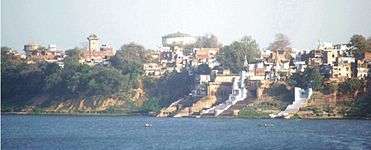
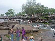
A few miles away from the city is a site of a pilgrimage for Hindus known as Vindhyachal where according to the mythology a part of Sati (an Avatar of Durga) fell. The river Ganges flows through this city. Other sites of pilgrimage include Kali Khoh (literally 'the cave of the Goddess Kali') where a statue of the Kali has a mouth formed in the shape of a cave, hence the name. Very close to the city is a waterfall. The city itself has many Ghats (steps to a river).
- Ghanta Ghar (Clock Tower)
The famous Ghanta Ghar of Mirzapur is located in the premises of city corporation, about 3 km from the Mirzapur Railway Station. Currently not functioning, it was constructed in the year 1891, with its entire structure made up of finely carved stone and a 1000 kg alloy bell hanging from the tall structure.
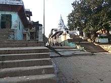
Ghats
Ojhala Bridge
The Ojhala Bridge was constructed by Mahant Parshuram Giri in Vikram Samvat 1772. This valuable heritage connecting the cities of Mirzapur and Vindhyachal, with fort like minarets and ramparts on the either side of the bridge, provide a fine instance of contemporary architecture.
Culture
- Festivals of the city: jeevitputrika (jutiya), Ganges Deshahara, lalahi chattha, shardiya and vasantik navratra, ojhala ka mela (a fair at the Ojhla Bridge), lohandi ka mela (fair), the famous Vindhya Mahotsava, horaha gaderi ka mela, litti bati ka mela, and maa bhandari ka mela (various fairs at different places on different occasions).
- Kajari Mahotsava: It is among the famous festivals of Mirzapur. Respected all over India, kajali took birth here. King Kantit 9Naresh's daughter Kajali loved her husband very much and sang songs in the moment of separation from her husband, although she could not meet her husband throughout her life and died, yet she remains alive through these deep sad-love songs. Her voice and songs impress Mirzapur locals very much, so they remember her through this festival paying homage to her.
- Lohandi Mela: 2 km south of Mirzapur an old temple of Lord Hanuman is decorated with light (ghee ke deeye) on kartik purnima and every Saturday in the month of Saawan (Hindu month of rain in the middle of July–August), a big fair is arranged. The attraction is tattoo design.
- Ojhala Mela: Ojhala is the current name of the Ujjvala River. A fair used to be arranged regularly here since 1920, which is a sign of bravery and the only place in India where betting is legal on the days of the fair. This has been discontinued since there is not enough water at the bridge for the various water sports that used to take place.
- Vindhyavasini Jayanti Samaaroh: Started in 1971, this musical program is arranged by the Government where renowned Indian vocal and folk artists give real presentations and worship the goddess Vindhyavasini.
- Deep Mahotsava: Celebrated on the day of Diwali, all the Ganges ghats are decorated with lights, locals have immense pleasure celebrating this on kartik amavasya.
- Jhoolanotsava: In the month of Saawan celebrated by locals during rain, this Jhoolanotsava is celebrated with swings in the branches of trees for four days. Shree Dwarkadheesh Temple, Ganga Jamuna Saraswati Temple and Kunj Bhawan are decorated at the Rakshabandhan festival.
- Nagpanchami Mela :It is organised at the night of nagpanchami in Ganesh ganj near Mukeri bazar where all the temples being decorated and several shops of food and culture are open that day where thousands of people visit.
- ShivShankari Dham Mela :It is organised at the time of holy Navratras in Chaitra(March/April) every year in ShivShankari Dham premises for three days and devotees do devi darshan and enjoy the fair events mainly death of well(performed under supervision) circus, magic, jhoolas,dance programs.Many temporary shops also covers the premises of Dham for tourists and local villagers of Chunar-Marihan Region of Mirzapur and it is situated in extreme north,50 Km from the district headquarters i.e. on NH-7 and Mirzapur-Varanasi Road between Kailhat-Ahraura Road Railway Station and nearby markets are Parsodha(Purushottampur),Kailhat,Narayanpur.
- BhandariDevi Mela & Bechubeer Mela :It is organised by the local villagers and famous fair in Ahraura area of Marihan constituency of Mirzapur located in northeast of district. Maa Bhandari Devi is very famous temple on the hills of Ahraura with Natural parks to enjoy the hill view along with Devi Darshan and Satua Puja.From Varanasi 30 Km on SH-5A via Ramnagar Bypass(Tengra Modh)- Narayanpur-Adalhat-Ahraura.
Education
Being a vast emerging centre of tradition, culture & civilisation[12] the city which get blessed by Holy river Ganges accept itself as the need of time to deliver the adequate quality education. The youth of the city trend themselves as per the demand of modern era. The district itself is the centre of more than 75 colleges[13] for the youth having more than 20,200 enrolments per year reported by the Department of Higher Education Ministry of Human Resource Development survey for higher education in 2014.Due to connective with two major cities of Uttar Pradesh i.e. Varanasi & Allahabad the city itself get blessed by Maa Vindhyavasini along with Kashi Vishwanath.
The relation of education with Kashi and establishment of Banaras Hindu University start in 1878 when Pt. Mahamana Madan Mohan Malviya accept the daughter of city Sri Kundan Devi as Life partner.[14] After well establishment of BHU in Varanasi, Mirzapur benefitted as University known as Rajiv Gandhi South Campus at Barkachha[15] acquired by BHU, on lease in perpetuity from Bharat Mandal Trust[16] in April 1979 with an area of 1104 hectare situated about 8 km South West of Mirzapur City. At present RGSC (Rajiv Gandhi South Campus) is spread over 2700 acres and has been used to run special courses of Banaras Hindu University. This campus is situated in the lap of nature and gives a feeling of Gurukul in this modern era. Very soon a Veterinary college will also open as a part of RGSC, BHU. Institutes
- Govt Engineering College Mirzapur
- RGSC BHU Barkachha Mirzapur
- K.B. Postgraduate College, Mirzapur [17]
- G.D.Binani P.G. College Mirzapur
- Rajkiya Mahavidyalaya, Adalhat, Mirzapur
- Kamala Maheshwari Arya Kanya Snatkottar Mahavidyalaya, Mirzapur
- Banasthali Mahavidyalaya, Ahraura, Mirzapur
- Rajkiya Mahavidyalaya, Chunar, Mirzapur.
Some schools in Mirzapur are:
S.N.Public School, KIC Public School
Daffodils Public School, Lion's School LalDiggi Mirzapur, Sunbeam Schools Mirzapur.
Chunar
Main Article:- Chunar
The Chunar Fort was established by Maharaja Vikramaditya, the King of Ujjain, in honour of the stay of his brother Raja Bharthari. About 32 km from Mirzapur is the famous fortress of Chunar. The Chunar Fort is situated on an extension of the Vindhyan range of mountains, with the river Ganges flowing near its base. Various exotic waterfalls and religious worship places attract thousands of tourists and locals.
There are some rock paintings in Mirzapur district. Chunar tehsil is famous for its pottery and clay industries,many sculptures are living their livelihoods by making Durga Puja Statues for Durga Pooja in Various regions of Chunar. Chunar is having cement,iron,cutting stone industries. In July 2018 Mirzapur's only Passport Office is established at the Post Office Chunar for district people to travel abroad hassle free. Chunar Ganga Bridge started for people to reach easily Varanasi City. Purvanchal Vidyut Vitaran Nigam Ltd.(UPPCL)is located at Pirallipur village of Chunar as a Power House Distribution Centre. In Chunar Tehsil Narayanpur block is famous for Bricks Manufacturing area due to best suitable soil quality especially ShivShankariDham,Purushottampur,Bhopati,Sahaspura,Fattepur,Ramjipur,Parsiya,Rupaudha,Belwari,Bangla-Devariya,Barewan,Kailhat,Narayanpur.
Kachhwa bazaar
Main article:- Kachhwa.
Kachhwa is a town and a nagar panchayat in Mirzapur district, located at 25.22°N 82.72°E. It has an average elevation of 84 metres (275 feet). It is around 35 km from Varanasi Cantt. This place is known for Kachhwa Christian hospital which is a 20-bed hospital, set by Christian missionary Dr. Neville Everad to provide medical care to the nearby town.
Kachhwa is one of biggest markets in Mirzapur.
References
- 1 2 3 4 "Provisional Population Totals, Census of India 2011; Cities having population 1 lakh and above" (PDF). Office of the Registrar General & Census Commissioner, India. Retrieved 26 March 2012.
- 1 2 "Provisional Population Totals, Census of India 2011; Urban Agglomerations/Cities having population 1 lakh and above" (PDF). Office of the Registrar General & Census Commissioner, India. Retrieved 26 March 2012.
- ↑ "Google Maps". Google Maps. Retrieved 2017-05-23.
- ↑ "Google Maps". Google Maps. Retrieved 2017-05-23.
- ↑ "Mirzapur District Population Census 2011, Uttar Pradesh literacy sex ratio and density". www.census2011.co.in. Retrieved 2017-05-23.
- ↑ TOI, Mirzapur Created a History by spread Awareness (Jan 26, 2017). "Times of India" – via http://timesofindia.indiatimes.com/.
- ↑ Falling Rain Genomics, Inc – Mirzapur. Fallingrain.com. Retrieved on 1 June 2012.
- ↑ "Mirzapur District Population Census 2011, Uttar Pradesh literacy sex ratio and density". www.census2011.co.in. Retrieved 2017-05-23.
- ↑ India investigates different time zones. BBC. 21 August 2001
- ↑ added on 23 June 2013
- ↑ added on 23 June 2013
- ↑ "KAJARI".
- ↑ "Ministry of Human Resource 2014" (PDF).
- ↑ "RGSC About Campus". www.bhu.ac.in. Retrieved 15 April 2016.
- ↑ "Rajiv Gandhi South Campus".
- ↑ "BHU South Campus".
- ↑ http://www.kbpgcollege.org/
External links
| Wikivoyage has a travel guide for Mirzapur. |
| Wikimedia Commons has media related to Mirzapur. |