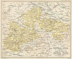
Central India Agency
| Central India Agency | |||||
| Agency of British India | |||||
| |||||
 | |||||
| History | |||||
| • | Merger of previous political offices | 1854 | |||
| • | Independence of India | 1947 | |||
| Area | |||||
| • | 1881 | 194,000 km2 (74,904 sq mi) | |||
| Population | |||||
| • | 1881 | 9,261,907 | |||
| Density | 47.7 /km2 (123.7 /sq mi) | ||||
The Central India Agency was created in 1854, by amalgamating the Western Malwa Agency with other smaller political offices which formerly reported to the Governor-General of India. The agency was overseen by a political agent who maintained British relations with the princely states and influence over them on behalf of the Governor-General. The headquarters of the agent were at Indore.
History
British hegemony over the states of Central India began in 1802, when several states in the Bundelkhand and Bagelkhand regions came under British control at the conclusion of the Treaty of Bassein between the British and the Maratha - Peshwa Bajirao II. British control of Bundelkhand expanded at the conclusion of the Second Anglo-Maratha War in 1805. The remaining states, including Gwalior, Indore, Bhopal and a number of smaller states in the regions of Malwa, Nimar, and Bundelkhand, came under British control with the end of the Third Anglo-Maratha War in 1818. The estate of Chanderi was ceded to the Sindhia ruler of Gwalior in 1844 by the British, and Jhansi State was seized by the British in 1853 under the doctrine of lapse was added to the United Provinces. In 1921 Gwalior Residency was separated from the Central India Agency, and in 1933 the state of Makrai transferred to Central India from the Central Provinces and Berar.
Princely States
The princely states in the area of the Agency, 148 in all, varied in status and greatly in size.
- Eleven states held treaty relations directly with the British Government, and were known as the treaty states: Gwalior State, Indore State, Bhopal State, Dhar State, the two Dewas States, Jaora, Orchha, Datia, Samthar and Rewa.
- The 31 sanad states had direct relations with the British Government, but not by treaty. These states, in Bundelkhand and Bagelkhand, were granted deeds (sanads) confirming rulers in possession of their states, in return for the rulers signing a written bond of allegiance (ikrarnama) to the British.
- The remaining smaller states and estates were known as mediatized or guaranteed states.
- Mediatized states were under the authority of a larger state, with the relationship between the states arranged through British mediation.
- Guaranteed states, found only in Malwa, were states under the authority of larger states, in which the British guaranteed whatever rights existed at the time of British occupation of the region at the conclusion of the Pindari War.
The princely states were closely related to one of several political officers, which were rearranged a number of times in the history of the Agency. Upon the British withdrawal from India in 1947, the political offices consisted of Indore Residency and the Bundelkhand, Bhopal and Malwa Agencies.
Bundelkhand Agency
Bundelkhand Agency was bounded by Bagelkhand to the east, the United Provinces to the north, Lalitpur District to the west, and the Central Provinces to the south. Bagelkhand Agency was separated from Bundelkhand in 1871. In 1900 it included 9 states, the most important of which were Orchha, Panna, Samthar, Charkhari, Chhatarpur, Datia, Bijawar and Ajaigarh. The agency also included 13 estates and the pargana of Alampur, the latter belonging to Indore State.[1]
In 1931, all of the states under the Baghelkhand Agency apart from Rewa were transferred back to Bundelkhand.
Salute states, by precedence :
- Datia, title Maharaja, Hereditary salute of 15-guns
- Orchha,[2] title (Maha)raja (from 1882, Saramad-i-Rajha-i-Bundelkhand Maharaja), Hereditary salute of 15-guns
- Ajaigarh, title Maharaja, Hereditary salute of 11-guns
- Baoni, title Nawab, Hereditary salute of 11-guns
- Bijawar, title Maharaja, Hereditary salute of 11-guns
- Charkhari, title Maharaja, Hereditary salute of 11-guns
- Panna, title Maharaja, Hereditary salute of 11-guns
- Samthar, title Raja, Hereditary salute of 11-guns
Non-salute states, alphabetically :
- Alipura, title Rao
- Beri (Beri-Bundelkhand) , title Rao/Raja (originally Dewan)
- Bihat
- Chhatarpur, title (Maha)Raja
- Garrauli
- Gaurihar, title Sardar Sawai; from 1859, Rao
- Jigni, title Rao
- Lugasi
- Naigawan Rebai
- Sarila, title Raja
Jagirs :
- Banka-Pahari
- Bijna
- Bilheri jagir, ?under Chhatarpur, guaranteed by the British
- Dhurwai
- Tori Fatehpur (one of the Hasht-Bhaiya jagirs)
Former princely States that were annexed or seized by the British :
- Banpur, seized in 1857, had been claimed by Gwalior State
- Bijeraghogarh, seized
- Chirgaon (one of the Hasht Bhaiya jagirs), seized
- Jalaun, annexed in 1840
- Jaitpur, annexed in 1849
- Jhansi, annexed in 1853
- Khaddi, annexed
- Purwa (one of the Chaube Jagirs), seized
- Tiroha, seized
- Shahgarh, seized in 1857
Bagelkhand Agency
Bagelkhand Agency, the easternmost charge, was established in March 1871, when it was separated from Bundelkhand agency. In 1900, it covered the area of twelve states, including :
Salute states, by precedence :
- Rewa, the largest state in Bagelkhand, title Maharaja, Hereditary salute of 17-guns
- Baraundha, title Raja, Hereditary salute of 9-guns
- Maihar, title Raja, Hereditary salute of 9-guns
Non-salute states (alphabetically) :
In 1931, all of the states but Rewa were transferred back to Bundelkhand, and in 1933 Rewa was transferred to the Indore Residency.
Gwalior Residency
Gwalior Residency was placed under the Central India Agency in 1854, and separated from Central India Agency in 1921. It included the following, among other smaller states, plus Chhabra pargana (district) of Tonk State :
Salute states :
- Gwalior, title Maharaja Scindia; Hereditary salute of 21-guns
- Rampur, title Nawab; Hereditary salute of 15-guns
- Benares (Ramnagar), title Maharaja; Hereditary salute of 13-guns (15-guns local)
Non-salute states :
- Bhadaura
- Garha
- Khaniadhana
- Raghogarh
- Paron
- Umri
Furthermore, lesser estates (under Thakurs or diwans)
- Agra Barkhera
- Kathaun
- Khiaoda
- Sangul Wardha
- Sirsi
Bhopal Agency
Bhopal Agency, 11,653 sq mi (30,180 km2), which included the following :
Salute states, by precedence :
- Bhopal, title Nawab, Hereditary salute of 19-guns (21-guns local)
- Dewas Junior & Dewas Senior, both title Mharaja, Hereditary salutes of 15-guns (transferred to Malwa Agency in 1907, and to Bhopal Agency in 1933)
- Narsinghgarh, title Raja, Hereditary salute of 11-guns
- Rajgarh, title Raja, Hereditary salute of 11-guns
- Khilchipur, title Raja, Hereditary salute of 9-guns
Non-salute states, alphabetically :
- Basoda
- Kurwai (Korwai)
- Makrai (transferred to Bhopal Agency in 1933 from the Central Provinces and Berar)
- Maksudangarh
- Muhammadgarh
- Pathari
Indore Residency
Indore Residency included most of Indore (Holkar) and after 1933 also Rewa State.
Malwa Agency
Malwa Agency, 8,919 sq mi (23,100 km2), which included parts of Gwalior, Indore and Tonk states and the states of:
Salute states, by precedence :
- Jaora State, title Nawab, Hereditary salute of 13-guns
- Ratlam State, title Maharaja, Hereditary salute of 11-guns (13-guns local)
- Jhabua State, title Raja, Hereditary salute of 11-guns
- Sitamau State, title Raja, Hereditary salute of 11-guns
- Sailana State, title Raja, Hereditary salute of 11-guns
Non-salute states :
Estates :
In 1925, the Malwa Agency was amalgamated with Bhopawar Agency.
Bhopawar Agency
Bhopawar Agency included the princely states of: It also included territories of Gwalior and Indore States. In 1927 the agency was renamed the Southern States Agency, later the Southern States and Malwa Agency, and after 1934 Malwa Agency.
Salute states, by precedence :
- Dhar, title Maharaja, Hereditary salute of 15-guns
- Alirajpur, title Raja, Hereditary salute of 11-guns, including the extinct State of Phulmaal which was incorporated into it earlier as well as Fiefs (Jagirs) of .
- Barwani, title Maharana, Hereditary salute of 11-guns
- Jhabua, title Raja, Hereditary salute of 11-guns
Non-salute states :
- Jobat
- Kathiwara
- Mathwar
- Ratanmal
Discontinued :
- Amjhera, title Raja
Jagirs (incomplete) :
- Bakhatgarh
- Dhotria
- Jamnia
- Kachhi-Baroda
- Kali-Baori
- Multhan
- Nimkhera
- Ondhwa
- Rajgadh
- Sondhwa
Post-independence
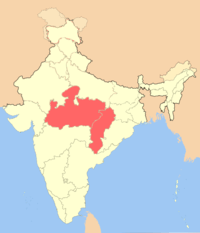
Upon the British withdrawal from India in 1947, the rulers of the princely states in this area all chose to accede to the new Union of India. The eastern portion of Central India Agency, including Bagelkhand and Bundelkhand agencies, became the new state Vindhya Pradesh. The western portion, including Bhopal, Malwa, and Bhopawar agencies and the Gwalior and Indore residencies, became the new state of Madhya Bharat. Bhopal became a separate state. Makrai was transferred to Madhya Pradesh, which had been created from the former Central Provinces and Berar in 1950. In 1956, the states of Vindhya Pradesh, Madhya Bharat, and Bhopal were merged into Madhya Pradesh. Later another state, Chhattisgarh, was formed from the area that was formerly Madhya Pradesh.
See also
References
- ↑ Imperial Gazetteer of India, v. 9, p. 74.
- ↑ Orchha state The Imperial Gazetteer of India, 1909, v. 19, p. 241.
- ↑ About Central India Archived 7 October 2008 at the Wayback Machine., "Attracting pilgrims and tourists from the world over, Madhya Pradesh and Chhattisgarh constitute the geographic heart of India."
- Hunter, William Wilson, Sir, et al. (1908). Imperial Gazetteer of India, Volume 12. 1908-1931; Clarendon Press, Oxford.