Taraon State
| Taraon State | |||||
| Jagir | |||||
| |||||
 | |||||
| History | |||||
| • | Established | 1812 | |||
| • | Independence of India | 1948 | |||
| Area | |||||
| • | 1901 | 67.33 km2 (26 sq mi) | |||
| Population | |||||
| • | 1901 | 3,178 | |||
| Density | 47.2 /km2 (122.2 /sq mi) | ||||
| Today part of | Uttar Pradesh, India | ||||
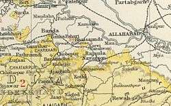
Taraon, also spelt 'Tarahwan' and 'Tarahuhān', was a jagir in India during the British Raj.[1] It had an area of 67 square miles and its population was distributed in 13 villages. The capital of the state was in Pathraundi, located about 1.5 km from Karwi railway station of the Great Indian Peninsula Railway.[2]
Taraon Estate was merged into the Indian state of Vindhya Pradesh in 1948. The area covered by the former state is now in modern Chitrakoot district, at the southern end of Uttar Pradesh.
History
Taraon was founded in 1812 and was located in Taraon Fort, which had been a former possession of the Rajas of Panna State. It was one of the Chaube Jagirs.
It was under the Bundelkhand Agency of the Central India Agency until 1896 when it was transferred to the Baghelkhand Agency. In 1931 Taraon was transferred back to the Bundelkhand Agency.
Rulers
Taraon's rulers bore the title 'Chaube'.
Chaubes
- 1812 - 1840 Gaya Prasad (d. 1840)
- 1840 - 1856 Kamta Prasad (d. 1856)
- 1856 - 1872 Ram Chand (d. 3 March 1872)
- 3 March 1872 – 22 January 1881 Interregnum
- 1881 - 1895 Chhatarbhuj, granted ruling powers on 22 January 1881 (d. 1 January 1895)
- 1895 - 1925 Brij Gopal, declared insane in 1911; the state was administered on his behalf (d. 1925)
- 1925 - 1950 Ganga Prasad (d. 1954)
See also
References
- ↑ "Imperial Gazetteer of India" (GIF). Dsal.uchicago.edu. p. 250. Retrieved 2017-01-25.
- ↑ Great Britain India Office. The Imperial Gazetteer of India. Oxford: Clarendon Press, 1908
Coordinates: 24°59′N 80°57′E / 24.983°N 80.950°E