Sa Bot District
| Sa Bot สระโบสถ์ | |
|---|---|
| Amphoe | |
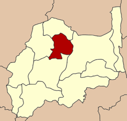 Amphoe location in Lopburi Province | |
| Coordinates: 15°11′43″N 100°50′55″E / 15.19528°N 100.84861°ECoordinates: 15°11′43″N 100°50′55″E / 15.19528°N 100.84861°E | |
| Country | Thailand |
| Province | Lopburi |
| Seat | Niyom Chai |
| Area | |
| • Total | 304.65 km2 (117.63 sq mi) |
| Population (2005) | |
| • Total | 21,279 |
| • Density | 698/km2 (1,810/sq mi) |
| Time zone | UTC+7 (ICT) |
| Postal code | 15240 |
| Geocode | 1608 |
Sa Bot (Thai: สระโบสถ์, pronounced [sàʔ bòːt]) is a district (amphoe) in the northern part of Lopburi Province, central Thailand.
History
The minor district (king amphoe) was created on 5 June 1981, by separating tambons Sa Bot, Maha Phot, and Tha Thung Chang of Khok Samrong District.[1] It was upgraded to a full district on 1 January 1988.[2]
Geography
Neighboring districts are (from the north clockwise) Khok Charoen, Chai Badan, Khok Samrong and Nong Muang.
Administration
The district is divided into five sub-districts (tambon), which are further subdivided into 46 villages (muban). Sa Bot itself has township (thesaban tambon) status and covers all of the tambon Sa Bot. There are three tambon administrative organizations (TAO): Sa Bot, Maha Phot and Niyom Chai.
| No. | Name | Thai name | Villages | Pop. | |
|---|---|---|---|---|---|
| 1. | Sa Bot | สระโบสถ์ | 7,616 | ||
| 2. | Maha Phot | มหาโพธิ | 4,757 | ||
| 3. | Thung Tha Chang | ทุ่งท่าช้าง | 2,029 | ||
| 4. | Huai Yai | ห้วยใหญ่ | 1,553 | ||
| 5. | Niyom Chai | นิยมชัย | 5,324 |
References
- ↑ ประกาศกระทรวงมหาดไทย แบ่งท้องที่อำเภอโคกสำโรง จังหวัดลพบุรี ตั้งเป็นกิ่งอำเภอสระโบสถ์ (PDF). Royal Gazette (in Thai). 98 (90 ง): 1734. June 9, 1981.
- ↑ พระราชกฤษฎีกาตั้งอำเภอนามน อำเภอพระยืน อำเภอหนองบัวระเหว อำเภอบ้านเหลื่อม อำเภอจะแนะ อำเภอหนองหงส์ อำเภอนาโพธิ์ อำเภอเกาะยาว อำเภอแกดำ อำเภอสระโบสถ์ อำเภอโนนคูณ อำเภอควนโดน อำเภอไชยวาน อำเภอหนองแสง และอำเภอตาลสุม พ.ศ. ๒๕๓๐ (PDF). Royal Gazette (in Thai). 104 (278 ก special): 33–37. December 31, 1987.
External links
Lopburi | ||
|---|---|---|
| Main article |  | |
| Capital | ||
| Districts (amphoe) | ||
| Royalty | ||
| Related topics | ||
| Neighboring areas | ||
This article is issued from
Wikipedia.
The text is licensed under Creative Commons - Attribution - Sharealike.
Additional terms may apply for the media files.