Nong Muang District
| Nong Muang หนองม่วง | |
|---|---|
| Amphoe | |
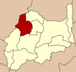 Amphoe location in Lopburi Province | |
| Coordinates: 15°14′50″N 100°39′15″E / 15.24722°N 100.65417°ECoordinates: 15°14′50″N 100°39′15″E / 15.24722°N 100.65417°E | |
| Country | Thailand |
| Province | Lopburi |
| Seat | Nong Muang |
| Area | |
| • Total | 445.5 km2 (172.0 sq mi) |
| Population (2005) | |
| • Total | 35,257 |
| • Density | 79.1/km2 (205/sq mi) |
| Time zone | UTC+7 (ICT) |
| Postal code | 15170 |
| Geocode | 1611 |
Nong Muang (Thai: หนองม่วง, pronounced [nɔ̌ːŋ mûa̯ŋ]) is a district (amphoe) in the northern part of Lopburi Province, central Thailand.
History
Following a suggestion issued in 1989,[1] six tambon were separated from Khok Samrong to form the new minor district (king amphoe) Nong Muang on 1 April 1990.[2] The minor district was upgraded to full district status on 5 December 1996.[3]
Geography
Neighboring districts are (from the northeast clockwise) Khok Charoen, Sa Bot, Khok Samrong, Ban Mi, and the districts Takhli, Tak Fa and Phaisali of Nakhon Sawan Province.
Administration
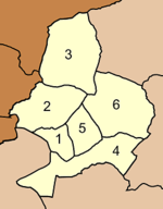
The district is divided into six sub-districts (tambon), which are further subdivided into 67 villages (muban). Nong Muang itself has township (thesaban tambon) status and covers part of the tambon Nong Muang. There are six tambon administrative organizations (TAO).
|
 |
References
- ↑ กระทู้ถามที่ ๑๒๗ ร. เรื่อง ขอให้ตั้งกิ่งอำเภอหนองม่วง จังหวัดลพบุรี (PDF). Royal Gazette (in Thai). 106 (148 ง): 6479. September 7, 1989.
- ↑ ประกาศกระทรวงมหาดไทย เรื่อง แบ่งเขตท้องที่อำเภอโคกสำโรง จังหวัดลพบุรี ตั้งเป็นกิ่งอำเภอหนองม่วง (PDF). Royal Gazette (in Thai). 114 (25 ง): 1357. February 13, 1990.
- ↑ พระราชกฤษฎีกาตั้งอำเภอเหนือคลอง อำเภอนายายอาม อำเภอท่าตะเกียบ อำเภอขุนตาล อำเภอแม่ฟ้าหลวง อำเภอแม่ลาว อำเภอรัษฎา อำเภอพุทธมณฑล อำเภอวังน้ำเขียว อำเภอเจาะไอร้อง อำเภอชำนิ อำเภอโนนดินแดง อำเภอปางมะผ้า อำเภอสนธิ อำเภอหนองม่วง อำเภอเบญจลักษ์ อำเภอโพนนาแก้ว อำเภอบุ่งคล้า อำเภอดอนมดแดง และอำเภอลืออำนาจ พ.ศ. ๒๕๓๙ (PDF). Royal Gazette (in Thai). 113 (62 ก): 5–8. November 20, 1996.
External links
Lopburi | ||
|---|---|---|
| Main article |  | |
| Capital | ||
| Districts (amphoe) | ||
| Royalty | ||
| Related topics | ||
| Neighboring areas | ||