Phatthana Nikhom District
| Phatthana Nikhom พัฒนานิคม | |
|---|---|
| Amphoe | |
 | |
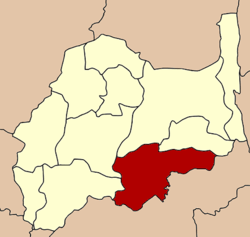 Amphoe location in Lopburi Province | |
| Coordinates: 14°51′21″N 100°59′24″E / 14.85583°N 100.99000°ECoordinates: 14°51′21″N 100°59′24″E / 14.85583°N 100.99000°E | |
| Country | Thailand |
| Province | Lopburi |
| Seat | Phatthana Nikhom |
| Area | |
| • Total | 517.0 km2 (199.6 sq mi) |
| Population (2005) | |
| • Total | 61,306 |
| • Density | 118.6/km2 (307/sq mi) |
| Time zone | UTC+7 (ICT) |
| Postal code | 15140 |
| Geocode | 1602 |
Phatthana Nikhom (Thai: พัฒนานิคม, pronounced [pʰát.tʰā.nāː ní(ʔ).kʰōm]) is a district (amphoe) of Lopburi Province in central Thailand.
Geography

Neighboring districts are (from the north clockwise) Chai Badan and Tha Luang of Lopburi Province, Muak Lek, Wang Muang, Kaeng Khoi, Chaloem Phra Kiat and Phra Phutthabat of Saraburi Province, and Mueang Lopburi and Khok Samrong of Lopburi.
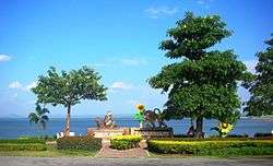
The Pa Sak Cholasit Dam that stops the Pa Sak River is in this district. Phatthana Nikhom is a favorite tourist stop due to its winter sunflower fields.
History
The district was created during the premiership of Field Marshal Plaek Phibunsongkhram.
The minor district (king amphoe) was created on 23 February 1962, when the five tambon Di Lang, Manao Wan, Khok Salung, Chong Sarika, and Nong Bua were split off from Mueang Lopburi District.[1] It was upgraded to a full district on 16 July 1963.[2]
Administration
The district is divided into nine sub-districts (tambon), which are further subdivided into 88 villages (muban). There are two townships (thesaban tambon) - Phatthana Nikhom covering parts of tambon Phatthana Nikhom and Kaeng Suea Ten covering parts of tambon Nong Bua. There are a further nine tambon administrative organizations (TAO).
| No. | Name | Thai name | Villages | Pop. | |
|---|---|---|---|---|---|
| 1. | Phatthana Nikhom | พัฒนานิคม | 14 | 12,293 | |
| 2. | Chong Sarika | ช่องสาริกา | 13 | 6,770 | |
| 3. | Manao Wan | มะนาวหวาน | 7 | 4,235 | |
| 4. | Di Lang | ดีลัง | 7 | 7,220 | |
| 5. | Khok Salung | โคกสลุง | 11 | 11,150 | |
| 6. | Chon Noi | ชอนน้อย | 6 | 2,529 | |
| 7. | Nong Bua | หนองบัว | 11 | 6,014 | |
| 8. | Huai Khun Ram | ห้วยขุนราม | 11 | 6,818 | |
| 9. | Nam Sut | น้ำสุด | 8 | 4,277 |
References
- ↑ ประกาศกระทรวงมหาดไทย เรื่อง การแบ่งท้องที่ตั้งเป็นกิ่งอำเภอ (PDF). Royal Gazette (in Thai). 79 (25 ง): 569–570. March 13, 1962.
- ↑ พระราชกฤษฎีกาตั้งอำเภอบ่อพลอย อำเภอไทรโยค อำเภอหนองปรือ อำเภอหนองสองห้อง อำเภอประทาย อำเภอห้วยแถลง อำเภอละหานทราย อำเภอกุยบุรี อำเภอตาพระยา อำเภอหนองไผ่ อำเภอนาเชือก อำเภอวัดเพลง อำเภอพนัสนิคม อำเภอภูกระดึง อำเภอปรางค์กู่ อำเภอท่าช้าง อำเภอบ้านด่านลานหอย อำเภอบ้านดุง อำเภอสว่างอารมณ์ และอำเภอกุดชุม พ.ศ. ๒๕๐๖ (PDF). Royal Gazette (in Thai). 80 (72 ก): 362–366. July 16, 1963.
External links
Lopburi | ||
|---|---|---|
| Main article |  | |
| Capital | ||
| Districts (amphoe) | ||
| Royalty | ||
| Related topics | ||
| Neighboring areas | ||