Lake Roosevelt National Recreation Area
| Lake Roosevelt | |
|---|---|
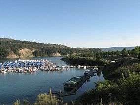 View from Two Rivers Marina | |
 | |
| Location | Ferry, Stevens, Lincoln, and Grant counties, Washington, USA |
| Nearest city | Spokane, Washington |
| Coordinates | 48°06′27″N 118°12′46″W / 48.10743°N 118.21289°WCoordinates: 48°06′27″N 118°12′46″W / 48.10743°N 118.21289°W |
| Area | 100,390 acres (406.3 km2)[3] |
| Established | April, 1946 |
| Visitors | 1,781,972 (in 2012)[4] |
| Governing body | National Park Service, U.S. Bureau of Reclamation, U.S. Bureau of Indian Affairs, Confederated Tribes of the Colville Reservation, Spokane Tribe |
| Website | Lake Roosevelt National Recreation Area |
Lake Roosevelt National Recreation Area is a U.S. National Recreation Area under the supervision of the National Park Service. It encompasses the 130-mile (210 km) long Franklin D. Roosevelt Lake between Grand Coulee Dam and Northport, Washington, in eastern Washington state. The Grand Coulee Dam was built on the Columbia River in 1941 as part of the Columbia River Basin project, named for President Franklin D. Roosevelt. Lake Roosevelt National Recreation Area provides opportunities for fishing, swimming, canoeing, boating, hunting, camping, and visiting historic Fort Spokane and St. Paul's Mission. Crescent Bay Lake in Grant County just southwest of Lake Roosevelt also falls under the jurisdiction of the National Recreation Area.

Lake Roosevelt atop Coulee Dam
References
- ↑ "Lake Roosevelt National Recreation Area (U.S. National Park Service)". www.nps.gov. Retrieved 17 April 2018.
- ↑ https://irma.nps.gov/Stats/Reports/Park/LARO
- ↑ "Listing of acreage as of December 31, 2011". Land Resource Division, National Park Service. Retrieved 2012-12-14.
- ↑ "NPS Annual Recreation Visits Report". National Park Service. Retrieved 2012-12-14.
External links
This article is issued from
Wikipedia.
The text is licensed under Creative Commons - Attribution - Sharealike.
Additional terms may apply for the media files.