Lamona, Washington
| Lamona | |
|---|---|
| Unincorporated community | |
|
Atlas 41E Missile on its way to Fairchild Air Force Base making a brief stop for school children in Lamona in 1961. | |
 Lamona Location within the state of Washington | |
| Coordinates: 47°21′34″N 118°28′53″W / 47.35944°N 118.48139°WCoordinates: 47°21′34″N 118°28′53″W / 47.35944°N 118.48139°W | |
| Country | United States |
| State | Washington |
| County | Lincoln |
| Elevation | 1,797 ft (548 m) |
| Time zone | UTC-8 (Pacific (PST)) |
| • Summer (DST) | UTC-7 (PDT) |
| ZIP codes | 99144 |
| GNIS feature ID | 1511086[1] |
Lamona is an unincorporated community located in southern Lincoln County, Washington, United States, between Odessa and Harrington on State Route 28. Lamona is located at an elevation of 1,797 feet (548 m) above sea level.[2]
Lamona was named for its first merchant, in 1892-1893, J.H. Lamona.[3]
References
- ↑ "Lamona". Geographic Names Information System. United States Geological Survey.
- ↑ "US Gazetteer files: 2010, 2000, and 1990". United States Census Bureau. 2011-02-12. Retrieved 2011-04-23.
- ↑ Meany, Edmond S. (1923). Origin of Washington geographic names. Seattle: University of Washington Press. p. 142.
Municipalities and communities of Lincoln County, Washington, United States | ||
|---|---|---|
| Cities | 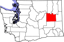 | |
| Towns | ||
| Unincorporated communities | ||
| Ghost town | ||
This article is issued from
Wikipedia.
The text is licensed under Creative Commons - Attribution - Sharealike.
Additional terms may apply for the media files.