Ili Kazakh Autonomous Prefecture
| Ili Prefecture 伊犁州 ئىلى ئوبلاستى | |
|---|---|
| Sub-provincial autonomous prefecture | |
|
Ili Kazakh Autonomous Prefecture 伊犁哈萨克自治州 ئىلى قازاق ئاپتونوم ئوبلاستى | |
 Gulja seat of Ili | |
 Ili Prefecture (red) in Xinjiang (orange) | |
| Country | People's Republic of China |
| Region | Xinjiang |
| Prefecture seat | Yining (Gulja) |
| Area | |
| • Land | 56,381.52 km2 (21,769.03 sq mi) |
| • inc. Altay & Tacheng | 268,778.71 km2 (103,776.04 sq mi) |
| Population (2015) | |
| • Total | 3,009,100 |
| • inc. Altay & Tacheng | 4,736,400 |
| Time zone | UTC+8 (China Standard) |
| ISO 3166 code | CN-XJ-40 |
| GDP (2014) |
CNY 164.0 billion US$25.2 billion (including Altay & Tacheng) |
| - per capita |
CNY 34,119 US$5,249 (including Altay & Tacheng) |
| Ili Kazakh Autonomous Prefecture | |||||||||||
| Chinese name | |||||||||||
|---|---|---|---|---|---|---|---|---|---|---|---|
| Simplified Chinese | 伊犁哈萨克自治州 | ||||||||||
| Traditional Chinese | 伊犁哈薩克自治州 | ||||||||||
| |||||||||||
| Dunganese name | |||||||||||
| Dungan | Йили Хасакə Зыҗыҗу | ||||||||||
| Romanization | Jili Xasakə Zьⱬьⱬu | ||||||||||
| Uyghur name | |||||||||||
| Uyghur |
ئىلى قازاق ئاپتونوم ئوبلاستى | ||||||||||
| |||||||||||
| Kazakh name | |||||||||||
| Kazakh |
ىله قازاق اۆتونومىيالى وبلىسى Іле Қазақ аутономиялық облысы Ile Qazaq aýtonomııalyq oblysy | ||||||||||
Ili or Ili Kazakh Autonomous Prefecture in northernmost Xinjiang is the only Kazakh autonomous prefecture in China.
Geography and coordinates
- Capital: Yining (Gulja)
- Geographic coordinates: 79º50'30″ – 84º56'50″ East, 42º14'16″ – 44º50'30″ North
The Ili Kazakh Autonomous Prefecture is west of Mongolia, south of Russia and east of Kazakhstan. Its foreign boundary is 2,000 km (1,200 mi), generally located between Altai Mountains and the main range of Tian Shan, occupying most of the Dzungarian Basin in northern Xinjiang and the Ili River Basin.
The prefecture-level city of Karamay is completely surrounded and divided by the Ili Kazakh Autonomous Prefecture but is not part of it.
The upper course of the Ili River and that of Irtysh River flow through the prefecture.
Administrative divisions
As a Sub-provincial Autonomous Prefecture, Ili Kazakh Autonomous Prefecture is administratively divided into three parts -- Altay Prefecture and Tacheng Prefectures, together with a directly administrated county-level prefecture that includes Yining City, 2 other county-level cities, 7 counties, and 1 autonomous county (see Administrative divisions of the People's Republic of China#Levels). The directly administrated region is exactly coterminous with the historical area that in the past was often called by Russians and Westerners as Kulja or Kuldja.[1]
 Ili Prefecture under its direct administration Tacheng Prefecture Altay Prefecture |
|||||||||||
| Part | Division code | Name | Chinese | Hanyu Pinyin | Uyghur (UEY) | Uyghur Latin (ULY) | Kazakh (Arabic script) | Kazakh Latin alphabet | Population (2010 Census) | Area (km²) | Density (/km²) |
|---|---|---|---|---|---|---|---|---|---|---|---|
| Ili Prefecture (direct administration) |
654002 | Yining[2] | 伊宁市 | Yīníng Shì | غۇلجا شەھىرى | Ghulja Shehiri | قۇلجا قالاسى | Qulja qalasy | 515,082 | 629 | 818.89 |
| 654003 | Kuytun[2] | 奎屯市 | Kuítún Shì | كۈيتۇن شەھىرى | Küytun Shehiri | كۇيتۇن قالاسى | Ku'i'tu'n qalasy | 166,261 | 1,171 | 141.98 | |
| 654004 | Korgas[2] | 霍尔果斯市 | Huò'ěrguǒsī Shì | قورغاس شەھىرى | Qorghas Shehiri | قالاسى قورعاس | Qorg'as qalasy | 85,000(?) | 1,900 | 44.73 | |
| 654021 | Yining County[2] | 伊宁县 | Yīníng Xiàn | غۇلجا ناھىيىسى | Ghulja Nahiyisi | قۇلجا اۋدانى | Qulja ay'dany | 372,590 | 4,486 | 83.05 | |
| 654020 | Qapqal Xibe Autonomous County | 察布查尔锡伯自治县 | Chábùchá'ěr Xībó Zìzhìxiàn | چاپچال شىبە ئاپتونوم ناھىيىسى | Chapchal Shibe Aptonom Nahiyisi | شاپشال سىبە اۆتونوميالى اۋدانى | S'aps'al Sibe avtonomi'aly ay'dany | 179,744 | 4,489 | 40.04 | |
| 654023 | Huocheng County[2] | 霍城县 | Huòchéng Xiàn | قورغاس ناھىيىسى | Qorghas Nahiyisi | قورعاس اۋدانى | Qorg'as ay'dany | 352,689 | 5,466 | 64.52 | |
| 654024 | Gongliu County[2] | 巩留县 | Gǒngliú Xiàn | توققۇزتارا ناھىيىسى | Toqquztara Nahiyisi | توعىزتاراۋ اۋدانى | Tog'yztaray' ay'dany | 164,860 | 4,124 | 39.97 | |
| 654025 | Xinyuan County[2] | 新源县 | Xīnyuán Xiàn | كۈنەس ناھىيىسى | Künes Nahiyisi | كۇنەس اۋدانى | Ku'nes ay'dany | 282,718 | 7,583 | 37.28 | |
| 654026 | Zhaosu County[2] | 昭苏县 | Zhāosū Xiàn | موڭغۇلكۈرە ناھىيىسى | Mongghulküre Nahiyisi | موڭعۇلكۇرە اۋدانى | Mon'g'ulku're ay'dany | 148,187 | 10,465 | 14.16 | |
| 654027 | Tekes County | 特克斯县 | Tèkèsī Xiàn | تېكەس ناھىيىسى | Tëkes Nahiyisi | تەكەس اۋدانى | Tekes ay'dany | 142,713 | 8,080 | 17.66 | |
| 654028 | Nilka County | 尼勒克县 | Nílèkè Xiàn | نىلقا ناھىيىسى | Nilqa Nahiyisi | نىلقى اۋدانى | Nylqy ay'dany | 157,743 | 10,130 | 15.57 | |
| ↪ Altay Prefecture | 阿勒泰地区 | Ālètài Dìqū | ئالتاي ۋىلايىتى | Altay Wilayiti | التاي ايماعى | Altai' ai'mag'y | 603,283 | 117,800 | 5.12 | ||
| ↪ Tacheng Prefecture[2] | 塔城地区 | Tǎchéng Dìqū | تارباغاتاي ۋىلايىتى | Tarbaghatay Wilayiti | تارباعاتاي ايماعى | Tarbag'atai' ai'mag'y | 1,219,369 | 104,546 | 11.66 | ||
History
Early history
Before the advent of the Qin dynasty (221 BC – 206 BC), Ili was occupied by the Ussuns, a tributary tribe of the Huns. The Ussuns were driven away in the 6th century AD by the northern Xiongnu, who established the Turkic Khaganate in 552. Later this Khulja territory became a dependency of Dzungaria. During the Tang dynasty (618–907), the khanate became the Protectorate General to Pacify the West of the Tang Empire.
The Uyghur Khaganate, and in the 12th century the Kara-Khitai, took possession of the area in turn. Genghis Khan conquered Kulja in the 13th century, and the Mongol Khans resided in the valley of the Ili. It is supposed that the Oirats conquered it at the end of the 16th or the beginning of the 17th century.
Qing dynasty
The Oirats, or more precisely Dzungars, controlled both Dzungaria and the Ili Basin until 1755 as the Dzungar Khanate, when it was annexed by the Manchu-run Qing dynasty under the Qianlong Emperor. Having defeated the Dzungars in the Dzungarian and Ili Basins, as well as the Afaqi Khojas in Kashgaria, the Qing court decided to make the Ili basin the main base of their control in Xinjiang.
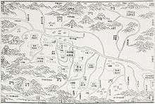
In the 1760s, the Qing built nine fortified towns (九城) in the Ili Basin:
| Original Chinese name | Chinese | Turki (Uyghur) name[3] | Modern name of the location[4] | Notes |
|---|---|---|---|---|
| Huiyuan Cheng | 惠远城 | Kürä Shahr | Huiyuan Town (惠远镇) in Huocheng County | The Old Huiyuan was the residence of the General of Ili from 1765 to 1866. The New Huiyuan was the residence of the General of Ili from 1894 to 1912. Also known as New Kulja, Manchu Kulja, or Ili at the time. |
| Ningyuan Cheng | 宁远城 | Kulja (Ghulja) | Yining City | Also was known as Old Kulja or Taranchi Kulja. County seat of Ningyuan County (1888–1914) and Yining County (1914–1952) |
| Huining Cheng | 惠宁城 | Bayandai | Bayandai Town (巴彦岱镇) within Yining City, some 10[5] to 18[6] km to the west of the Yining center city | |
| Taleqi Cheng | 塔勒奇城 | Tarchi | Within Huocheng County | |
| Zhande Cheng | 瞻德城 | Chaghan Usu | Qingshuihe Town (清水河镇) in Huocheng County | |
| Guangren Cheng | 广仁城 | Ukurborosuk | Lucaogou Town (芦草沟镇) in Huocheng County, NE of Qingshuihe | |
| Gongchen Cheng | 拱宸城 | Khorgos | Khorgas City (霍尔果斯市) | |
| Xichun Cheng | 熙春城 | Khara Bulaq | Area commonly referred to as Chengpanzi (城盘子) in the Hanbin Township (汉宾乡) within Yining City, a few km west of the city center | |
| Suiding Cheng | 绥定城 | Ukharliq | Shuiding Town (水定镇), county seat of Huocheng County since 1966 | General of Ili's residence 1762–1765 and 1883–1894, when it became known as New/Manchu/Chinese Kulja. County seat of Suiding County (1888–1965) and Shuiding County (1965–1966). Renamed Shuiding in 1965. |
Huiyuan Cheng, as the seat of the General of Ili, the chief commander of the Qing troops in Xinjiang, became the administrative capital of the region. It was provided with a large penal establishment and a strong garrison. This city was called New Kulja, Manhcu Kulja, Chinese Kulja, or Ili by the Russians and Westerners, to distinguish it from Nigyuan/Yining, known as Old Kulja or Taranchi Kulja.
The first General of Ili was Ming Rui. The Qing tradition, unbroken until the days of Zuo Zongtang in the 1870s, was to only appoint Manchus as officials in Xinjiang.
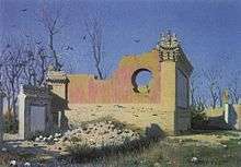
During the insurrection of 1864 the Dungans and Taranchis of the area formed the Taranchi Sultanate. Huiyuan (Manchu Kulja) was the last Qing fortress in the Ili Valley to fall to the rebels. The insurgent Dungans massacred most of Manchu Kulja's inhabitants; Governor General Mingsioi (Ming Xü) assembled his family and staff in his mansion, and blew it up, dying under its ruins.
The sultanate led to the occupation of the Ili basin (Kulja in contemporary Western terms) by the Russians in 1871. Ten years later the territory was restored to China, and its boundary with Russia was assigned in accordance to the Treaty of Saint Petersburg (1881).
After Chinese authority was restored, a new Huiyuan Town was built, some 4 km (2.5 mi) north of the old Huiyuan site.
On January 7, 1912, Yang Cuanxu of Ili occupied Huiyuan Town and shot the last Qing General of Ili, Zhi Rui.
The Republic of China
In July 1945, Chingil, Bole and Quanxi (精河、博乐、温泉) of Ili were made into a new autonomous prefecture now not part of Ili: Bortala.
The People's Republic of China
In 1949, Ili was made a special area (专区) of Xinjiang, with one city and nine counties, and was upgraded to a city in 1952. On November 27, 1954, the Ili Autonomous Prefecture was established to include the prefectures of Ili, Altay, and Tacheng. The Ili Prefecture was abolished in 1955. Its one city and nine counties are now under the direct control of the autonomous prefecture.
Tourism
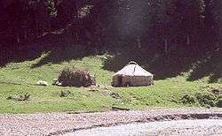
Ili Kazakh Autonomous Prefecture is a famous tourist destination for its relatively humid climate, which earned its reputation as 'wetland in Central Asia'. Major tourist attractions include Narati Grassland, Guozigou and Kanas Lake. In 2015 alone, Ili has seen over 25 million travellers and earned over 19 billion CNY (US$2.92 billion) tourism receipts.[7]
Transport
Road and Railway
An extensive road network is being built across the prefecture for economic development. In 2015, 66 million passengers travelled on road.
The railway has extended to both the very north part of Altay City and the westmost city of Khorgas on the China-Kazakhstan border.
Border crossings
Ili Kazak's 8 functioning ports of entry are:
- With Kazakhstan
- Aqimbek (阿黑木别克) of Altay Prefecture
- Bakhtu (巴克图), 17 km (11 mi) from Tacheng; another primary point or port
- Dulat (都拉塔), in Qapqal Xibe Autonomous County: under Ili
- Jeminay (吉木乃) of Altay Prefecture;another primary point or port
- Khorgas (霍尔果斯), in Huocheng County; under Ili; a primary Chinese "national" border crossing point or port of entry
- Muzart (木扎尔特), in Zhaosu County: directly controlled by Ili; another primary point or port
- With Mongolia
- Khiziltaw (红山嘴) of Altay Prefecture
- Taskhin (塔克什肯) of Altay Prefecture to Khovd
- Dayan-Khunshanzyui of Altay Prefecture to Bayan-Ölgii. Only open during Summer.
See also
References
Citations
- ↑ Encyclopædia Britannica. 1911.
- 1 2 3 4 5 6 7 8 9 The official spelling according to Zhōngguó dìmínglù 中国地名录 (Beijing, SinoMaps Press 中国地图出版社 1997); ISBN 7-5031-1718-4
- ↑ As per Kim (2004), pp. 54, 229
- ↑ Info from Chinese Wikipedia and Yining County Historical Development Archived 2007-01-06 at the Wayback Machine.
- ↑ Direct distance from modern maps
- ↑ Road distance from Lansdell (1885), p. 190
- ↑ "National Data". Retrieved 18 April 2016.
Sources
- Henry Lansdell, "Russian Central Asia: Including Kuldja, Bokhara, Khiva and Merv". Full text available at Google Books; there is also a 2001 facsimile reprint of the 1885 edition, ISBN 1-4021-7762-3. (Chapters XIV-XVI describe Lansdell visit to the area in the early 1880s, soon after the Russian withdrawal). (in English)
External links
| Wikimedia Commons has media related to Ili Kazakh Autonomous Prefecture. |
- Official site (in Simplified Chinese)
- Subdivision info (in Simplified Chinese)
- A TALE OF TWO CITIES: NEW MUSEUMS FOR YINING AND URUMQI "CHINA HERITAGE NEWSLETTER", China Heritage Project, The Australian National University. ISSN 1833-8461. No. 3, September 2005. (Talks about Ili Kazak Autonomous Prefecture Museum in Yining).
Coordinates: 44°26′59″N 84°59′09″E / 44.44972°N 84.98583°E