Demographics
According to the 2000 census, Bayingolin has 1,056,970 inhabitants (population density: 2.28 per km²).
Ethnic groups in Bayingolin
When Bayingolin was first established in 1954, it was an area with the Mongols comprising 35% of the prefecture's population.[2] Due to steady immigration, the Han Chinese population has also increased significantly. In 1947, there were reportedly only 1,682 Han Chinese in Xinjiang's Eighth District (roughly corresponding to today's Bayingolin in area), and that increased to over 660,000 in 2004.[3][4]
- Population by ethnicity
| Nationality |
2000[5] |
2010[6] |
| Population |
% |
Population |
% |
| Han Chinese |
607,774 |
57.5% |
757,983 |
59.29% |
| Uyghur |
345,595 |
32.7% |
406,942 |
31.83% |
| Hui |
52,252 |
4.94% |
60,451 |
4.73% |
| Mongol |
43,544 |
4.12% |
43,484 |
3.40% |
| Tujia |
|
|
2,336 |
0.18% |
| Miao |
|
|
1,362 |
0.11% |
| Dongxiang |
|
|
1,148 |
0.09% |
| Kazakhs |
|
|
1,091 |
0.09% |
| Manchu |
|
|
888 |
0.07% |
| Other |
7,805 |
0.74% |
2,801 |
0.22% |
| Total |
1,046,970 |
100% |
1,278,486 |
100% |
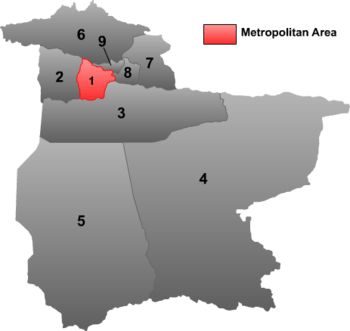
Subdivisions
Bayin'gholin directly controls 1 county-level city, 7 counties and 1 Hui autonomous county.
 |
| # |
Name |
Simplified Chinese |
Hanyu Pinyin |
Uyghur (UEY) |
Uyghur Latin (ULY) |
Mongolian |
Population (2010 Census) |
Area (km²) |
Density (/km²) |
| 1 |
Korla[7] |
库尔勒市 |
Kù'ěrlè Shì |
كورلا شەھىرى |
Korla Shehiri |
ᠬᠣᠷᠣᠯ ᠬᠣᠲᠠ |
549,324 |
7,219 |
76.09 |
| 2 |
Luntai County[7] |
轮台县 |
Lúntái Xiàn |
بۈگۈر ناھىيىسى |
Bügür Nahiyisi |
ᠪᠦᠭᠦᠷ ᠰᠢᠶᠠᠨ |
116,166 |
14,185 |
8.18 |
| 3 |
Yuli County[7] |
尉犁县 |
Yùlí Xiàn |
لوپنۇر ناھىيىسى |
Lopnur Nahiyisi |
ᠯᠣᠪᠨᠠᠭᠤᠷ ᠰᠢᠶᠠᠨ |
96,068 |
59,402 |
1.61 |
| 4 |
Ruoqiang County[7] |
若羌县 |
Ruòqiāng Xiàn |
چاقىلىق ناھىيىسى |
Chaqiliq Nahiyisi |
ᠴᠠᠺᠢᠯᠢᠺ ᠰᠢᠶᠠ |
35,580 |
199,222 |
0.17 |
| 5 |
Qiemo County[7] |
且末县 |
Qiěmò Xiàn |
چەرچەن ناھىيىسى |
Cherchen Nahiyisi |
ᠴᠧᠷᠴᠧᠨ ᠰᠢᠶᠠᠨ |
65,572 |
138,680 |
0.47 |
| 6 |
Hejing County[7] |
和静县 |
Héjìng Xiàn |
خېجىڭ ناھىيىسى |
Xéjing Nahiyisi |
ᠬᠡᠵᠢᠨ ᠰᠢᠶᠠᠨ |
160,804 |
34,984 |
4.59 |
| 7 |
Hoxud County[7] |
和硕县 |
Héshuò Xiàn |
خوشۇت ناھىيىسى |
Xoshut Nahiyisi |
ᠬᠣᠱᠤᠳ ᠰᠢᠶᠠᠨ |
72,556 |
12,754 |
5.68 |
| 8 |
Bohu County[7] |
博湖县 |
Bóhú Xiàn |
باغراش ناھىيىسى |
Baghrash Nahiyisi |
ᠪᠣᠰᠲᠠᠨᠠᠭᠤᠷ ᠰᠢᠶᠠᠨ |
54,788 |
3,597 |
15.23 |
| 9 |
Yanqi Hui Autonomous County |
焉耆回族自治县 |
Yānqí Huízú Zìzhìxiàn |
يەنجى خۇيزۇ ئاپتونوم ناھىيىسى |
Yenji Xuyzu Aptonom Nahiyisi |
ᠶᠠᠨᠼᠢ ᠬᠣᠲᠣᠩ ᠥᠪᠡᠷᠲᠡᠭᠡᠨ ᠵᠠᠰᠠᠬᠤ ᠰᠢᠶᠠᠨ |
127,628 |
2,429 |
52.54 |
References
- ↑ The official spelling is "Bayingolin" according to Zhōngguó Dìmínglù (in simplified Chinese) (Beijing, SinoMaps Press 中国地图出版社 1997);
ISBN 7-5031-1718-4; p. 300.
- ↑ Atwood, Christopher (2004). Encyclopedia of Mongolia and the Mongol Empire. Facts on File. p. 39.
- ↑ Gardner Bovingdon (2010). "Chapter 2 - Heteronomy and Its Discontents". The Uyghurs - strangers in their own land. Columbia University Press. ISBN 978-0-231-14758-3.
- ↑ Bovingdon, Gardner (2010). "Note 9 (Chapter 2)". The Uyghurs - strangers in their own land. Columbia University Press. ISBN 978-0-231-14758-3.
- ↑ 2000年人口普查中国民族人口资料,民族出版社,2003/9 (
ISBN 7-105-05425-5)
- ↑ Stanley W. Toops (August 2012). Susan M. Walcott; Corey Johnson, eds. Eurasian Corridors of Interconnection: From the South China to the Caspian Sea. Routledge. pp. 65–66. ISBN 978-1135078751.
- 1 2 3 4 5 6 7 8 The official spelling according to Zhōngguó dìmínglù 中国地名录 (Beijing, SinoMaps Press 中国地图出版社 1997);
ISBN 7-5031-1718-4