Qapqal Xibe Autonomous County
| Qapqal County 察布查尔县 • ᠴᠠᠪᠴᠠᠯ ᠰᡳᠶᠠᠨ | |
|---|---|
| Autonomous county | |
|
察布查尔锡伯自治县 ᠴᠠᠪᠴᠠᠯ ᠰᡞᠪᡝ ᠪᡝᠶᡝ ᡩᠠᠰᠠᡢᡤᠠ ᠰᡞᠶᠠᠨ Qapqal Xibe Autonomous County | |
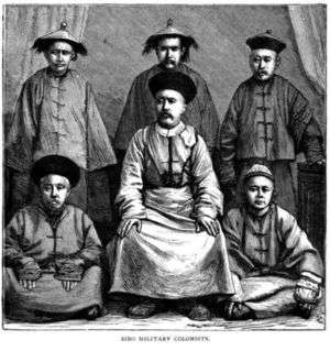 "Sibo military colonists", picture drawn during Henry Lansdell visit to today's Qapqal County in 1882 | |
.png) Location of Qapqal Xibe Autonomous County (pink) in Ili Kazakh Autonomous Prefecture | |
| Country | People's Republic of China |
| Autonomous region | Xinjiang |
| Autonomous prefecture | Ili |
| Area | |
| • Total | 4,430 km2 (1,710 sq mi) |
| Population (2000) | |
| • Total | 160,000 |
| • Density | 36/km2 (94/sq mi) |
| Time zone | UTC+8 (CST) |
| Qapqal Xibe Autonomous County | |||||||
| Traditional Chinese | 察布查爾錫伯自治縣 | ||||||
|---|---|---|---|---|---|---|---|
| Simplified Chinese | 察布查尔锡伯自治县 | ||||||
| |||||||
| Alternative Chinese name | |||||||
| Traditional Chinese | 寧西縣 | ||||||
| Simplified Chinese | 宁西县 | ||||||
| |||||||
Qapqal Xibe Autonomous County (; Xibe:ᠴᠠᠪᠴᠠᠯ
ᠰᡞᠪᡝ
ᠪᡝᠶᡝ
ᡩᠠᠰᠠᡢᡤᠠ
ᠰᡞᠶᠠᠨ Cabcal Sibe beye dasangga siyan, also transliterated as Chapchal, Uyghur: Чапчал Шибә Аптоном Наһийиси, Kazakh: S'aps'al Si'be ay'tonomyi'alyq ay'dany) in Ili Kazakh Autonomous Prefecture in northern Xinjiang is the only Xibe autonomous county of the People's Republic of China, bordering Kazakhstan's Almaty Region to the west. It has an area of 4,430 square kilometers and a population 160,000 (2000). Qapqal means "the granary" in the Xibe language.
Subdivisions
The Xibe, sent to garrison the area by the Qing Dynasty, were divided into eight niru (companies); each niru established a settlement. The settlements are thus simply referred to as "First Niru" through "Eighth Niru", with the exception of the settlement established by the Sixth, which came to be known as Qapqal, thus giving the county its name.[1]
| Number[1] | Xibe name[1] | Chinese name | % Xibe[1] | % Han[1] | % Other[1] | Population | Number of villages | Source |
|---|---|---|---|---|---|---|---|---|
| 1 | Uju Niru | 61.8 | 20.9 | 17.3 | ||||
| 2 | Jai Niru | 72.2 | 15.5 | 12.3 | ||||
| 3 | Ilaci Niru | 73.2 | 12.3 | 14.5 | ||||
| 4 | Duici Niru | 32.9 | 28.4 | 38.7 | ||||
| 5 | Sunjaci Niru | 孙扎齐乡 | 38.2 | 15 | 46.8 | 8033 | 4 | [2] |
| 6 | Ningguci Niru, or Capcal | 29 | 32 | 39 | ||||
| 7 | Nadaci Niru | 41.6 | 32 | 24.6 | ||||
| 8 | Jakûci Niru | 扎库齐牛录乡 | 72.2 | 15.5 | 12.3 | 13,000 | 5 | [3] |
Media
The county has one Xibe-language newspaper, the Qapqal News. A television station broadcasts a few programmes in Xibe as well each month, with Chinese-language content the rest of the time.[4]
References
- 1 2 3 4 5 6 Stary, Giovanni (2003), "Sibe: An endangered language", in Janse, Mark; Tol, Sijmen; Hendriks, Vincent, Language death and language maintenance, John Benjamins, pp. 81&ndash, 89, ISBN 978-90-272-4752-0
- ↑ "察布查尔县孙扎齐乡", Qapqal Online, retrieved 2009-04-15
- ↑ "察布查尔县扎库齐牛录乡", Qapqal Online, retrieved 2009-04-15
- ↑ 张莉 [Zhang Li] (2007), 新疆锡伯族新闻事业发展现状 [Xinjiang Xibo Peoples' News Undertaking Present Situation], 《伊犁师范学院学报》 [Journal of Ili Normal University] (1), ISSN 1009-1076, archived from the original on 2011-07-07, retrieved 2009-04-13
External links
- County info page, at an Ili Kazak Autonomous Prefecture info site
Coordinates: 43°48′07″N 81°05′14″E / 43.80194°N 81.08722°E