Qianxinan Buyei and Miao Autonomous Prefecture
| Qianxinan Prefecture 黔西南州 · Qianfxiynanf zouy · Qeef Xib Naif Zeb | |
|---|---|
| Autonomous Prefecture | |
|
黔西南布依族苗族自治州 Qianxinan Buyei and Miao Autonomous Prefecture | |
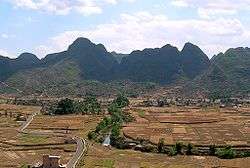 Wan Feng Lin River near Xingyi | |
.png) Location of Qianxinan Buyei and Miao Autonomous Prefecture within Guizhou | |
| Country | People's Republic of China |
| Province | Guizhou |
| Area | |
| • Total | 16,804 km2 (6,488 sq mi) |
| Population (2003) | |
| • Total | 3,059,400 |
| Time zone | UTC+8 (China Standard) |
| ISO 3166 code | CN-GZ-23 |
Qianxinan Buyei and Miao Autonomous Prefecture (Chinese: 黔西南布依族苗族自治州[1]; pinyin: Qiánxīnán Bùyīzú Miáozú Zìzhìzhōu[2]; Buyei: Qianfxiynanf Buxqyaix Buxyeeuz Ziqziqzouy), a.k.a. Hsing-i Chuan-ch’ü[3] and Hsing-i Ti-ch’ü[4] is an autonomous prefecture of Guizhou province, People's Republic of China, bordering Guangxi to the south and Yunnan to the west. The name, "黔西南" derives from the prefecture's southwest location in the province; "黔" is the official abbreviation for Guizhou, while "西南" means "southwest".
Subdivisions
The prefecture is subdivided into 8 county-level divisions: 2 county-level city and 6 counties。
- county level city:
- county:
- Wangmo County (望谟县)
- Pu'an County (普安县)
- Ceheng County (册亨县)
- Qinglong County (晴隆县)
- Zhenfeng County (贞丰县)
- Anlong County (安龙县)
| Map |
|---|

References
- ↑ "黔西南布依族苗族自治州: China". Geographical Names. Retrieved 2013-11-19.
- ↑ "Qianxinan Bouyeizu Miaozu Zizhizhou: China". Geographical Names. Retrieved 2013-11-19.
- ↑ "Hsing-i Chuan-ch'ü: China". Geographical Names. Retrieved 2013-11-19.
- ↑ "Hsing-i Ti-ch'ü: China". Geographical Names. Retrieved 2013-11-19.
Coordinates: 25°05′00″N 104°54′00″E / 25.0833°N 104.9°E
This article is issued from
Wikipedia.
The text is licensed under Creative Commons - Attribution - Sharealike.
Additional terms may apply for the media files.