Dehong Dai and Jingpo Autonomous Prefecture
| Dehong Prefecture 德宏州 | |
|---|---|
| Autonomous prefecture | |
|
Dehong Dai and Jingpo Autonomous Prefecture 德宏傣族景颇族自治州 | |
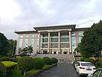 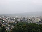 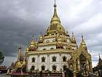 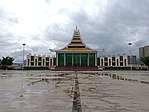 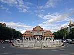 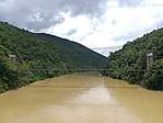 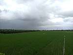 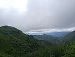 From top, left to right: Dehong Prefecture government hall, skyline of Mangshi, Menghuan Pagoda, Mangshi Square with China-Myanmar Friendship Memorial Hall, Ruili Border Port, Shweli River, farm in Ruili, mountains in Mangshi | |
| Etymology: Tai Nuea language (ᥖᥬᥲ ᥑᥨᥒᥰ), meaning "the lower reaches of the Nu River" | |
| Nickname(s): hometown of peafowl | |
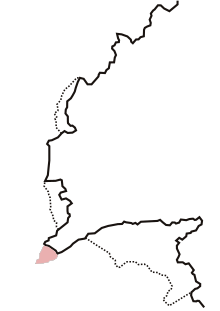
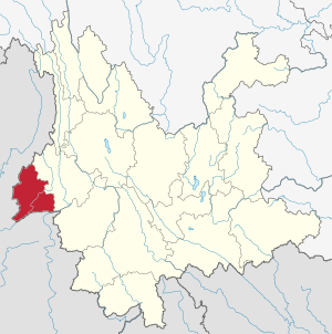 Dehong in Yunnan | |
| Coordinates: 24°26′N 98°35′E / 24.433°N 98.583°ECoordinates: 24°26′N 98°35′E / 24.433°N 98.583°E | |
| Country | People's Republic of China |
| Province | Yunnan |
| Founded | 24 July 1953 |
| Seat | Mangshi |
| Divisions | |
| Government | |
| • Prefecture governor | Wei Gang (卫岗)[1] (CPC) |
| • Secretary of CPC Prefecture Committee | Wang Junqiang (王俊强)[2] |
| Area[3]:536 | |
| • Total | 11,172.24 km2 (4,313.63 sq mi) |
| Area rank | 16 |
| Dimensions[4]:97 | |
| • Length | 170 km (110 mi) |
| • Width | 122 km (76 mi) |
| Elevation[4]:106 (Mangshi) | 920 m (3,020 ft) |
| Highest elevation[4]:106 (Daniang Mount (大娘山), north of Yingjiang County) | 3,404.6 m (11,169.9 ft) |
| Lowest elevation[4]:106 (river valley of Jieyang (羯羊河), west of Yingjiang County) | 210 m (690 ft) |
| Population (2010 census)[5]:6 | |
| • Total | 1,211,440 |
| • Estimate (2016)[6]:38 | 1,294,000 |
| • Rank | 13 |
| • Density | 110/km2 (280/sq mi) |
| • Density rank | 9 |
| Ethnics[6]:38 | |
| • Han Chinese | 704,000 - 52.24% |
| • Dai | 368,100 - 28.45% |
| • Jingpo | 141,200 - 10.91% |
| • Lisu | 33,400 - 2.58% |
| • Achang | 32,100 - 2.48% |
| • Palaung (De'ang) | 15,200 - 1.17% |
| Sex[5]:101-160 | |
| • male | 624,774 - 51.57% |
| • female | 586,666 - 48.43% |
| Time zone | UTC+8 |
| Postal code | 678400 |
| Area code(s) | (0)692 |
| ISO 3166 code | CN-YN-31 |
| Vehicle registration | 云N |
| Website |
www |
| Dehong Dai and Jingpo Autonomous Prefecture | |||||||
| Chinese name | |||||||
|---|---|---|---|---|---|---|---|
| Simplified Chinese | 德宏傣族景颇族自治州 | ||||||
| Traditional Chinese | 德宏傣族景頗族自治州 | ||||||
| |||||||
| Burmese name | |||||||
| Burmese | တယ်ဟုန် တိုင် နှင့် ဂျိမ်းဖော ကိုယ်ပိုင်အုပ်ချုပ်ခွင့်ရ ခရိုင် ကြီးများ | ||||||
| Tai Nuea name | |||||||
| Tai Nuea | ᥟᥪᥒᥱ ᥙᥪᥴ ᥓᥝᥲ ᥙᥩᥒ ᥛᥥᥝᥰ ᥖᥭᥰ ᥓᥤᥒ ᥚᥨᥲ ᥖᥬᥲ ᥑᥨᥒᥰ | ||||||
| Jingpho name | |||||||
| Jingpho | Sakhkung Sam Jinghpo Amyu Madu Uphkang Mungdo | ||||||
| Zaiwa name | |||||||
| Zaiwa | Sikung Sam Zaizo Byumyu Yumsing Upkang Mau | ||||||
The Dehong Dai and Jingpo Autonomous Prefecture is located in western Yunnan province, People's Republic of China, and is one of the eight autonomous prefectures of the province, bordering Baoshan to the east and Burma's Kachin State to the west.
Etymology
Tai Nuea is the origin language of the word "Dehong", in Tai Le script (the script used to write the Tai Nüa language) is written as "ᥖᥬᥳ ᥑᥨᥒᥰ", transliterate to Latin as "Taue Xoong". Dehong means the lower reaches of the Nu River.[7]:38
History
Early history
Dianyue, Ailao were the ancient countries recorded in Chinese literatures in Dehong area, and Guozhanbi (Kawsampi) was an ancient country established by Dai people and recorded in Dai legend. But these countries are all in controversy.
Dianyue
In the famous history book Records of the Grand Historian which written by Sima Qian in Han dynasty, a paragraph in volume 123 describe: when Zhang Qian visited Daxia in Central Asia, he found some merchandise was produced in Sichuan. And Daxia merchant said that was purchase from Yuandu (India). There was a trade route, Shu-Yuandu Road (蜀身毒道) between Yuandu and Sichuan. The road was passed a kingdom named "Dianyue" (滇越).[8] The country in modern literatures is also called "Dianyue Chengxiang"(滇越乘象国).[6]:37Chinese historian generally considered Tengyue is the center of Dianyue Chengxiang, and the territory include Dehong area. But some historian disagree this opinion, Lou Zichang (娄自昌, a historian of Wenshan College) believes Dianyue Chengxiang was not a country in western Yunnan, even not a country established by Dai people.[9]
Ailao
Ailao (哀牢) is an ancient tribal alliance country in west of Yunnan during Spring and Autumn to Eastern Han period, and modern historian generally considered the area of Ailao is include Dehong. In Chronicles of Huayang, the record of Ailao "3,000 li from west to east, and 4,600 li from south to north",[10] approximately equal 1,300 km west to east and 1,994 km south to north in modern unit.[11] It include the southwest of Yunnan and most of Myanmar, in modern research is called the generalized area of Ailao. In Han period, there were many of small tribal country in these area, Ailao is the most influential state, even the tribe of Ailao had a population of no more than 20,000.[11] The tribes in these area were nominally belong to Ailao, but the king of Ailao could not have effective control for the tribes. Baoshan historian Xiao Zhengwei (肖正伟) believes the kingdom of "Dianyue" is a powerful tribe under Ailao.[12]
And in 69 AD, the king of Ailao, Liu Mao (柳貌) lead the tribal alliance surrender to Han dynasty. Han set the county of Ailao in this area.[13] In Southern dynasty Qi period changed the name to "Xicheng County" (西城县), the seat of county was in modern Yingjiang County territory.[14]:1950 Finally in the end of Liang dynasty, the Xicheng County was abolished.[14]:933
Guozhanbi
In 568 BC to 424 BC, during the Eastern Zhou dynasty in China, ancestors of Dai people had settled in Shweli River valley area and entered the tribal period. In 364 BC, a grand chief Gelaba (葛拉叭) unified the tribes in Shweli basin. He became the chief of the tribal alliance and set the capital at Hansa (喊萨, in modern Ruili). It was the embryonic form of the kingdom of "Guozhanbi"(果占璧), also called "Kawsampi" (憍赏弥). In 364 AD, a descendant of Gelaba named Zhaowuding (召武定) inherited the throne. He is the famous deity, sovereign, and culture hero of Dai people.[15]:5 In 7 century, Dai area was in chaotic period, the descendants of Zhaowuding could not effectively control the area. At same time the kingdom of Nanzhao was rising up, and conquered Dehong area. Piluoge, the king of Nanzhao canonized another Dai tribe chief Hundeng (混等) to be the "King of Mong Mao" and managed the whole Dai area in 762.[16]:28-29
In 1995, Dehong historian Yang Yongsheng (杨永生) published a research of ancient Dai civilization. He put forward a new opinion during the Dai legend research: "Kingdom of Daguang" (达光王国) is the first state of Dai people which established in 424 BC, and the country "Dianyue Chengxiang" is the kingdom of "Daguang". In 233, capital of Daguang moved to Pagan, finally perished in 586.[17] But the history professor of Yunnan University He Ping (何平) doesn't approval it, he determined the Kingdom of Daguang is the legend kingdom of Tagaung in Burmese history, there was not a Kingdom of "Daguang" in ancient Dai civilization. The Dai legend of Daguang is the story of pre period of Pyu city-states. The story of Pyu city-states spread to Dehong Dai area, localized to a Dai legend and was recorded in Dai literatures.[18]
In Yang Yongsheng's research, the kingdom of "Guozhanbi" was the second kingdom established by Dai people after Daguang. Dai languages literatures were his sources of research. He determined the kingdom of Guozhanbi was existed from 567 to 1488. According to the research of He Ping, "Guozhanbi" is the ancient state "Kawsampi". There are many of legends about Kawsampi in Thai-Shan folks culture, no limited in Dehong area. And the origin of the legend was a story in Buddhist texts. Therefore He Ping thought the Kingdom of "Guozhanbi" or "Kawsampi" is untrustworthy history.[19]
Medieval
Whether or not the early history of Dehong is controversial, it can be determined that Dehong was belong Nanzhao and Dali in medieval period Yunnan. In Nanzhao was separated under "Yongchang Jiedu" (永昌节度, south of Dehong) and "Lishui Jiedu" (丽水节度, north of Dehong).[4]:10 In Dali was under the division of "Zhenxi Zhen" (镇西镇).[20]:115
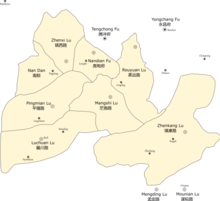
In 1253, Kublai conquer the Dali Kingdom, Dehong Dai people capitulated to Mongol Empire. Mongol set an administrative division named "Jinchi Anfu Si" (金齿安抚司) to manage west of Yunnan. In 1276, Yuan dynasty, the Anfu Si was upgraded to "Jinchi Xuanfu Si" (金齿宣抚司), and set an agency "6 Lu general manager Fu" (六路总管府) to managed Dehong area. The 6 Lu were: Luchuan Lu (麓川路, modern Ruili and Longchuan), Pingmian Lu (平缅路, modern southern Lianghe and northern Longchuan), Zhenxi Lu (镇西路, modern Yingjiang), Zhenkang Lu (镇康路, modern Zhenkang, out of Dehong), Mangshi Lu (茫施路, modern Mangshi) and Rouyuan Lu (柔远路, modern Lujiang, out of Dehong). In addition set a special division "Nan Dan" (南赕) and Nandian Fu (南甸府, modern Lianghe). The scope of "6 Lu general manager Fu" is close to modern Dehong territory.[4]:11
In 1277, Narathihapate who was the king of Burmese Pagan Kingdom invaded modern Dehong area. The Battle of Ngasaunggyan was happened on the bank of Taping River in nowadays Yingjiang County. The Yuan army only had 700 soldiers but finally repelled Burmese military of 40,000 to 50,000 soldiers with 10,000 horses and 800 elephants.[21]:104 It was the prelude of First Mongol invasion of Burma.[22]:26-27
It is worth mentioning that, Dehong Dai people immigrated to modern Assam in India during 13 to 14 centuries and then built up the kingdom of Ahom. It formed the latter-day Ahom people.[23]
Mong Mao
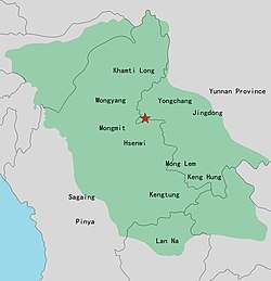
Local Dai chief was the leader of Luchuan Lu, they were the successors of "Guozhanbi". "Luchuan" is the name that Yuan called, and "Mong Mao" is the self-call by the regime, they were same thing.[24] Si Kefa enthroned the chieftain of Luchuan Lu in 1340[25] and sent troops annexed the state of Hsenwi, Mongyang, Mongmit. After that he attacked Mangshi, Zhenxi, Pingmian and Nandian. So the Yuan dynasty initisate several times wars in 1342, 1345, 1346 and 1347 to counterattack Luchuan, but they all failed. Then Luchuan conquered surrounding states successively. In 1355, Si Kefa requested Yuan dynasty to canonize him. Yuan central government admitted his local regime and canonized Si Kefa to be the first Mong Mao Tusi. Central government set a division "Pingmian Xuanwei Si" (平缅宣慰司) at Mong Mao to let the regime legalization. Mong Mao tusi is the leader of Xuanwei Si.[15]:9-10
In 1382, Ming dynasty military arrived at Mong Mao, tusi Si Lunfa surrendered. Ming granted him a title "Xuanwei Commissioner of Luchuan Pingmian" (麓川平缅宣慰使) and changed the division to "Luchuan Pingmian Xuanwei Si". In 1385, the contradiction occurred. The leader of Jingdong renegaded Mong Mao regime, Si Lunfa sent troops attacked Jingdong.[26] But Mu Ying, the general of Yunnan was protecting Jingdong leader. So the wars between Mong Mao regime and Yunnan local government had occurred in 1387 and 1388. Finally Mong Mao failed. In order to maintain the relationship of Ming, Si Lunfa sent a mission to Kunming negotiate to make peace. Mong Mao consented compensation for losses, and they restored peace relations. After Si Lunfa died in 1399, a minister of Mong Mao launched a rebellion, the power of Mong Mao had already decline. Ming government felt afraid the powerful local regime could have threat to central government, so Ming separated away 14 tusi region from Luchuan territory.[15]:11-13 In Si Xingfa period 1510s, the territory of Mong Mao decreased to a narrow area only include modern Ruili, Mangshi and Namhkam.[27]
Si Renfa is the next king of Mong Mao after Si Xingfa which enthroned in 1413. He tried to revitalize the kingdom, so the conflict of Ming and Mong Mao happened again in 1439. When Mong Mao had attached Nandian, part of Hsenwi, Lujiang, Mongyang, Mengding and Wandian, Ming dynasty campaigned Mong Mao at Lujiang and Longba but all failed. These two battles are the beginning of Luchuan–Pingmian campaigns. In 1441, Ming sent troops to Mong Mao and win the campaign, Si Renfa fled to Mongyang. After several times wars between 1443-1449, the kingdom of Mong Mao lost the cradleland Dehong. Sis' imperial family lived at Mongyang until Toungoo dynasty attacked Mongyang in 1604, the kingdom of Mong Mao finally extinguished.[15]:13-16
Ming and Qing dynasties
After kingdom of Mong Mao declined, China central government could have a more efficient control in Dehong area. During Ming and Qing dynasties, central government canonized 10 tusi in Dehong:[15]
| Tusi | established | title | family name | modern |
|---|---|---|---|---|
| Mong Mao | 1604[28]:80 | Mongmao Anfu Si 勐卯安抚司 |
Kan (衎) | Ruili |
| Longchuan | 1444[29]:44 | Longchuan Xuanfu Si 陇川宣抚司 |
Duo (多) | Longchuan |
| Nandian | 1444[30]:73 | Nandian Xuanfu Si 南甸宣抚司 |
Dao (刀) Gong (龚) |
Lianghe |
| Ganya | 1403[31]:91 | Ganya Zhangguan Si 干崖长官司 (1403-1444) Ganya Xuanfu Si 干崖宣抚司 (1444-1955) |
Dao (刀) | Yingjiang |
| Mangshih | 1443[32]:21 | Mangshi Yuyi Zhangguan Si 芒市御夷长官司 (1443-1640) Mangshi Anfu Si 芒市安抚司 (1640-1950) |
Fang (放→方) | Mangshi |
| Zhanda | Chongzhen period[15]:180 | Zhanda Vice Xuanfu Si 盏达副宣抚司 |
Si (思) | Yingjiang |
| Zhefang | 1584[32]:21 | Zhefang Vice Xuanfu Si 遮放副宣抚司 |
Duo (多) | Mangshi |
| Husa | 1770[15]:227 | Husa Zhangguan Si 户撒长官司 |
Lai (赖) | Longchuan |
| Lasa | 1653[15]:240 | Lasa Zhangguan Si 腊撒长官司 |
Gai (盖) | Longchuan |
| Mengban | 1899[32]:21 | Mengban Tu Qianzong 勐板土千总 |
Jiang (蒋) | Mangshi |
During Ming dynasty, two times Sino-Burmese wars were occurred in Dehong, include the campaigns in 1583 and 1593.[4]:18-19 In 1594, Yunnan grand coordinator Chen Yongbin (陈用宾) built up 8 border defense military checkpoints to guard international border between Dehong and Burmese Toungoo dynasty, these checkpoints were the early border form between China and Myanmar.[33] In 1658, the last emperor of Southern Ming dynasty Zhu Youlang passed Nandian and Ganya tusi to fled to Myanmar. He granted Ganya tusi a marquess title and mandated Ganya tusi helped him to flee. So Ganya tusi command his army to resistance Qing but completely annihilated. Thereafter in 1659, all the tusi in Dehong surrendered to Qing dynasty. The war between Qing and Konbaung dynasty during 1765 to 1769 had also extended to Dehong area.[4]:19-21
In 1875, a British translator Augustus Raymond Margary and his 4 personal staffs were murdered in west of Yingjiang County, this was a important nongovernmental crisis in Sino-British relations which called "Margary Affair". This event led the Yantai Treaty be signed.[4]:22 In 1894, a Britain-China border convention[Note 1] delimited section of China–Myanmar border that south of the "High Conical Peak" (尖高山),[34]:192 and an agreement in convention that Qing dynasty should open two border ports between Burma and China: Manyun (蛮允) and Zhanxi (盏西),[35]:578 they all in modern Yingjiang County.[4]:23 In 1897, another agreement be signed[Note 2], three parts area around Dehong had been incorporate into Burma although the convention in 1894 had determined they were part of China,[34]:190 and 4 of the border checkpoints that established by Chen Yongbin in Ming dynasty had been incorporate into Burma.[4]:23 In this agreement, British government leased "Namwan Assigned Tract", also called "Meng-Mao triangular area" that in southwest of Dehong with the rent of 1,000 Rupee a year.[34]:194 Finally, China didn't receive back this region and used it to exchange another area in west of Cangyuan in 1960.[36]
After Qing dynasty
After Wuchang Uprising occurred in October 1911, Ganya Tusi Dao Anren (刀安仁) launched an uprising at Tengyue on 27 Oct 1911, the predominant of Qing in west of Nu River had been collapse. During Republic of China period, Yunnan government tried to perish tusi system and replace tusi with state-appointed officials, but these tusi were opposed the changing. So central government set some special administrative divisions as a transition to formally establishing a county, the administrative title include: Suppress Committee (弹压委员) and Deputy-county (县佐) between 1911 to 1917, District and Deputy-county between 1917 to 1932, Administrative Bureau (设治局) after 1932. Finally all the tusi were still exist, until the land reform movement in 1955, People's Republic of China period. At this time, the tusi and administrative governments were still coexisted. The Administrative Bureaus after 1932 included Luxi, Ruili, Longchuan, Yingjiang, Lianshan and Lianghe, they were the predecessor of counties in later time.[4]:24-25
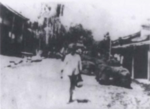
In the World War II, Dehong was a important strategic location of China. Burma Road was built up in 1938, it was an important international channel after Japanese army blockade eastern coast of China, many of strategic materials was imported to China by this road.[37] In 1939, Central Aircraft Manufacturing Company moved to Loiwing in southwest corner or Ruili, it was the biggest aircraft manufacturing plant of China at that time.[38]
After World War II
The area was declared an autonomous region in 1953, and in May 1956 became an autonomous prefecture. In 1960 when interprovincial migration took place many farmers came to Yunnan to farm bananas. This was during the "Great Leap Forward" when a biologist working for Mao Zedong wrote an article about the weather in Yunnan being very suitable for bananas to be planted. A very long time ago before this many Chinese were in fact very scared of going there because of an illness that lurked about. It was later discovered that this was an identifiable tropical disease. The farmers helped to get rid of the disease. They made clearings, roads and space for fields and plantations.
Geography
Dehong stretches 122 km (76 mi) from east to west and 170 km (110 mi) from north to south, its area is 11,526 km2 (4,450 sq mi).
Demographics
The population of Dehong in 2003 was of 1.02 million, 48.17% of whom were Han Chinese, 51.83% were national minorities, mostly Dai and Jingpo.
Climate
| Month | Jan | Feb | Mar | Apr | May | Jun | Jul | Aug | Sep | Oct | Nov | Dec | Year |
|---|---|---|---|---|---|---|---|---|---|---|---|---|---|
| Record high °C (°F) | 27.0 (80.6) |
31.0 (87.8) |
33.4 (92.1) |
35.2 (95.4) |
35.6 (96.1) |
34.9 (94.8) |
34.4 (93.9) |
35.3 (95.5) |
35.0 (95) |
33.4 (92.1) |
29.7 (85.5) |
27.4 (81.3) |
35.6 (96.1) |
| Average high °C (°F) | 22.1 (71.8) |
23.9 (75) |
27.3 (81.1) |
29.5 (85.1) |
29.5 (85.1) |
28.7 (83.7) |
28.0 (82.4) |
29.0 (84.2) |
29.1 (84.4) |
27.8 (82) |
25.0 (77) |
22.4 (72.3) |
26.9 (80.3) |
| Daily mean °C (°F) | 12.6 (54.7) |
14.5 (58.1) |
17.9 (64.2) |
21.1 (70) |
23.3 (73.9) |
24.2 (75.6) |
23.9 (75) |
24.2 (75.6) |
23.5 (74.3) |
21.5 (70.7) |
17.3 (63.1) |
13.7 (56.7) |
19.8 (67.7) |
| Average low °C (°F) | 6.1 (43) |
7.7 (45.9) |
10.7 (51.3) |
14.7 (58.5) |
18.7 (65.7) |
21.4 (70.5) |
21.5 (70.7) |
21.5 (70.7) |
20.4 (68.7) |
17.8 (64) |
12.5 (54.5) |
8.1 (46.6) |
15.1 (59.2) |
| Record low °C (°F) | −0.2 (31.6) |
1.5 (34.7) |
3.6 (38.5) |
7.5 (45.5) |
13.2 (55.8) |
16.8 (62.2) |
15.9 (60.6) |
17.6 (63.7) |
14.5 (58.1) |
9.3 (48.7) |
5.5 (41.9) |
1.0 (33.8) |
−0.2 (31.6) |
| Average precipitation mm (inches) | 13.7 (0.539) |
26.6 (1.047) |
26.9 (1.059) |
65.4 (2.575) |
154.3 (6.075) |
287.5 (11.319) |
360.1 (14.177) |
317.7 (12.508) |
187.0 (7.362) |
137.9 (5.429) |
49.8 (1.961) |
11.8 (0.465) |
1,638.7 (64.516) |
| Average relative humidity (%) | 78 | 72 | 66 | 67 | 75 | 84 | 87 | 86 | 84 | 83 | 82 | 81 | 79 |
| Source: China Meteorological Data Service Center | |||||||||||||
Administration
Dehong is divided into three counties and two county level cities:
| Map | |||||
|---|---|---|---|---|---|
| Name | Hanzi | Hanyu Pinyin | Population (2010) | Area (km²) | Density (/km²) |
| Mangshi City | 芒市 | Máng Shì | 389,891 | 2,987 | 131 |
| Ruili City | 瑞丽市 | Ruìlì Shì | 180,627 | 1,020 | 177 |
| Lianghe County | 梁河县 | Liánghé Xiàn | 154,175 | 1,159 | 133 |
| Yingjiang County | 盈江县 | Yíngjiāng Xiàn | 305,167 | 4,429 | 69 |
| Longchuan County | 陇川县 | Lǒngchuān Xiàn | 181,580 | 1,931 | 94 |
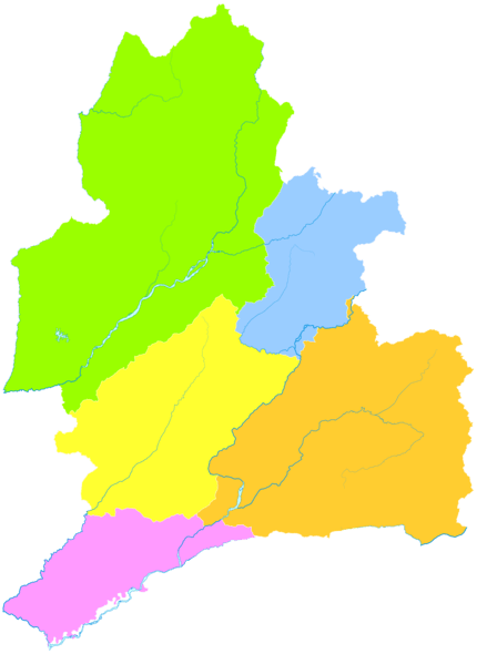
The prefectural government seat is Mangshi.
Economy
Dehong is one of the 3 primary regions for coffee cultivation in Yunnan.[39] The main planter and processor of coffee in Dehong is locally based Hogood Coffee, which operates a contracting scheme with local farmers.[40] Hogood contracts farm land from smallholders on which it plants seedlings, and then re-contracts with farmers to purchase the coffee beans at harvest.[40]
Further reading
- Luo, Yongxian. A Grammar of Dehong, Southwest China. Canberra, ACT: Pacific Linguistics, Research School of Pacific and Asian Studies, Australian National University, 1999. ISBN 0-85883-496-0
Notes
- ↑ The convention in English language named Convention between China and Great Britain giving effect to Article Ⅲ of the Convention of 24 July 1886 relative to Burmah and Thibet, and in Chinese language named 《续议滇缅界、商务条款》
- ↑ The agreement in English language named Agreement between China and Great Britain Modifying the Convention of 1 March 1894 relative to Burmah and Thibet, and in Chinese language named 《续议缅甸条约附款》
References
- ↑ 卫岗 简历 [Curriculum vitae of Wei Gang]. people.com.cn (in Chinese). People's Daily Online, local government leader database. Retrieved 2018-08-16.
- ↑ 王俊强 简历 [Curriculum vitae of Wang Junqiang]. people.com.cn (in Chinese). People's Daily Online, local government leader database. Retrieved 2018-08-16.
- ↑ Li Cheng (李赪) (2012). 《云南统计年鉴2017》 [Statistical Yearbook of Yunnan 2017] (in Chinese). Beijing: China Statistics Press. ISBN 978-7-5037-8267-1.
- 1 2 3 4 5 6 7 8 9 10 11 12 德宏傣族景颇族自治州志编纂委员会 (1994). 《德宏州志·综合卷》 [Annals of Dehong Prefecture · Integrated Volume] (in Chinese). Mangshi: Dehong Nationalities Publishing House. ISBN 7-8052-5248-3.
- 1 2 Luo Jinzhong (罗进忠) (2012). 《云南省2010年人口普查资料》 [People Census Reference of Yunnan 2010] (in Chinese). Beijing: China Statistics Press. ISBN 978-7-5037-6548-3.
- 1 2 3 Executive chief editor: Tian Qiyun (田启云); 德宏傣族景颇族自治州志编纂委员会 (2017). 《德宏年鉴2017》 [Yearbook of Dehong 2017] (in Chinese). Mangshi: Dehong Nationalities Publishing House. ISBN 978-7-5558-0726-1.
- ↑ Niu Ruchen (牛汝辰) (2016). 《中国地名掌故词典》 [Dictionary of etymology of Chinese places name] (in Chinese). Beijing: China Social Publisher. ISBN 978-7-5087-5238-9.
- ↑ Records of the Grand Historian - volume 123, Annals of Dayuan, Wikisource (in Chinese)
- ↑ Lou, Zichang (2006). "论古代滇越并非腾越——兼论滇越国不是傣族先民建立的国家" [The Ancient Dianyue Kingdom neither Tengyue Kingdom nor Found by the Dai People——The Ancient Dianyue Kingdom was not Founded by the Dai People]. Journal of Wenshan Teachers College (in Chinese). 19 (3): 40–44. doi:10.3969/j.issn.1674-9200.2006.03.009.
- ↑ Chronicles of Huayang - volume 4, Annals of Nanzhong, Wikisource (in Chinese)
- 1 2 Lou, Zichang (2007). "古代哀牢国的疆域范围和民族构成再探" [Further Study on the Border and Constitute of Ancient Ailao Country]. Journal of Wenshan Teachers College (in Chinese). 20 (1): 38–43. doi:10.3969/j.issn.1674-9200.2007.01.007.
- ↑ Xiao, Zhengwei (2010). "哀牢国与滇国、滇越国之辨析" [Ailao Country, Dian Country and Dianye Country]. Journal of Baoshan University (in Chinese) (1): 18–23. doi:10.3969/j.issn.1674-9340.2010.01.004.
- ↑ Book of the Later Han - volume 86, Annals of Nanman and Xinanyi, Wikisource (in Chinese)
- 1 2 Shi Weile (史为乐) (2005). 《中国历史地名大辞典》 [Dictionary of Chinese history places name] (in Chinese). Beijing: China Social Science Press. ISBN 7-5004-4929-1.
- 1 2 3 4 5 6 7 8 德宏州政协文史和学习委 (1997). 《德宏州文史资料选辑 第十辑(德宏土司专辑)》 [Compilation of History Reference of Dehong Prefecture - 10th volume (Dehong Tusi volume)] (in Chinese). Mangshi: Dehong Nationalities Publishing House. ISBN 7-80525-340-4.
- ↑ 瑞丽市委宣传部 (2007). 《勐卯弄王国》 [Kingdom of Mong Mao] (in Chinese). Mangshi: Dehong Nationalities Publishing House. ISBN 978-7-80750-070-4.
- ↑ Yang, Yongsheng (1995). ""乘象国滇越"考" [Research of "Dianyue Chengxiang"]. The Ideological Front (in Chinese) (1): 88–91.
- ↑ He, Ping (2007). "傣族历史上并没有一个"达光王国"——与杨永生先生商榷" [There was not a Kingdom of Daguang in the History of the Dai Nationality: A Discussion with Mr. Yang Yongsheng]. Ethno-National Studies (in Chinese) (6): 79–88, 109. doi:10.3969/j.issn.0256-1891.2007.06.011.
- ↑ He, Ping (2005). "傣族历史上并没有一个"果占璧王国"" [There Existed no "Guozhanbi Kingdom" in Dai History]. THINKING (in Chinese). 31 (6): 54–57. doi:10.3969/j.issn.1001-778X.2005.06.011.
- ↑ Duan Yuming (段玉明) (2003). 《大理国史》 [History of Dali Kingdom] (in Chinese). Kunming: Yunnan Nationalities Publishing House. ISBN 7-5367-2480-2.
- ↑ Stephen G. Haw (2006). Marco Polo's China: A Venetian in the Realm of Khubilai Khan. New York: Routledge. ISBN 9-78-0-415-34850-8.
- ↑ Yu Dingbang (余定邦) (2000). 《中缅关系史》 [History of China–Myanmar relations] (in Chinese). Beijing: Guangming Daily Press. ISBN 978-7-8014-5354-9.
- ↑ He, Ping (2004). "德宏傣族的西迁与印度阿洪姆人的形成" [The Westward Immigration of Dai People from Dehong and the Coming-into-Being of the Ahoms in Northeastern India]. Social Sciences In Yunnan (in Chinese) (2): 76–81. doi:10.3969/j.issn.1000-8691.2004.02.019.
- ↑ Gao, Jinhe (2014). "麓川思氏王国的历史兴衰" [The Rise and Fall of Luchuan Kingdom during the Sis' Reign]. Journal of Lincang Teachers' College (in Chinese). 23 (3): 19–23, 35.
- ↑ Lu, Ren (2008). "元代西南边疆与麓川势力兴起的地缘政治" [The Yuan Dynasty's Southwest Frontier and The Geopolitics of the Rise of Luchuan Power]. China's Borderland History and Geography Studies (in Chinese). 18 (3): 55–65, 149.
- ↑ Bi, Aonan (2005). "洪武年间明朝与麓川王国关系考察" [A Review on the Relationship between Ming Dynasty and Luchuan Kingdom in the Hongwu Period]. China's Borderland History and Geography Studies (in Chinese). 15 (2): 102–111, 148–149. doi:10.3969/j.issn.1002-6800.2005.02.012.
- ↑ Li, Zhengting (2008). ""析麓川地"与明代西南边疆变迁关系析评" [The Review of Relation of "Separated the Area of Luchuan" and the Changed of Southwest Borderland of Ming Dynasty]. THINKING (in Chinese). 34 (1): 125–126. doi:10.3969/j.issn.1001-778X.2008.01.028.
- ↑ 云南省瑞丽市志编纂委员会 (1996). 《瑞丽市志》 [Annals of Ruili City] (in Chinese). Chengdu: Sichuan Lexicographical Press. ISBN 7-80543-518-9.
- ↑ 云南省陇川县志编纂委员会 (2005). 《陇川县志》 [Annals of Longchuan County] (in Chinese). Kunming: Yunnan Nationalities Publishing House. ISBN 7-5367-3082-9.
- ↑ 云南省梁河县志编纂委员会 (1993). 《梁河县志》 [Annals of Lianghe County] (in Chinese). Kunming: Yunnan people's Publishing House. ISBN 7-222-01147-1.
- ↑ 盈江县志编纂委员会 (1997). 《盈江县志》 [Annals of Yingjiang County] (in Chinese). Kunming: Yunnan Nationalities Publishing House. ISBN 7-5367-1492-0.
- 1 2 3 云南省潞西县志编纂委员会 (1993). 《潞西县志》 [Annals of Luxi County] (in Chinese). Kunming: Yunnan Education Publishing House. ISBN 7-5415-0685-0.
- ↑ Zhu, Zhaohua (2004). "薛福成与滇缅边界谈判再研究" [A Reappraisal of Xue Fucheng and the Negotiations of the Boundary of China's Yunnan Province and Burma]. CHINA'S BORDERLAND HISTORY AND GEOGRAPHY STUDIES (in Chinese). 14 (1): 43–51. doi:10.3969/j.issn.1002-6800.2004.01.005.
- 1 2 3 Bruce Elleman; Stephen Kotkin; Clive Schofield (2013). Beijing's Power and China's Borders: Twenty Neighbors in Asia. New York: M. E. Sharpe. ISBN 978-0765627643.
- ↑ Wang Tieya (1993). 《中外舊約章彙編》 [Compilation of China-Foreign Countries Former Treaty] (in Chinese). Beijing: SDX Joint Publishing Company.
- ↑ Feng, Yue (2014). "中缅边界问题解决的历史过程(1954-1961)" [Historical Process of Settling the Sino-Myanmar Boundary Issue]. Southeast Asian Affairs (in Chinese) (3): 23–40. doi:10.3969/j.issn.1003-9856.2014.03.004.
- ↑ Jia Guoxiong (贾国雄) (2000). "抗战时期滇缅公路的修建及运输述论" [On Construction and Employment of Yunnan-Burma Road During the Anti-Japanese War]. JOURNAL OF SICHUAN NORMAL UNIVERSITY(SOCIAL SCIENCES EDITION) (in Chinese). 27 (2): 100–105. doi:10.3969/j.issn.1000-5315.2000.02.017.
- ↑ Ma Xiangdong (马向东) (1996). "中央垒允飞机制造厂始末" [The Beginning and End of Central Loiwing Aircraft Manufacturing Company]. THE JOURNAL OF STUDIES OF CHINA’S RESISTANCE WAR AGAINST JAPAN (in Chinese) (2): 95–102.
- 1 2 "China Footprint: Large scale farming leads to high productivity in China". CGTN. September 6, 2017.
External links
| Wikimedia Commons has media related to Dehong Dai and Jingpo Autonomous Prefecture. |
- Dehong local government site (in Chinese)
- Dehong tuanjie bao (magazine in Chinese)
- Dehong (from Xinhuanet.com, in Chinese)