Altay Prefecture
| Altay Prefecture 阿勒泰地区 ئالتاي ۋىلايىتى | |
|---|---|
| Prefecture | |
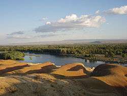 Black Irtysh river in Burqin County | |
 Altay Prefecture (red) in Ili Kazakh Autonomous Prefecture (light red) and Xinjiang (orange) | |
| Coordinates: 47°00′N 88°22′E / 47.000°N 88.367°ECoordinates: 47°00′N 88°22′E / 47.000°N 88.367°E | |
| Country | People's Republic of China |
| Province | Xinjiang |
| Sub-provincial | Ili Prefecture |
| Area | |
| • Prefecture | 117,800 km2 (45,500 sq mi) |
| • Urban | 10,852 km2 (4,190 sq mi) |
| • Metro | 10,852 km2 (4,190 sq mi) |
| Population (2010 census) | |
| • Prefecture | 603,280 |
| • Density | 5.1/km2 (13/sq mi) |
| • Urban | 216,890 |
| • Urban density | 20/km2 (52/sq mi) |
| • Metro | 216,890 |
| • Metro density | 20/km2 (52/sq mi) |
| Time zone | UTC+8 (China Standard) |
| ISO 3166 code | CN-XJ-43 |
| Website | Altay Prefecture Government |
| Altay Prefecture | |||||||||||
| Chinese name | |||||||||||
|---|---|---|---|---|---|---|---|---|---|---|---|
| Simplified Chinese | 阿勒泰地区 | ||||||||||
| Traditional Chinese | 阿勒泰地區 | ||||||||||
| Hanyu Pinyin | Ālètài Dìqū | ||||||||||
| |||||||||||
| Uyghur name | |||||||||||
| Uyghur |
ئالتاي ۋىلايىتى | ||||||||||
| |||||||||||
| Kazakh name | |||||||||||
| Kazakh |
التاي ايماعى Altai' Ai'mag'y | ||||||||||
Altay Prefecture is located in northern Xinjiang, People's Republic of China. It has an area of 118,015 km2 (45,566 sq mi) and a population of 561,667 (2000). It is a part of Ili Kazakh Autonomous Prefecture. At the 2000 census, Altay was the only major subdivision of Ili Kazakh Autonomous Prefecture with an ethnic Kazakh majority (about 51%). In 2007 it had a GDP of RMB 9.9 billion with a 12% growth rate. It is also shares international border with the neighboring Altai Republic, Russia.
Subdivisions
The prefecture is divided into 1 county-level city and 6 counties.
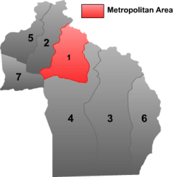 | ||||||||||
| # | Name | Hanzi | Hanyu Pinyin | Uyghur (UEY) | Uyghur Latin (ULY) | Kazakh (Arabic script) | Kazakh Latin alphabet | Population (2010 Census) | Area (km²) | Density (/km²) |
|---|---|---|---|---|---|---|---|---|---|---|
| 1 | Altay | 阿勒泰市 | Ālètài Shì | ئالتاي شەھىرى | Altay Shehiri | التاي قالاسى | Altaı qalasy | 190,064 | 10,852 | 17.51 |
| 2 | Burqin County | 布尔津县 | Bù'ěrjīn Xiàn | بۇرچىن ناھىيىسى | Burchin Nahiyisi | بۋىرشىن اۋدانى | Býyrshyn aýdany | 66,758 | 10,369 | 6.43 |
| 3 | Fuyun County[1] | 富蕴县 | Fùyùn Xiàn | كوكتوقاي ناھىيىسى | Koktoqay Nahiyisi | كوكتوعاي اۋدانى | Kóktoǵaı aýdany | 87,886 | 32,327 | 2.71 |
| 4 | Fuhai County[1] | 福海县 | Fúhǎi Xiàn | بۇرۇلتوقاي ناھىيىسى | Burultoqay Nahiyisi | بۋرىلتوعاي اۋدانى | Buryltoǵaı aýdany | 81,845 | 33,319 | 2.45 |
| 5 | Habahe County[1] | 哈巴河县 | Hābāhé Xiàn | قابا ناھىيىسى | Qaba Nahiyisi | قابا اۋدانى | Qaba aýdany | 82,507 | 8,186 | 10.07 |
| 6 | Qinghe County[1] | 青河县 | Qīnghé Xiàn | چىڭگىل ناھىيىسى | Chinggil Nahiyisi | شىڭگىل اۋدانى | Shińgil aýdany | 58,858 | 15,790 | 3.72 |
| 7 | Jeminay County | 吉木乃县 | Jímùnǎi Xiàn | جېمىنەي ناھىيىسى | Jëminey Nahiyisi | جەمەنەي اۋدانى | Jemeneı aýdany | 35,365 | 7,145 | 4.94 |
References
This article is issued from
Wikipedia.
The text is licensed under Creative Commons - Attribution - Sharealike.
Additional terms may apply for the media files.