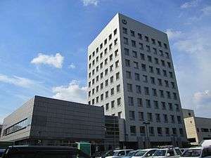
Hachinohe, Aomori
| Hachinohe 八戸市 | |||
|---|---|---|---|
| Core city | |||
 Sky line of HachinoheCity | |||
| |||
 Location of Hachinohe in Aomori Prefecture | |||
 Hachinohe | |||
| Coordinates: 40°30′44.2″N 141°29′18.2″E / 40.512278°N 141.488389°ECoordinates: 40°30′44.2″N 141°29′18.2″E / 40.512278°N 141.488389°E | |||
| Country | Japan | ||
| Region | Tōhoku | ||
| Prefecture | Aomori Prefecture | ||
| Government | |||
| • Mayor | Makoto Kobayashi | ||
| Area | |||
| • Total | 305.54 km2 (117.97 sq mi) | ||
| Population (February 28, 2017) | |||
| • Total | 234,033 | ||
| • Density | 756/km2 (1,960/sq mi) | ||
| Time zone | UTC+9 (Japan Standard Time) | ||
| City symbols | |||
| - Tree | Japanese yew | ||
| - Flower | Chrysanthemum | ||
| - Bird | Black-tailed gull | ||
| Phone number | 0178-43-2111 | ||
| Address | 1-1-1 Uchimaru, Hachinohe-shi, Aomori-ken 031-8686 | ||
| Website |
www | ||


Hachinohe (八戸市 Hachinohe-shi) is a city located in Aomori Prefecture, Japan.
As of 28 February 2017, the city had an estimated population of 229,527, and a population density of 756 persons per km2 in 107,598 households.[1] This makes it the second biggest city of Aomori prefecture. The total area is 305.54 square kilometres (117.97 sq mi).
History
The area around Hachinohe has been occupied since prehistoric times, and was a major population center for the Emishi people. Numerous Jōmon period remains have been discovered within the borders of Hachinohe. The area was nominally under control of the Northern Fujiwara in the Heian period, and became part of the holdings granted to the Nanbu clan after the defeat of the North Fujiwara by Minamoto no Yoritomo in the Kamakura period. The Nanbu established numerous horse ranches, accompanied by numbered fortified settlements. During the Edo period, it was initially part of Morioka Domain, but in 1664 the Tokugawa shogunate authorized the creation of a separate 20,000 koku Hachinohe Domain for a junior line of the Nanbu clan. The town prospered as a castle town centered on Hachinohe Castle, and served as a small commercial centre and port for the fishing grounds off southeastern Hokkaido. Today, the port still serves the fishing industry and a number of international cargo vessels.
After the Meiji Restoration, Hachinohe Domain was abolished, and replaced by Hachinohe Prefecture, which was subsequently merged into Aomori Prefecture. Initially, there was a debate as to whether the capital of newly formed Aomori Prefecture should be at Hachinohe or Hirosaki; however, due to strong rivalry between the former Nanbu domain and former Tsugaru Domain, the Meiji government decided to build a new town called Aomori in a central location, and to designate it as the capital of the prefecture.
Per the establishment of the Meiji period municipalities system on April 1, 1889, the town of Hachinohe was created within Sannohe District. In 1901, it merged with neighboring Chōja, and on May 1, 1929, with neighboring Konakano, Minato and Same villages to form the city of Hachinohe. The city further expanded by annexing the village of Shimonaganawashiro in 1942, Korekawa in 1954, Ichikawa, Kaminaganawashiro, Tachi and Toyosaki in 1955 and Odate in 1958.
On March 31, 2005, the village of Nangō (from Sannohe District) was also merged into Hachinohe.
During the American occupation of Japan following World War II, a United States Army base, Camp Haugen, was located in Hachinohe, and was the home of the Seventh Division. An Armed Forces Radio Service radio station was located on the base; it was known as AFRS Hachinohe. In 1950, after the North Korean invasion of South Korea, troops from Camp Haugen left for Korea. AFRS Hachinohe altered its broadcasts to include coverage of South Korea so Americans could benefit from its news and entertainment programs. With the final withdrawal of American forces from Hachinohe in 1956, the base was turned over to the Japan Ground Self-Defense Force and was officially re-designated JGSDF Camp Hachinohe.[2]
In March 2011, the city was one of those hit by the 2011 Japanese tsunami. The tsunami tossed many huge fishing boats ashore and heavily damaged the port area. About 100 homes were destroyed.[3] Divers from the United States Navy ship Safeguard joined with Japanese workers to help clear the port to facilitate the delivery of relief supplies via the city.[4]
On January 1, 2017, Hachinohe was given core city status.[5]
Geography
Hachinohe is located in the flatlands on the southeast coast of Aomori Prefecture, facing the Pacific Ocean. Both the Oirase River and the Mabechi River flow through Hachinohe. A portion of the coastal areas of the city were within the borders of the Tanesashi Kaigan Hashikamidake Prefectural Natural Park, which was incorporated into the Sanriku Fukkō National Park in 2013.[6][7]
Climate
Hachinohe has a climate on the southern periphery of the humid continental climate (Köppen Dfa) that borders on both an oceanic climate (Köppen Cfb) and humid subtropical climate (Köppen Cfa). Summers are considerably milder than in other parts of Honshu because the city is very close to the open sea, whilst winters if distinctly cold are much less snowy than in Aomori city or Sapporo or Wakkanai, although snowfall is higher than in Kushiro.The average annual temperature in Hachinohe is 9.9 °C. The average annual rainfall is 1165 mm with September as the wettest month.The temperatures are highest on average in August, at around 22.7 °C, and lowest in January, at around -1.9 °C.[8]
| Climate data for Hachinohe (1981–2010) | |||||||||||||
|---|---|---|---|---|---|---|---|---|---|---|---|---|---|
| Month | Jan | Feb | Mar | Apr | May | Jun | Jul | Aug | Sep | Oct | Nov | Dec | Year |
| Average high °C (°F) | 2.6 (36.7) |
3.2 (37.8) |
7.0 (44.6) |
13.7 (56.7) |
18.3 (64.9) |
20.6 (69.1) |
24.3 (75.7) |
26.5 (79.7) |
23.1 (73.6) |
17.9 (64.2) |
11.6 (52.9) |
5.5 (41.9) |
14.5 (58.1) |
| Daily mean °C (°F) | −0.9 (30.4) |
−0.5 (31.1) |
2.7 (36.9) |
8.5 (47.3) |
13.1 (55.6) |
16.2 (61.2) |
20.1 (68.2) |
22.5 (72.5) |
18.9 (66) |
13.0 (55.4) |
6.9 (44.4) |
1.8 (35.2) |
10.2 (50.4) |
| Average low °C (°F) | −4.2 (24.4) |
−4 (25) |
−1.3 (29.7) |
3.8 (38.8) |
8.7 (47.7) |
12.8 (55) |
17.1 (62.8) |
19.3 (66.7) |
15.2 (59.4) |
8.5 (47.3) |
2.6 (36.7) |
−1.6 (29.1) |
6.4 (43.5) |
| Average precipitation mm (inches) | 42.8 (1.685) |
40.1 (1.579) |
52.0 (2.047) |
64.3 (2.531) |
89.3 (3.516) |
105.8 (4.165) |
136.1 (5.358) |
128.8 (5.071) |
167.6 (6.598) |
87.2 (3.433) |
62.0 (2.441) |
49.1 (1.933) |
1,025.1 (40.357) |
| Average snowfall cm (inches) | 77 (30.3) |
75 (29.5) |
47 (18.5) |
3 (1.2) |
0 (0) |
0 (0) |
0 (0) |
0 (0) |
0 (0) |
0 (0) |
6 (2.4) |
40 (15.7) |
248 (97.6) |
| Average relative humidity (%) | 70 | 70 | 67 | 65 | 71 | 81 | 83 | 82 | 79 | 73 | 70 | 70 | 73 |
| Mean monthly sunshine hours | 130.8 | 129.6 | 168.1 | 188.9 | 197.0 | 167.7 | 148.5 | 167.1 | 143.6 | 161.3 | 133.3 | 124.5 | 1,860.4 |
| Source: Japan Meteorological Agency | |||||||||||||
Neighbouring municipalities
Aomori Prefecture
Demographics
Per Japanese census data:[9]
| Census Year | Population |
|---|---|
| 1970 | 216,955 |
| 1980 | 245,617 |
| 1990 | 247,983 |
| 2000 | 248,608 |
| 2010 | 237,473 |
Government
Hachinohe has a mayor-council form of government with a directly elected mayor and a unicameral city legislature of 32 members.
Economy
Hachinohe is the largest city in eastern Aomori Prefecture, and serves as the regional industrial and commercial center. Commercial fishing still plays a major role in the local economy, with Hachinohe port having one of the largest volumes of landed fish in Japan. However, since its designation as a new industrial city in 1964, Hachinohe has developed a large coastal industrial belt with a diverse range of chemical, steel, cement and fertilizer products. Major industrial parks include the Hachinohe High Tech Park and Hachinohe North-Interchange Industrial Complex. Hachinohe Port is a major international port for northern Japan.
Education
Colleges and universities
Primary and secondary education
Hachinohe has 43 public elementary schools and 24 public junior high schools operated by the city government, and one private middle school. The city has eight public high schools operated by the Aomori Prefectural Board of Education, and one public high school operated by the national government. There are also eight private high schools. The city also has three special education schools.[10]
Transportation
Railway
- East Japan Railway Company - Tōhoku Shinkansen
- East Japan Railway Company - Hachinohe Line
- Hachinohe - Naganawashiro - Hon-Hachinohe - Konakano, Mutsu-Minato - Shirogane - Same - Mutsu-Shirahama - Tanesashi-Kaigan - Ōkuki - Kanehama
- Aoimori Railway - Aoimori Railway Line
- Hachinohe Rinkai Railway (freight only)
Highway
Seaports
Local attractions
Traditional handicrafts
- Yawata-uma, a wooden horse with gold saddle markings and a decorative plume attached to its head. The Hachinohe area has been known since the Kamakura period for its breed of war horses. Also, farming horses have supported the lives of the commoners and have often been used as the theme for dances and folk tales. The art of Yawata-uma figurines is a regional art form and popular souvenir.
Local sights
- Kabushima is an island offshore Hachinohe which also serves as a habitat for forty thousand black-tailed gulls, or umineko. It is a national Natural Monument.[11] It also has a shinto shrine.
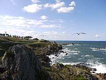
- Tanesashi Coast a nationally designated Place of Scenic Beauty.[12][13]
- Yomasari Dam
Local festivals
- Emburi is a citywide festival which is also celebrated in nearby towns. The object of the festival is to pray for a bountiful harvest in the coming year. It originated as a dance with an agricultural tool (the eburi; enburi is a local pronunciation), which was used to teach people how to cultivate the land. Nowadays it is a parade of 15-20 people, with 3-5 dancers and a singer accompanied by wooden flutes, drums and bells. The festival takes place February 17–20, and marks the official end of the long, harsh winter.
- Hachinohe Sansha Taisai is another citywide festival and is considered to be the main festival of the town. It is also billed as "Japan's Biggest Float Festival". Sansha means "three shrines" and Taisai means "festival": It is held by three Shinto shrines: Ogami Jinja, Shinra Jinja, and Shinmei-gu. Floats proceed through the main streets of the city, accompanied by people with drums, flutes and loud calls. 27 different floats are used, and they are proudly constructed and flourished by the members of various organizations, such as schools and the city hall. The floats are also accompanied by men in samurai costumes on horseback, and tiger dancers. On the second and third days of the festival, a traditional game of a sport similar to polo is held at the stables of Shinra Shrine. This sport (加賀美流騎馬打毬 Kaga Biryū Kiba Dakyū) is officially an "intangible cultural asset" of Aomori Prefecture. Sansha Taisai takes place from July 31 to August 4 every year.
National Historic Sites
- Chōshichiyachi Shell Mound, Jōmon period ruins
- Korekawa Site, Jōmon period ruins
- Tangotai Kofun cluster, Kofun period tumuli
- Ne Castle, Muromachi period castle ruins
Other
- The sound of the umi-neko at Hachinohe was selected by the Ministry of the Environment as one of the 100 Soundscapes of Japan.[14]
Sports
- Vanraure Hachinohe, J-League soccer team
- Tohoku Free Blades, Asia League Ice Hockey team
Sister city relations


Notable people from Hachinohe
- Saeko Chiba, voice actress
- Miki Furukawa, musician
- Kengo Hanazawa, manga artist
- Chiharu Icho, freestyle wrestler
- Kaori Icho, freestyle wrestler
- Masako Katsuki, voice actress
- Hitomi Obara, freestyle wrestler
- Tadamori Oshima, politician
- Marimo Ragawa, manga artist
Other
References
- ↑ Official home page
- ↑ Col. Orin D. Haugen, Regimental Commander (History of the 511th Airborne Regiment)
- ↑ Flack, T. D., "Misawa residents pull clean-up duty at nearby fishing port", Stars and Stripes, 17 March 2011, retrieved 18 March 2011.
- ↑ Johnson, Christopher, "U.S. Helps Clear Vital Japan Harbor", Washington Times, 27 March 2011, retrieved 30 March 2011.
- ↑ Ministry of Internal Affairs and Communications of Japan, official home page(in Japanese)
- ↑ 基礎情報 [Basic Information] (in Japanese). Ministry of the Environment. Retrieved 22 October 2013.
- ↑ "National park of restoration". The Japan Times. 28 May 2013. Retrieved 22 October 2013.
- ↑ Hachinohe climate data
- ↑ Hachinohe population statistics
- ↑ 八戸市学校一覧 City of Hachinohe official home page
- ↑ [http://kunishitei.bunka.go.jp/bsys/maindetails.asp?register_id=401&item_id=89 蕪島ウミネコ繁殖地 - Agency for Cultural Affairs database (in Japanese)
- ↑ "種差海岸". Agency for Cultural Affairs. Retrieved 10 February 2012.
- ↑ "Tanesashi Kaigan". Hachinohe City. Retrieved 10 February 2012.
- ↑ (PDF). Ministry of the Environment http://www.env.go.jp/air/life/nihon_no_oto/02_2007oto100sen_Pamphlet.pdf. Retrieved 18 March 2017. Missing or empty
|title=(help) - ↑ "US-Japan Sister Cities by State". Asia Matters for America. Honolulu, HI: East-West Center. Retrieved 20 November 2015.
- ↑ "Hachinohe City official home page". Sister City: Lanzhou, Gansu, China. Retrieved 21 November 2015.
External links
| Wikimedia Commons has media related to Hachinohe, Aomori. |
| Wikivoyage has a travel guide for Hachinohe. |
- Official Website (in Japanese)