Oirase River
| Oirase River | |
|---|---|
 Oirase River gorge | |
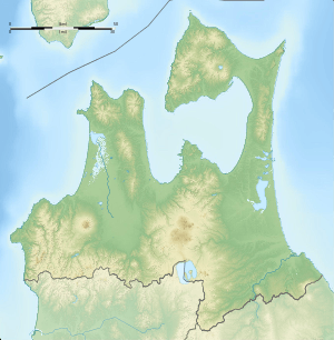 Location of the mouth in Japan  Oirase River (Japan) | |
| Native name | 奥入瀬川 |
| Physical characteristics | |
| Main source |
Lake Towada Aomori & Akita Prefectures, Japan 401 m (1,316 ft) 40°28′N 140°52′E / 40.467°N 140.867°E |
| River mouth |
Hachinohe Pacific Ocean 0 m (0 ft) 40°36′28″N 141°27′40″E / 40.60778°N 141.46111°ECoordinates: 40°36′28″N 141°27′40″E / 40.60778°N 141.46111°E |
| Length | 67 km (42 mi) |
| Basin features | |
| Basin size | 820 km2 (320 sq mi) |
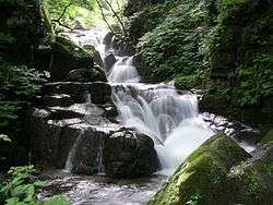
The Oirase River (奥入瀬川 Oirase-gawa) is a river located in eastern Aomori prefecture, in the Tōhoku region of northern Japan. The Oirase River is the only river draining Lake Towada, a large caldera lake on the border of Aomori and Akita Prefectures. The river flows in a generally eastern direction, through the municipalities of Towada, Rokunohe, Oirase and Hachinohe before exiting into the Pacific Ocean. The upper reaches of the river form a scenic gorge with numerous rapids and waterfalls, and is one of the major tourist attractions of the Towada-Hachimantai National Park. The lower reaches of the river are used extensively for irrigation.
In 1996 the sound of flowing water at the Oirase River was selected by the Ministry of the Environment as one of the 100 Soundscapes of Japan.[1]
Gallery
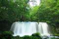 Chōshi Falls
 Kumoi Falls
 Rock cave at Oirase River
.jpg) Oirase River
Oirase River
References
- Campbell, Allen; Nobel, David S (1993). Japan: An Illustrated Encyclopedia. Kodansha. p. 1134. ISBN 406205938X.
External links
| Wikimedia Commons has media related to Oirase River. |
Notes
- ↑ "残したい"日本の音風景100選"パンフレット" (PDF). Ministry of the Environment. Retrieved 18 February 2017.
| |||||||||||||||||
| |||||||||||||||||
| |||||||||||||||||
| |||||||||||||||||
| |||||||||||||||||