Dickinson, Franklin County, New York
| Dickinson, Franklin County, New York | |
|---|---|
| Town | |
 Dickinson Location within the state of New York | |
| Coordinates: 44°43′54″N 74°32′5″W / 44.73167°N 74.53472°W | |
| Country | United States |
| State | New York |
| County | Franklin |
| Government | |
| • Type | Town Council |
| • Town Supervisor | Joseph M. Clookey (R) |
| • Town Council |
Members' List
|
| Area[1] | |
| • Total | 44.31 sq mi (114.77 km2) |
| • Land | 44.22 sq mi (114.54 km2) |
| • Water | 0.09 sq mi (0.23 km2) |
| Elevation | 928 ft (283 m) |
| Population (2010) | |
| • Total | 823 |
| • Estimate (2016)[2] | 799 |
| • Density | 18.07/sq mi (6.98/km2) |
| Time zone | UTC-5 (Eastern (EST)) |
| • Summer (DST) | UTC-4 (EDT) |
| FIPS code | 36-20610 |
| GNIS feature ID | 0978904 |
Dickinson is a town in Franklin County, New York, United States. The population was 823 at the 2010 census.[3] The town was named after an individual in New Jersey by an early landowner from that state.
Dickinson is on the western border of Franklin County, southwest of Malone and east of Potsdam.
History
The name originally proposed for the area was "Annastown", after the daughter of a landowner, but another influential landowner prevailed with the current name.
The town of Dickinson was formed from the town of Malone in 1809. In 1812, part of Dickinson was used to form the town of Bangor. The creation of the town of Moira in 1828 cost Dickinson more territory. When the town of Waverly was established in 1880, additional territory was lost.
In 1843, conversions to the Mormon religion and migration westward occurred in the town due to relatives of a Mormon apostle living there.
Geography
According to the United States Census Bureau, the town has a total area of 44.3 square miles (114.8 km2), of which 44.2 square miles (114.5 km2) is land and 0.1 square miles (0.2 km2), or 0.20%, is water.[3]
The west town line is the border of St. Lawrence County. The town is located along the northern edge of the Adirondacks.
New York State Route 11B is an east-west highway.
Demographics
| Historical population | |||
|---|---|---|---|
| Census | Pop. | %± | |
| 1820 | 495 | — | |
| 1830 | 446 | −9.9% | |
| 1840 | 1,005 | 125.3% | |
| 1850 | 1,119 | 11.3% | |
| 1860 | 1,917 | 71.3% | |
| 1870 | 1,990 | 3.8% | |
| 1880 | 2,329 | 17.0% | |
| 1890 | 1,664 | −28.6% | |
| 1900 | 1,691 | 1.6% | |
| 1910 | 1,609 | −4.8% | |
| 1920 | 1,312 | −18.5% | |
| 1930 | 1,061 | −19.1% | |
| 1940 | 934 | −12.0% | |
| 1950 | 834 | −10.7% | |
| 1960 | 857 | 2.8% | |
| 1970 | 832 | −2.9% | |
| 1980 | 786 | −5.5% | |
| 1990 | 751 | −4.5% | |
| 2000 | 739 | −1.6% | |
| 2010 | 823 | 11.4% | |
| Est. 2016 | 799 | [2] | −2.9% |
| U.S. Decennial Census[4] | |||
As of the census[5] of 2000, there were 739 people, 293 households, and 217 families residing in the town. The population density was 16.7 people per square mile (6.4/km²). There were 424 housing units at an average density of 9.6 per square mile (3.7/km²). The racial makeup of the town was 97.56% White, 0.41% African American, 1.22% Native American, 0.14% Asian, and 0.68% from two or more races. Hispanic or Latino of any race were 0.41% of the population.
There were 293 households out of which 29.7% had children under the age of 18 living with them, 57.7% were married couples living together, 8.9% had a female householder with no husband present, and 25.9% were non-families. 20.1% of all households were made up of individuals and 8.2% had someone living alone who was 65 years of age or older. The average household size was 2.52 and the average family size was 2.88.
In the town, the population was spread out with 24.6% under the age of 18, 6.5% from 18 to 24, 27.3% from 25 to 44, 26.4% from 45 to 64, and 15.2% who were 65 years of age or older. The median age was 39 years. For every 100 females, there were 107.0 males. For every 100 females age 18 and over, there were 101.8 males.
The median income for a household in the town was $31,711, and the median income for a family was $34,875. Males had a median income of $27,083 versus $22,039 for females. The per capita income for the town was $15,701. About 11.2% of families and 16.5% of the population were below the poverty line, including 30.1% of those under age 18 and 15.4% of those age 65 or over.
Communities and locations in Dickinson
- Alburg – A hamlet on the north town line, west of Irish Corners.
- Deer River – A stream flowing out the west town line.
- Dickinson – A hamlet on NY-11B at the junction of County Road 5. It was formerly called Harwoods Corners.
- Dickinson Center – A hamlet south of Dickinson on County Road 5. Located near Dickinson Center is the Hastings Farmstead, listed on the National Register of Historic Places in 2007.[6]
- East Dickinson – A hamlet in the northeast corner of the town on NY-11B.
- Irish Corners – A hamlet on the north town line.
Notable people
References
- ↑ "2016 U.S. Gazetteer Files". United States Census Bureau. Retrieved Jul 5, 2017.
- 1 2 "Population and Housing Unit Estimates". Retrieved June 9, 2017.
- 1 2 "Geographic Identifiers: 2010 Census Summary File 1 (G001), Dickinson town, Franklin County, New York". American FactFinder. U.S. Census Bureau. Retrieved June 13, 2016.
- ↑ "Census of Population and Housing". Census.gov. Archived from the original on May 12, 2015. Retrieved June 4, 2015.
- ↑ "American FactFinder". United States Census Bureau. Archived from the original on 2013-09-11. Retrieved 2008-01-31.
- ↑ National Park Service (2009-03-13). "National Register Information System". National Register of Historic Places. National Park Service.
External links
Coordinates: 44°44′54″N 74°33′53″W / 44.74833°N 74.56472°W
Municipalities and communities of Franklin County, New York, United States | ||
|---|---|---|
| Towns | 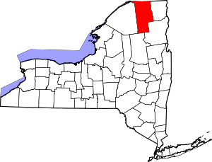 | |
| Villages | ||
| CDPs | ||
| Hamlets | ||
| Indian reservation | ||
| Footnotes | ‡This populated place also has portions in an adjacent county or counties | |