Elizabeth, Colorado
| Elizabeth, Colorado | |
|---|---|
| Statutory Town | |
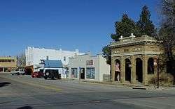 Old Town Elizabeth, Colorado | |
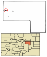 Location of Elizabeth in Elbert County, Colorado. | |
| Coordinates: 39°21′40″N 104°36′22″W / 39.361015°N 104.606172°WCoordinates: 39°21′40″N 104°36′22″W / 39.361015°N 104.606172°W[1] | |
| Country |
|
| State |
|
| County | Elbert County[2] |
| Incorporated | October 9, 1890[3] |
| Government | |
| • Type | Statutory Town[2] |
| Area[4] | |
| • Total | 1.25 sq mi (3.23 km2) |
| • Land | 1.25 sq mi (3.23 km2) |
| • Water | 0.00 sq mi (0.00 km2) |
| Elevation[5] | 6,476 ft (1,974 m) |
| Population (2010) | |
| • Total | 1,358 |
| • Estimate (2016)[6] | 1,394 |
| • Density | 1,116.09/sq mi (430.94/km2) |
| Time zone | UTC-7 (MST) |
| • Summer (DST) | UTC-6 (MDT) |
| ZIP code[7] | 80107 |
| Area code(s) | 303 |
| INCITS place code | 0823740 |
| GNIS feature ID | 0185149 |
| FIPS code | 08-23740 |
| Website |
www |
Elizabeth is a statutory town which is the most populous municipality in Elbert County, Colorado, United States. The population was 1,358 at the 2010 census,[8] down from 1,434 at the 2000 census.
History
Elizabeth, initially called Russellville, was originally a saw mill camp.[9] The town was later named after a family member of John Evans, a territorial governor.[10]
The Town was incorporated in October 1890 and has had a post office since 1882.[11] The 2010 estimated population was 1,358.[8]
Geography
Elizabeth is located in western Elbert County at 39°21′36″N 104°36′0″W / 39.36000°N 104.60000°W (39.359954, -104.600063).[12] Colorado State Highway 86 passes through the town, leading east 7 miles (11 km) to Kiowa and west 15 miles (24 km) to Castle Rock. Denver is 40 miles (64 km) to the northwest via Franktown and Parker.
According to the United States Census Bureau, the town has a total area of 1.2 square miles (3.2 km2), all of it land.[8]
Demographics
| Historical population | |||
|---|---|---|---|
| Census | Pop. | %± | |
| 1900 | 215 | — | |
| 1910 | 194 | −9.8% | |
| 1920 | 230 | 18.6% | |
| 1930 | 266 | 15.7% | |
| 1940 | 275 | 3.4% | |
| 1950 | 263 | −4.4% | |
| 1960 | 326 | 24.0% | |
| 1970 | 493 | 51.2% | |
| 1980 | 789 | 60.0% | |
| 1990 | 818 | 3.7% | |
| 2000 | 1,434 | 75.3% | |
| 2010 | 1,358 | −5.3% | |
| Est. 2016 | 1,394 | [6] | 2.7% |
| U.S. Decennial Census[13] | |||
As of the census[14] of 2000, there were 1,434 people, 496 households, and 380 families residing in the town. The population density was 1,670.6 people per square mile (643.8/km²). There were 513 housing units at an average density of 597.6 per square mile (230.3/km²). The racial makeup of the town was 94.00% White, 0.07% African American, 0.84% Native American, 0.21% Asian, 3.49% from other races, and 1.39% from two or more races. Hispanic or Latino of any race were 6.00% of the population.
There were 496 households out of which 47.2% had children under the age of 18 living with them, 60.3% were married couples living together, 11.7% had a female householder with no husband present, and 23.2% were non-families. 16.9% of all households were made up of individuals and 4.0% had someone living alone who was 65 years of age or older. The average household size was 2.89 and the average family size was 3.27.
In the town, the population was spread out with 33.3% under the age of 18, 9.7% from 18 to 24, 36.5% from 25 to 44, 16.4% from 45 to 64, and 4.2% who were 65 years of age or older. The median age was 30 years. For every 100 females, there were 105.4 males. For every 100 females age 18 and over, there were 99.8 males.
The median income for a household in the town was $49,596, and the median income for a family was $51,902. Males had a median income of $38,875 versus $25,066 for females. The per capita income for the town was $18,902. About 7.8% of families and 9.2% of the population were below the poverty line, including 11.8% of those under age 18 and 9.5% of those age 65 or over.
Media
Elizabeth is home to the weekly newspaper, the Meadowlark Herald,[15] which is also the only newspaper wholly owned and published in Elbert County. The Elbert County News, The Ranchland News, The West Elbert County Sun, and The Prairie Times also publish Elbert County news and distribute widely in the county.
References
- ↑ "2014 U.S. Gazetteer Files: Places". United States Census Bureau. July 1, 2014. Retrieved January 6, 2015.
- 1 2 "Active Colorado Municipalities". State of Colorado, Department of Local Affairs. Archived from the original on 2010-11-23. Retrieved 2007-09-01.
- ↑ "Colorado Municipal Incorporations". State of Colorado, Department of Personnel & Administration, Colorado State Archives. 2004-12-01. Retrieved 2007-09-02.
- ↑ "2016 U.S. Gazetteer Files". United States Census Bureau. Retrieved Jul 25, 2017.
- ↑ "US Board on Geographic Names". United States Geological Survey. 2007-10-25. Retrieved 2008-01-31.
- 1 2 "Population and Housing Unit Estimates". Retrieved June 9, 2017.
- ↑ "ZIP Code Lookup". United States Postal Service. Archived from the original (JavaScript/HTML) on January 1, 2008. Retrieved September 9, 2007.
- 1 2 3 "Geographic Identifiers: 2010 Demographic Profile Data (G001): Elizabeth town, Colorado". American Factfinder. U.S. Census Bureau. Retrieved January 25, 2016.
- ↑ "History". Town of Elizabeth. Retrieved 2018-06-27.
- ↑ Dawson, John Frank. Place names in Colorado: why 700 communities were so named, 150 of Spanish or Indian origin. Denver, CO: The J. Frank Dawson Publishing Co. p. 20.
- ↑ "Post offices". Jim Forte Postal History. Archived from the original on 6 March 2016. Retrieved 25 June 2016.
- ↑ "US Gazetteer files: 2010, 2000, and 1990". United States Census Bureau. 2011-02-12. Retrieved 2011-04-23.
- ↑ "Census of Population and Housing". Census.gov. Archived from the original on May 12, 2015. Retrieved June 4, 2015.
- ↑ "American FactFinder". United States Census Bureau. Archived from the original on 2013-09-11. Retrieved 2008-01-31.
- ↑ http://www.meadowlarkherald.blogspot.com
External links
Municipalities and communities of Elbert County, Colorado, United States | ||
|---|---|---|
| Towns | 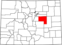 | |
| CDP | ||
| Unincorporated communities | ||
