Istočno Sarajevo
| Istočno Sarajevo Источно Сарајево East Sarajevo | |||
|---|---|---|---|
| City | |||
   | |||
| |||
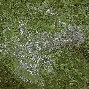
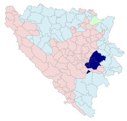 Location of Istočno Sarajevo within Bosnia and Herzegovina | |||
| Coordinates: 43°49′N 18°21′E / 43.817°N 18.350°ECoordinates: 43°49′N 18°21′E / 43.817°N 18.350°E | |||
| Country | Bosnia and Herzegovina | ||
| Entity | Republika Srpska | ||
| Area | |||
| • City | 1,450 km2 (560 sq mi) | ||
| Population (2013) | |||
| • City | 61,516 | ||
| • Density | 42,4/km2 (1,100/sq mi) | ||
| • Urban | 43,567 | ||
| Time zone | UTC+1 (CET) | ||
| • Summer (DST) | UTC+2 (CEST) | ||
| Area code(s) | (387) 57 | ||
| Website |
www | ||
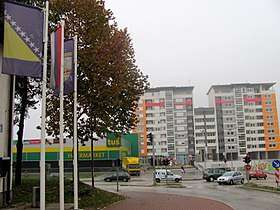
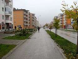
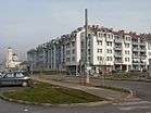
Istočno Sarajevo (Serbian Cyrillic: Источно Сарајево, "East Sarajevo") or East Sarajevo, is a city located in Republika Srpska (RS), an entity of Bosnia and Herzegovina. It consists of a few pre-war suburban parts of Sarajevo which are now in the Republika Srpska entity (east of Sarajevo), and newly built areas. As of 2013, it has a population of 61,516 inhabitants.
It was previously known as Srpsko Sarajevo (Српско Сарајево, "Serb Sarajevo") but the Constitutional Court of Bosnia and Herzegovina adjudicated its name change. With an area of 1450 km2, it is one of the largest municipalities in the Balkans.
History
The first civilian government in the territory of East Sarajevo was formed at the parliamentary session in the building of the local community Lukavica late summer of 1992. year. The commission organized by the Serbian municipality of Novo Sarajevo, headed by a Commissioner of the Presidency of the Republic of Srpska dr Dragan Đokanović, was held the Municipal Assembly of Srpsko Novo Sarajevo, consisting of the members of Serbian nationality, pre-war Sarajevo municipality of Novo Sarajevo. Invited members, elected in multiparty elections 1990th, elected municipal government.[1][2]
Geography and climate
Geography
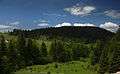
East Sarajevo lies in the Sarajevo valley, in the middle of the Dinaric Alps. The city is surrounded by heavily forested hills and five major mountains. The highest of the surrounding peaks is Treskavica at 2,088 meters (6,850 ft), then Bjelašnica at 2,067 meters (6,781 ft), Jahorina at 1,913 meters (6,276 ft), Trebević at 1,627 meters (5,338 ft), with 1,502 meters (4,928 ft) Igman being the shortest. Last four are also known as Olympics mountains of Sarajevo (see also 1984 Winter Olympic Games in Sarajevo).
The Željeznica river is one of the city's chief geographic features. It flows through the city from south through the Trnovo, Kijevo, Krupac and Vojkovići, parts of East Sarajevo to west part of city and Sarajevo City where eventually meets up with the Bosna river.[3]
Climate
East Sarajevo has a mild continental climate, lying between the climate zones of central Europe to the north and the Mediterranean to the south. The average yearly temperature is 9.5 °C, with January (-1.3 °C avg.) being the coldest month of the year and July (19.1 °C avg.) the warmest. The highest recorded temperature was 40.0 °C on 19 August 1946, while the lowest recorded temperature was −26.4 °C on 25 January 1942. On average, East Sarajevo has 68 summer days per year (temperature greater than or equal to 30.0 °C). The city typically experiences mildly cloudy skies, with an average yearly cloud cover of 59%. The cloudiest month is December (75% average cloud cover) while the clearest is August (37%). Moderate precipitation occurs fairly consistently throughout the year, with an average 170 days of rainfall. Suitable climatic conditions have allowed winter sports to flourish in the region, as exemplified by the Winter Olympics in 1984 that were celebrated in Sarajevo.[4]
Municipalities
The municipalities of Istočno Sarajevo are:
- Istočna Ilidža (pop. 14,763 in 2013)
- Istočno Novo Sarajevo (pop. 10,642 in 2013)
- Istočni Stari Grad (pop. 1,131 in 2013)
- The RS section of Pale (pop. 20,909 in 2013)
- Sokolac (pop. 12,021 in 2013)
- The RS section of Trnovo (pop. 2,050 in 2013)
Demographics
According to the 2013 census results, the city of Istočno Sarajevo has a population of 61,516 inhabitants.
Ethnic groups
The ethnic composition of the municipality:
| Ethnic group | Population 2013[5] |
|---|---|
| Serbs | 57,953 |
| Bosniaks | 2,429 |
| Croats | 442 |
| Others | 692 |
| Total | 61,516 |
Economy
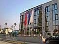
The city of East Sarajevo is the administrative, industrial, commercial, financial and cultural center of the eastern part of Republika Srpska. The position of East Sarajevo is strategically important, located near the biggest city of Bosnia and Herzegovina, City of Sarajevo. East Sarajevo is easily accessible, having an airport close to the city- Sarajevo International Airport and being a point of intersection of numerous roads.[6][7]
Tourism
Jahorina is one of the highest mountains of the Dinaric system. Jahorina mountain range is 30 kilometers long, with several peaks, of which the highest peak Ogorjelica is 1916 meters above sea level. From Sarajevo is 28, from Banja Luka, 200, of Belgrade 320, and 350 kilometers from Zagreb.
With the international airport in Sarajevo Jahorina connects asphalt road, which is regularly held throughout the winter season. The planned construction of a new road from Sarajevo Jahorina over Trebevic.
Industry
East Sarajevo is one of the most important industrial centres in Bosnia and Herzegovina, well known for its companies: Elko, Famos, Energoinvest, Unis and others.[8]
Sport
The local football clubs are Slavija Istočno Sarajevo that plays in the First League of the Republika Srpska and Famos Vojkovići that competes in the Second League of the Republika Srpska.
Basketball Club Slavija is a basketball club from the City of East Sarajevo that competes in the National Championship of Bosnia and Herzegovina.[9]
Also this city is a big volleyball center of Bosnia and Herzegovina. Men club OK Student Pale and women OK Jahorina Pale are competing in highest rank of Bosnia and Herzegovina (Premijer liga) with good results, and OK Mokro Mokro (Pale) and OK Slavija are competing in second rank (First league of Rep. Of Srpska)
The 2019 European Youth Olympic Winter Festival will be held in Sarajevo & Istočno Sarajevo, Bosnia and Herzegovina from 9 to 16 February 2019.
Image gallery
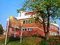 National Theatre
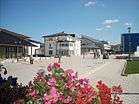
 Institute of books for education
See also
References
- ↑ "City Portal East Sarajevo City". Eastsarajevocity.com. Archived from the original on 2012-02-20. Retrieved 2012-04-06.
- ↑ City of East Sarajevo, Official Web site, History of the city Archived March 16, 2010, at the Wayback Machine.
- ↑ "Trnovo Municipality, Official Website". Trnovo-rs.com. Retrieved 2012-04-06.
- ↑ "Sarajevo, BIH Weather". Weather.msn.com. 1999-12-31. Retrieved 2012-04-06.
- ↑ "POPIS STANOVNIŠTVA, DOMAĆINSTAVA I STANOVA U BOSNI I HERCEGOVINI, 2013. REZULTATI POPISA" (PDF). popis2013.ba (in Serbian). Retrieved 15 December 2016.
- ↑ Business center Archived 2009-08-16 at the Wayback Machine.
- ↑ "Office for security of airport, East Sarajevo". Vasapolicija.ba. Archived from the original on 2012-02-18. Retrieved 2012-04-06.
- ↑ "Famos". Made-in-bosnia.org. Retrieved 2012-04-06.
- ↑ "KK Slavija". Kkslavija.blogger.ba. Archived from the original on 2012-02-19. Retrieved 2012-04-06.
External links
| Wikimedia Commons has media related to Istočno Sarajevo. |
- Turistička organizacija Istočno Sarajevo
- Government of the Republika Srpska
- Portal Istočno Sarajevo - Forum - East Sarajevo City
- Istočno Sarajevo portal
- University of Istočno Sarajevo
- Website of East Sarajevo