Diamond Peak (Idaho)
| Diamond Peak | |
|---|---|
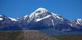 Diamond Peak from Idaho highway 28 | |
| Highest point | |
| Elevation | 12,202 ft (3,719 m) [1] |
| Prominence | 5,377 ft (1,639 m) [2] |
| Listing | |
| Coordinates | 44°08′30″N 113°04′58″W / 44.141667°N 113.082778°WCoordinates: 44°08′30″N 113°04′58″W / 44.141667°N 113.082778°W |
| Geography | |
 Diamond Peak Idaho, U.S. | |
| Location | Butte County, Idaho, U.S. |
| Parent range | Lemhi Range |
| Topo map | USGS Diamond Peak |
| Climbing | |
| First ascent | 1912, T.M. Bannon |
| Easiest route | Scramble, class 3 |
Diamond Peak is the highest point in the Lemhi Range in the Rocky Mountains in Idaho.[3] At 12,202 feet (3,719 m) above sea level, it is the fourth highest peak in Idaho. It is situated 34.5 miles (55.5 km) east of Borah Peak in the Lost River Range, opposite the Little Lost River valley. It is the highest point in the Caribou-Targhee National Forest. The closest higher peak is Mount Church, which is 31.8 mi (51.2 km) to the west.[2]
See also
References
- ↑ "Diamond Peak". NGS data sheet. U.S. National Geodetic Survey. Retrieved October 13, 2012.
- 1 2 "Diamond Peak, Idaho". Peakbagger.com. Retrieved October 13, 2012.
- ↑ "Diamond Peak". Geographic Names Information System. United States Geological Survey. Retrieved October 13, 2012.
External links

This article is issued from
Wikipedia.
The text is licensed under Creative Commons - Attribution - Sharealike.
Additional terms may apply for the media files.