Iron Mountain (Idaho)
| Iron Mountain | |
|---|---|
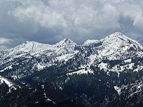 Iron Mountain at right | |
| Highest point | |
| Elevation | 9,694 ft (2,955 m) NAVD 88[1] |
| Prominence | 514 ft (157 m) [2] |
| Coordinates | 43°32′17″N 115°02′41″W / 43.53808°N 115.04486°WCoordinates: 43°32′17″N 115°02′41″W / 43.53808°N 115.04486°W [1] |
| Geography | |
 Iron Mountain | |
| Parent range | Soldier Mountains |
| Topo map | USGS Jumbo Mountain |
| Climbing | |
| Easiest route | Simple Scrambling, class 2 |
Iron Mountain, at 9,694 feet (2,955 m) high is one of the peaks of the Soldier Mountains of Idaho. Iron Mountain is located at the west end of the range northwest of Fairfield in Camas County and Sawtooth National Forest.[3]
While only a class 2 ascent, the primary route up Iron Mountain is 11 miles (18 km) one way. The primary trail to the summit is open to use by two wheel motorized off-road vehicles. An old Forest Service fire lookout can be found on the summit.
The northern slopes of Iron Mountain are drained by Deadwood Creek, a tributary of the South Fork Boise River. Heart Lake is just north-northeast of Iron Mountain while Upper Deadwood Lake is southeast of the peak. Iron Mountain is northwest of Boardman Peak.
References
- 1 2 "Jumbo Mountain". NGS data sheet. U.S. National Geodetic Survey. Retrieved 2012-04-29.
- ↑ Staff. "Iron Mountain". Lists of John. Retrieved 29 May 2012.
- ↑ Sawtooth National Forest. "Sawtooth National Forest" [map].1:126,720, 1"=2 miles. Twin Falls, Idaho: Sawtooth National Forest, United States Forest Service, 1998.
External links
- Fairfield Ranger District trip report
- Sawtooth National Forest - Official Site
- Iron Mountain - Summitpost
This article is issued from
Wikipedia.
The text is licensed under Creative Commons - Attribution - Sharealike.
Additional terms may apply for the media files.