Boundary County, Idaho
Coordinates: 48°47′N 116°27′W / 48.79°N 116.45°W
| Boundary County, Idaho | ||
|---|---|---|
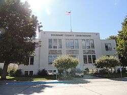 Boundary County Courthouse | ||
| ||
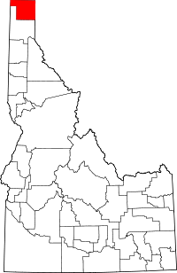 Location in the U.S. state of Idaho | ||
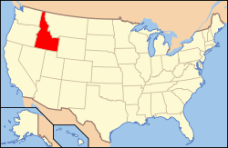 Idaho's location in the U.S. | ||
| Founded | January 23, 1915 | |
| Named for | national border | |
| Seat | Bonners Ferry | |
| Largest city | Bonners Ferry | |
| Area | ||
| • Total | 1,278 sq mi (3,310 km2) | |
| • Land | 1,269 sq mi (3,287 km2) | |
| • Water | 9.3 sq mi (24 km2), 0.7% | |
| Population (est.) | ||
| • (2017) | 11,922 | |
| • Density | 8.6/sq mi (3.3/km2) | |
| Congressional district | 1st | |
| Time zone | Pacific: UTC−8/−7 | |
| Website |
www | |

Boundary County is a county located in the U.S. state of Idaho. As of the 2010 census, the population was 10,972.[1] The county seat and largest city is Bonners Ferry.[2]
Boundary County was created by the Idaho Legislature on January 23, 1915. It is so named because it borders Canada, the only county in Idaho with an international border.
History
Boundary County was formed on January 23, 1915 from Bonner County. It was named Boundary County because it lies on the border of Canada, Washington and Montana.[3]
Boundary County has 7 election precincts: Bonners Ferry, Copeland, Kootenai, Moyie, Naples, North Bonners Ferry, and Valley View. All contain part of Bonners Ferry City except Copeland, Moyie, and Naples precincts.[4][5] Moyie Springs was incorporated in 1947.[6]
Settlement of the area started with the establishment of Bonners Ferry on the Kootenai River in 1864. Settlement was limited to the ferry operation until about 1890. The town of Bonners Ferry was established in 1893. At that point settlement was still sparse with small ranching and mining operations, but an expanding timber economy.[7] By 1900, other areas started to develop with the Boulder (now Kootenai), Boundary (now Copeland), and Naples precincts first listed in the U.S. Census of that year. The Moyie precinct first appeared in the 1910 census.[8][9]
In 1980, convicted spy Christopher John Boyce found refuge in Boundary County, for a few months, after his escape from the Lompoc Federal Correctional Complex. He stayed at the home of Gloria Ann White.[10] Boyce sustained himself during his stay with a series of bank robberies in the surrounding area, allegedly with technical assistance from Ms. White.
In 1992, Boundary County was the scene of the infamous Ruby Ridge siege by 350–400 armed federal agents against Randy Weaver and his family.
In 2018, a plan was put forth for Boundary County, Idaho to secede. The plan released on S.C.O.Y: The Answers Channel calls for turning Boundary County into its own independent country. [11]
Geography
According to the U.S. Census Bureau, the county has a total area of 1,278 square miles (3,310 km2), of which 1,269 square miles (3,290 km2) is land and 9.3 square miles (24 km2) (0.7%) is water.[12]
Boundary County is one of only two counties in the United States to share land borders with 2 states and another country, along with Coös County, New Hampshire.
Adjacent counties
- Lincoln County, Montana – east/Mountain Time Border
- Bonner County – south
- Pend Oreille County, Washington – west
- Regional District of Central Kootenay, British Columbia – north
National protected areas
Transportation
Highways
Airports
Boundary County Airport is a county-owned, public-use airport located two nautical miles (3.7 km) northeast of the central business district of Bonners Ferry.[13]
Demographics
| Historical population | |||
|---|---|---|---|
| Census | Pop. | %± | |
| 1920 | 4,474 | — | |
| 1930 | 4,555 | 1.8% | |
| 1940 | 5,987 | 31.4% | |
| 1950 | 5,908 | −1.3% | |
| 1960 | 5,809 | −1.7% | |
| 1970 | 6,371 | 9.7% | |
| 1980 | 7,289 | 14.4% | |
| 1990 | 8,332 | 14.3% | |
| 2000 | 9,871 | 18.5% | |
| 2010 | 10,972 | 11.2% | |
| Est. 2017 | 11,922 | [14] | 8.7% |
| U.S. Decennial Census[15] 1790–1960[16] 1900–1990[17] 1990–2000[18] 2010–2013[1] | |||
2000 census
As of the census[19] of 2000, there were 9,871 people, 3,707 households, and 2,698 families residing in the county. The population density was 8 people per square mile (3/km²). There were 4,095 housing units at an average density of 3 per square mile (1/km²). The racial makeup of the county was 95.24% White, 0.16% Black or African American, 2.02% Native American, 0.58% Asian, 0.07% Pacific Islander, 0.86% from other races, and 1.07% from two or more races. 3.39% of the population were Hispanic or Latino of any race. 21.4% were of German, 12.9% American, 12.7% English, 9.9% Irish and 6.4% Norwegian ancestry according to Census 2000.
There were 3,707 households out of which 34.10% had children under the age of 18 living with them, 61.40% were married couples living together, 7.50% had a female householder with no husband present, and 27.20% were non-families. 23.10% of all households were made up of individuals and 8.50% had someone living alone who was 65 years of age or older. The average household size was 2.61 and the average family size was 3.07.
In the county, the population was spread out with 29.20% under the age of 18, 6.90% from 18 to 24, 24.40% from 25 to 44, 26.20% from 45 to 64, and 13.40% who were 65 years of age or older. The median age was 38 years. For every 100 females there were 101.40 males. For every 100 females age 18 and over, there were 100.60 males.
The median income for a household in the county was $31,250, and the median income for a family was $36,440. Males had a median income of $31,209 versus $18,682 for females. The per capita income for the county was $14,636. About 11.50% of families and 20% of the population were below the poverty line, including 19.50% of those under age 18 and 11.40% of those age 65 or over.
2010 census
As of the 2010 United States Census, there were 10,972 people, 4,421 households, and 2,976 families residing in the county.[20] The population density was 8.6 inhabitants per square mile (3.3/km2). There were 5,175 housing units at an average density of 4.1 per square mile (1.6/km2).[21] The racial makeup of the county was 94.8% white, 1.7% American Indian, 0.6% Asian, 0.3% black or African American, 0.1% Pacific islander, 0.5% from other races, and 2.1% from two or more races. Those of Hispanic or Latino origin made up 3.7% of the population.[20] In terms of ancestry, 22.5% were German, 12.8% were English, 11.2% were Irish, 7.4% were American, 5.9% were Norwegian, 5.4% were Dutch, and 5.1% were Scottish.[22]
Of the 4,421 households, 29.7% had children under the age of 18 living with them, 55.0% were married couples living together, 7.6% had a female householder with no husband present, 32.7% were non-families, and 27.5% of all households were made up of individuals. The average household size was 2.47 and the average family size was 3.00. The median age was 42.8 years.[20]
The median income for a household in the county was $37,712 and the median income for a family was $43,562. Males had a median income of $36,125 versus $26,076 for females. The per capita income for the county was $18,011. About 15.7% of families and 18.8% of the population were below the poverty line, including 22.0% of those under age 18 and 13.4% of those age 65 or over.[23]
Politics
| Year | Republican | Democratic | Third parties |
|---|---|---|---|
| 2016 | 73.4% 3,789 | 18.1% 933 | 8.6% 441 |
| 2012 | 69.1% 3,138 | 27.0% 1,225 | 4.0% 181 |
| 2008 | 65.0% 3,078 | 31.4% 1,484 | 3.6% 172 |
| 2004 | 68.8% 3,012 | 29.0% 1,268 | 2.3% 99 |
| 2000 | 72.0% 2,797 | 21.4% 832 | 6.6% 255 |
| 1996 | 50.1% 1,937 | 30.9% 1,194 | 19.1% 739 |
| 1992 | 39.2% 1,479 | 29.0% 1,095 | 31.8% 1,200 |
| 1988 | 56.2% 1,800 | 41.7% 1,336 | 2.1% 66 |
| 1984 | 63.5% 2,159 | 34.0% 1,158 | 2.5% 85 |
| 1980 | 59.4% 2,088 | 30.9% 1,087 | 9.6% 338 |
| 1976 | 52.2% 1,458 | 43.5% 1,217 | 4.3% 121 |
| 1972 | 59.3% 1,587 | 32.1% 860 | 8.6% 231 |
| 1968 | 47.2% 1,084 | 38.4% 883 | 14.4% 330 |
| 1964 | 42.9% 1,065 | 57.1% 1,418 | |
| 1960 | 45.2% 1,237 | 54.8% 1,501 | |
| 1956 | 55.2% 1,419 | 44.8% 1,150 | |
| 1952 | 61.0% 1,641 | 38.7% 1,040 | 0.4% 10 |
| 1948 | 43.4% 910 | 49.0% 1,029 | 7.6% 160 |
| 1944 | 49.3% 1,064 | 48.8% 1,053 | 2.0% 43 |
| 1940 | 45.5% 1,221 | 51.9% 1,393 | 2.6% 70 |
| 1936 | 33.9% 732 | 60.3% 1,304 | 5.8% 126 |
| 1932 | 33.4% 763 | 63.4% 1,451 | 3.2% 74 |
| 1928 | 61.7% 1,015 | 36.9% 607 | 1.5% 24 |
| 1924 | 47.0% 829 | 39.2% 692 | 13.8% 244 |
| 1920 | 62.7% 883 | 37.3% 525 | |
| 1916 | 44.1% 598 | 48.1% 653 | 7.8% 106 |
Media
Television
In addition to a local translator district which provides broadcast television stations from Spokane, WA MSA, several additional television broadcast construction permits have been granted by the FCC; among those are K140U-D http://www.bonnersferrynews.com/k14ou-dtv-channel-14-bonners-ferry-id-boundary-county-broadcast-television-channel-14/ and K38NO-D http://www.bonnersferrynews.com/k38no-dtv-channel-38-bonners-ferry-id-boundary-county-broadcast-television-channel-38/.
Radio
Bonners Ferry has been home to KBFI AM 1450 since 1983. It is owned by local licensee Radio Bonners Ferry, Inc, owned by Blue Sky Broadcasting, Inc. While licensed to Bonner's Ferry and its transmitter site is there, KBFI shares studios and offices with its sister stations (KSPT, KIBR, and KPND), at 327 Marion Avenue in Sandpoint, Idaho.
Bonners Ferry is home to 98.3 KAXY-LP, a low power FM radio station operated by Boundary County Community Television, a 501(c)(3) non profit organization. http://bonnersferrynews.com/broadcast-radio/
Newspapers
Bonners Ferry is served by a single newspaper and several online news outlets. The weekly Bonners Ferry Herald, owned by Hagadone Publishing is the official paper of record. The Bonners Ferry Herald website is: http://www.bonnersferryherald.com Former print publication The FlatLander News Magazine and Program Guide now online only http://www.bonnersferrynews.com. Former editors of the Kootenai Valley Times now operate online only at https://kootenaivalleytimes.com.
Communities
Cities
Unincorporated communities
- Copeland
- Eastport
- Good Grief
- Naples
- Porthill
- Curley Creek
See also
- National Register of Historic Places listings in Boundary County, Idaho
- Robert Lindsey, The Flight of the Falcon: The True Story of the Escape and Manhunt for America's Most Wanted Spy, Simon & Schuster, 1983, ISBN 0-671-45159-6
References
- 1 2 "State & County QuickFacts". United States Census Bureau. Retrieved June 28, 2014.
- ↑ "Find a County". National Association of Counties. Archived from the original on 2011-05-31. Retrieved 2011-06-07.
- ↑ Idaho Atlas of Historical County Boundaries. Chicago: The Newberry Library. 2010. p. 62. Retrieved 2 February 2017.
- ↑ "P.L. 94-171 VTD/SLD REFERENCE MAP (2010 CENSUS): Boundary County, ID" (PDF). United States Census Bureau. United States Census Bureau. Retrieved 2 February 2017.
- ↑ "Boundary County, Idaho voting districts". US Census Bureau. US Census Bureau. Retrieved 2 February 2017.
- ↑ A Report of the Seventeenth Decennial Census of the United States Census of Population: 1950. Washington: United States Government Printing Office. 1952. pp. 12–14. Retrieved 2 February 2017.
- ↑ "Bonners Ferry, Idaho". BonnersFerry.com. Retrieved 2 February 2017.
- ↑ Census Reports Volume I: Twelfth Census of the United States taken in the year 1900. Washington: United States Census Office. 1901. p. 112. Retrieved 2 February 2017.
- ↑ Sixteenth Census of the United States: 1940. Washington: United States Government Printing Office. 1942. p. 272. Retrieved 2 February 2017.
- ↑ "Boundary County, Idaho, News".
- ↑ https://www.youtube.com/watch?v=ZbMmCkxjlv4
- ↑ "US Gazetteer files: 2010, 2000, and 1990". United States Census Bureau. 2011-02-12. Retrieved 2011-04-23.
- ↑ FAA Airport Master Record for 65S (Form 5010 PDF). Federal Aviation Administration. Effective 3 June 2010.
- ↑ "Population and Housing Unit Estimates". Retrieved Apr 7, 2018.
- ↑ "U.S. Decennial Census". United States Census Bureau. Archived from the original on May 12, 2015. Retrieved June 28, 2014.
- ↑ "Historical Census Browser". University of Virginia Library. Retrieved June 28, 2014.
- ↑ "Population of Counties by Decennial Census: 1900 to 1990". United States Census Bureau. Retrieved June 28, 2014.
- ↑ "Census 2000 PHC-T-4. Ranking Tables for Counties: 1990 and 2000" (PDF). United States Census Bureau. Retrieved June 28, 2014.
- ↑ "American FactFinder". United States Census Bureau. Archived from the original on 2013-09-11. Retrieved 2008-01-31.
- 1 2 3 "DP-1 Profile of General Population and Housing Characteristics: 2010 Demographic Profile Data". United States Census Bureau. Retrieved 2016-01-04.
- ↑ "Population, Housing Units, Area, and Density: 2010 – County". United States Census Bureau. Retrieved 2016-01-04.
- ↑ "DP02 SELECTED SOCIAL CHARACTERISTICS IN THE UNITED STATES – 2006–2010 American Community Survey 5-Year Estimates". United States Census Bureau. Retrieved 2016-01-04.
- ↑ "DP03 SELECTED ECONOMIC CHARACTERISTICS – 2006–2010 American Community Survey 5-Year Estimates". United States Census Bureau. Retrieved 2016-01-04.
- ↑ Leip, David. "Dave Leip's Atlas of U.S. Presidential Elections". uselectionatlas.org. Retrieved 2018-04-04.
External links
- Boundary County website
- Bonners Ferry
- Boundary County Airport
- Live Webcamera in Boundary County
- Boundary County news
Places adjacent to Boundary County, Idaho | |
|---|---|
Municipalities and communities of Boundary County, Idaho, United States | ||
|---|---|---|
| Cities | ||
| Unincorporated communities | ||