McGown Peak
| McGown Peak | |
|---|---|
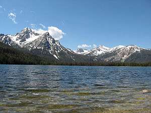 McGown Peak and Stanley Lake | |
| Highest point | |
| Elevation | 9,860 ft (3,010 m) |
| Prominence | 1,100 ft (340 m) [1] |
| Parent peak | Alpine Peak |
| Coordinates | 44°12′48″N 115°04′51″W / 44.2132397°N 115.0809242°WCoordinates: 44°12′48″N 115°04′51″W / 44.2132397°N 115.0809242°W [2] |
| Geography | |
 McGown Peak Custer County, Idaho, U.S. | |
| Parent range | Sawtooth Range |
| Topo map | USGS Stanley Lake |
| Climbing | |
| Easiest route | Scrambling, class 3 |
McGown Peak, at 9,860 feet (3,010 m) above sea level is a peak in the Sawtooth Range of Idaho. The peak is located in the Sawtooth Wilderness of Sawtooth National Recreation Area in Custer County. The peak is located 3.25 mi (5.23 km) north-northwest of Alpine Peak, its line parent. McGown Peak rises above the southwest end of Stanley Lake.[3][4][5]
References
- ↑ "McGown Peak, Idaho". Peakbagger.com. Retrieved January 4, 2013.
- ↑ "McGown Peak". Geographic Names Information System. United States Geological Survey. Retrieved January 4, 2013.
- ↑ Sawtooth National Forest (Map) (1998 ed.). Sawtooth National Forest, U.S. Forest Service.
- ↑ "McGown Peak". SummitPost.org. Retrieved January 4, 2013.
- ↑ "McGown Peak". Lists of John. Retrieved January 4, 2013.
This article is issued from
Wikipedia.
The text is licensed under Creative Commons - Attribution - Sharealike.
Additional terms may apply for the media files.