Backdrop Peak
| Backdrop Peak | |
|---|---|
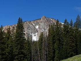 Backdrop Peak from the Baker Lake Trail | |
| Highest point | |
| Elevation | 10,099 ft (3,078 m) [1] |
| Prominence | 639 ft (195 m) [1] |
| Coordinates | 43°41′20″N 114°41′12″W / 43.6889°N 114.6868°WCoordinates: 43°41′20″N 114°41′12″W / 43.6889°N 114.6868°W [1] |
| Geography | |
| Parent range | Smoky Mountains |
| Topo map | USGS Baker Peak |
| Climbing | |
| Easiest route | Scramble, class 3 |

Backdrop Peak, at 10,099 feet (3,078 m) above sea level is a peak in the Smoky Mountains of Idaho. Located in Sawtooth National Forest on the border of Blaine and Camas counties, Backdrop Peak is about 1.45 miles (2,330 m) north of Baker Peak. Baker Lake is just east of the peak.[2][3]
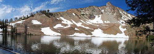
Backdrop Peak and Baker Lake
References
- 1 2 3 "Backdrop Peak". ListsOfJohn.com. Retrieved 2013-01-14.
- ↑ Sawtooth National Forest (Map) (1998 ed.). Sawtooth National Forest, U.S. Forest Service.
|access-date=requires|url=(help) - ↑ "Backdrop Peak". SummitPost.org. Retrieved December 19, 2012.
This article is issued from
Wikipedia.
The text is licensed under Creative Commons - Attribution - Sharealike.
Additional terms may apply for the media files.