Ada County, Idaho
| Ada County, Idaho | ||
|---|---|---|
| County | ||
| Ada County | ||
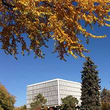 James A. McClure Federal Building and U.S. Courthouse in Boise, Idaho. | ||
| ||
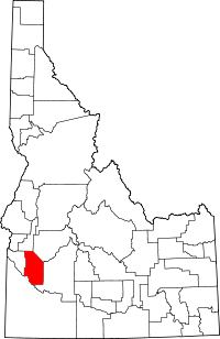 Location in the U.S. state of Idaho | ||
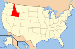 Idaho's location in the U.S. | ||
| Founded | December 22, 1864 | |
| Named for | Ada Riggs, first pioneer child born in county | |
| Seat | Boise | |
| Largest city | Boise | |
| Area | ||
| • Total | 1,060 sq mi (2,745 km2) | |
| • Land | 1,053 sq mi (2,727 km2) | |
| • Water | 7.9 sq mi (20 km2), 0.7% | |
| Population (est.) | ||
| • (2017) | 456,849[1] | |
| • Density | 434/sq mi (168/km2) | |
| Congressional districts | 1st, 2nd | |
| Time zone | Mountain: UTC−7/−6 | |
| Website |
www | |
|
Footnotes: County Code: 1A | ||

Ada County is a county in the southwestern part of the U.S. state of Idaho. As of the 2010 Census, the county had a population of 392,365,[2] making it the most populous county in Idaho with 23.3% of the state's total population in 2010. The county seat and largest city is Boise,[3] which is also the state capital.[4]
Ada County is included in the Boise, ID Metropolitan Statistical Area.
Ada County is by far the state's largest in population, containing just under one quarter of the state's residents, and contains its only county highway district. The Ada County Highway District (ACHD) has jurisdiction over all the local county and city streets, except for private roads and state roads. In the interior Northwest east of the Cascade Range, Ada County ranks second in population behind only Spokane County, Washington.
History
Ada County was created by the Idaho Territorial Legislature on December 22, 1864, partitioned from Boise County. It is named for Ada Riggs, the daughter of H.C. Riggs, a member of the legislature; he established the county and was a co-founder of Boise.[5] Canyon County, which originally included Payette County and most of Gem County, was partitioned from western Ada County in 1891.
Geography
According to the U.S. Census Bureau, the county has a total area of 1,060 square miles (2,700 km2), of which 1,053 square miles (2,730 km2) is land and 7.9 square miles (20 km2) (0.7%) is water.[6] The Boise River flows through the northern portion of the county, and the northwest border is bounded by the foothills of the Boise Range mountains, the summits are in adjacent Boise County. The southwestern border of the county is bounded by the Snake River.
Adjacent counties
- Boise County - northeast
- Elmore County - east
- Owyhee County - south
- Canyon County - west
- Gem County - northwest
Major highways


County roads and highways are maintained by the Ada County Highway District (ACHD).
National protected areas
Demographics
| Historical population | |||
|---|---|---|---|
| Census | Pop. | %± | |
| 1870 | 2,675 | — | |
| 1880 | 4,674 | 74.7% | |
| 1890 | 8,368 | 79.0% | |
| 1900 | 11,559 | 38.1% | |
| 1910 | 29,088 | 151.6% | |
| 1920 | 35,213 | 21.1% | |
| 1930 | 37,925 | 7.7% | |
| 1940 | 50,401 | 32.9% | |
| 1950 | 70,649 | 40.2% | |
| 1960 | 93,460 | 32.3% | |
| 1970 | 112,230 | 20.1% | |
| 1980 | 173,036 | 54.2% | |
| 1990 | 205,775 | 18.9% | |
| 2000 | 300,904 | 46.2% | |
| 2010 | 392,365 | 30.4% | |
| Est. 2017 | 456,849 | [7] | 16.4% |
| U.S. Decennial Census[8] 1790-1960[9] 1900-1990[10] 1990-2000[11] 2010-2013[2] | |||
2000 census
As of the census[12] of 2000, there were 300,904 people, 113,408 households, and 77,344 families residing in the county. The population density was 285/mi² (110/km²). There were 118,516 housing units at an average density of 112/mi² (43/km²). The racial makeup of the county was 92.86% White, 0.65% Black or African American, 0.69% Native American, 1.74% Asian, 0.15% Pacific Islander, 1.67% from other races, and 2.24% from two or more races. Hispanic or Latino of any race were 4.48% of the population.
There were 113,408 households out of which 36.20% had children under the age of 18 living with them, 55.10% were married couples living together, 9.40% had a female householder with no husband present, and 31.80% were non-families. 23.80% of all households were made up of individuals and 6.07% had someone living alone who was 65 years of age or older. The average household size was 2.59 and the average family size was 3.11.
In the county, the population was spread out with 27.30% under the age of 18, 10.30% from 18 to 24, 32.50% from 25 to 44, 20.80% from 45 to 64, and 9.10% who were 65 years of age or older. The median age was 33 years. For every 100 females, there were 100.6 males. For every 100 females age 18 and over, there were 98.9 males.
The median income for a household in the county was $46,140, and the median income for a family was $54,416. Males had a median income of $37,867 versus $26,453 for females. The per capita income for the county was $22,519. About 5.40% of families and 7.70% of the population were below the poverty line, including 9.20% of those under age 18 and 5.70% of those age 65 or over.
2010 census
As of the 2010 United States Census, there were 392,365 people, 148,445 households, and 99,282 families residing in the county.[13] The population density was 372.8 inhabitants per square mile (143.9/km2). There were 159,471 housing units at an average density of 151.5 per square mile (58.5/km2).[14] The racial makeup of the county was 90.3% white, 2.4% Asian, 1.1% black or African American, 0.7% American Indian, 0.2% Pacific islander, 2.4% from other races, and 2.8% from two or more races. Those of Hispanic or Latino origin made up 7.1% of the population.[13] In terms of ancestry, 19.4% were German, 15.9% were English, 11.8% were Irish, and 8.6% were American.[15]
Of the 148,445 households, 35.6% had children under the age of 18 living with them, 52.4% were married couples living together, 10.0% had a female householder with no husband present, 33.1% were non-families, and 25.0% of all households were made up of individuals. The average household size was 2.58 and the average family size was 3.11. The median age was 34.8 years.[13]
The median income for a household in the county was $55,835 and the median income for a family was $67,519. Males had a median income of $48,290 versus $34,875 for females. The per capita income for the county was $27,915. About 6.9% of families and 10.2% of the population were below the poverty line, including 11.8% of those under age 18 and 6.8% of those age 65 or over.[16]
2016
In terms of ancestry, 18.2% were English, 17.6% were German, 9.7% were Irish, 5.7% were American, 3.6% were Norwegian, 3.4% were Italian, 3.4% were Scottish, 2.8% were Swedish, 2.4%French, 2.0% were Dutch, 1.7% were Polish, 1.6% were Danish and 1.3% were Welsh.[17]
Government and politics
Ada County has traditionally been a Republican Party stronghold. The last victory in a presidential election by a Democrat in Ada County was by Franklin D. Roosevelt in 1936 - the last time a Democrat carried the state of Idaho was Lyndon B. Johnson in 1964.[18] In 2008 the presidential election in Ada County was more competitive than in previous years; John McCain defeated Barack Obama by six percentage points.[19]
Democratic gubernatorial nominee Jerry Brady carried the county in his 2002 and 2006 races, despite losing statewide in both contests.[20][21] Another prominent Democrat, Boise mayor David H. Bieter, was reelected in 2007, 2011 and 2015.[22][23]
In the Idaho Legislature, Ada County is split between nine districts, the most of any county.[24] In the state house, Republicans hold ten seats and Democrats hold eight. In the state senate, Republicans hold five seats and Democrats hold four. Generally, Democratic strength is concentrated in Boise itself, while Republican strength is concentrated in the western suburbs.[25] Several of the Boise seats were Democratic pickups in 2006.[26]
Each party held all of their respective legislative seats the 2008 elections, but Republicans won two competitive county commission races.[27]
| Year | Republican | Democratic | Third parties |
|---|---|---|---|
| 2016 | 47.9% 93,752 | 38.7% 75,677 | 13.4% 26,240 |
| 2012 | 53.5% 97,554 | 42.3% 77,137 | 4.2% 7,555 |
| 2008 | 51.6% 93,328 | 45.5% 82,236 | 2.9% 5,196 |
| 2004 | 61.1% 94,641 | 37.8% 58,523 | 1.2% 1,866 |
| 2000 | 60.8% 75,050 | 32.9% 40,650 | 6.3% 7,785 |
| 1996 | 52.5% 61,811 | 36.6% 43,040 | 11.0% 12,892 |
| 1992 | 44.5% 49,000 | 29.0% 31,941 | 26.5% 29,225 |
| 1988 | 62.9% 54,951 | 35.0% 30,525 | 2.1% 1,858 |
| 1984 | 72.4% 60,036 | 26.2% 21,760 | 1.4% 1,128 |
| 1980 | 63.8% 55,205 | 24.6% 21,324 | 11.6% 10,015 |
| 1976 | 64.4% 41,135 | 33.1% 21,125 | 2.6% 1,629 |
| 1972 | 67.5% 36,665 | 23.4% 12,687 | 9.1% 4,959 |
| 1968 | 63.0% 30,185 | 24.1% 11,529 | 12.9% 6,167 |
| 1964 | 56.4% 25,404 | 43.6% 19,639 | |
| 1960 | 62.0% 27,703 | 38.1% 17,017 | |
| 1956 | 70.0% 26,387 | 30.0% 11,328 | |
| 1952 | 72.7% 27,415 | 27.2% 10,281 | 0.1% 40 |
| 1948 | 56.1% 14,972 | 42.1% 11,253 | 1.8% 480 |
| 1944 | 55.5% 13,410 | 44.2% 10,667 | 0.3% 67 |
| 1940 | 50.9% 12,861 | 49.0% 12,381 | 0.2% 51 |
| 1936 | 36.9% 7,581 | 58.5% 12,027 | 4.7% 966 |
| 1932 | 46.0% 8,055 | 50.4% 8,836 | 3.6% 631 |
| 1928 | 71.8% 10,279 | 27.4% 3,921 | 0.8% 108 |
| 1924 | 54.5% 7,220 | 28.5% 3,780 | 17.0% 2,255 |
| 1920 | 66.7% 8,419 | 33.1% 4,173 | 0.2% 27 |
| 1916 | 48.3% 5,299 | 47.5% 5,207 | 4.2% 460 |
| 1912 | 32.0% 3,198 | 25.7% 2,569 | 42.3% 4,227 |
| 1908 | 53.1% 4,778 | 41.3% 3,721 | 5.6% 503 |
| 1904 | 69.5% 4,536 | 22.5% 1,466 | 8.0% 524 |
| 1900 | 56.6% 2,706 | 43.4% 2,072 |
County Offices
Similar to other Idaho counties, an elected three-member county commission heads the county government. Other elected officials include clerk, treasurer, sheriff, assessor, coroner, and prosecutor.[29]
| Office | Office Holder | Party | |
|---|---|---|---|
| Assessor [30] | Robert H. McQuade | Republican | |
| Clerk of the Circuit Court [31] | Christopher D. Rich | Republican | |
| County Commissioner District 1 [32] | Jim Tibbs | Republican | |
| County Commissioner District 2 [33] | Rick Visser | Republican | |
| County Commissioner District 3 [34] | David L. Case | Republican | |
| Coroner [35] | Dotti Owens | Democrat | |
| Prosecutor [36] | Jan M. Bennetts | Republican | |
| Sheriff [37] | Steve Bartlett | Republican | |
| Treasurer [38] | Vicky O. McIntyre | Republican | |
The Idaho Department of Correction operates the South Boise Prison Complex,[39] a correctional facility located in unincorporated Ada County, south of the Boise Airport and east of Kuna.[40]
Education
Public school districts
Communities
Cities
Census-designated place
See also
References
- ↑ "American FactFinder". U.S. Census Bureau. March 23, 2018. Retrieved March 23, 2018.
- 1 2 "State & County QuickFacts". United States Census Bureau. Archived from the original on July 6, 2011. Retrieved June 28, 2014.
- ↑ "Find a County". National Association of Counties. Archived from the original on 2011-05-31. Retrieved 2011-06-07.
- ↑ Idaho Department of Commerce (2011). "Facts About Idaho". Idaho Department of Commerce. Archived from the original on 2011-09-03. Retrieved 2011-11-10.
- ↑ "Ada County". Retrieved 28 August 2017.
- ↑ "US Gazetteer files: 2010, 2000, and 1990". United States Census Bureau. 2011-02-12. Retrieved 2011-04-23.
- ↑ "American FactFinder". Retrieved March 23, 2018.
- ↑ "U.S. Decennial Census". United States Census Bureau. Archived from the original on May 12, 2015. Retrieved June 28, 2014.
- ↑ "Historical Census Browser". University of Virginia Library. Retrieved June 28, 2014.
- ↑ "Population of Counties by Decennial Census: 1900 to 1990". United States Census Bureau. Retrieved June 28, 2014.
- ↑ "Census 2000 PHC-T-4. Ranking Tables for Counties: 1990 and 2000" (PDF). United States Census Bureau. Retrieved June 28, 2014.
- ↑ "American FactFinder". United States Census Bureau. Archived from the original on 2013-09-11. Retrieved 2008-01-31.
- 1 2 3 "DP-1 Profile of General Population and Housing Characteristics: 2010 Demographic Profile Data". United States Census Bureau. Retrieved 2015-12-30.
- ↑ "Population, Housing Units, Area, and Density: 2010 - County". United States Census Bureau. Retrieved 2015-12-30.
- ↑ "DP02 SELECTED SOCIAL CHARACTERISTICS IN THE UNITED STATES – 2006-2010 American Community Survey 5-Year Estimates". United States Census Bureau. Retrieved 2015-12-30.
- ↑ "DP03 SELECTED ECONOMIC CHARACTERISTICS – 2006-2010 American Community Survey 5-Year Estimates". United States Census Bureau. Retrieved 2015-12-30.
- ↑ https://factfinder.census.gov/bkmk/table/1.0/en/ACS/16_5YR/DP02/0500000US16001
- ↑ "1964 Presidential General Election Results - Idaho". Retrieved 2 January 2018.
- ↑ 2008 - General Election Ada County Archived March 21, 2015, at the Wayback Machine.
- ↑ November 5, 2002 General Election Results Archived August 27, 2008, at the Wayback Machine.
- ↑ November 7, 2006 General Election Results Archived August 27, 2008, at the Wayback Machine.
- ↑ Bieter beats Tibbs in Boise mayor race Archived 2011-07-14 at the Wayback Machine.
- ↑ "Archived copy". Archived from the original on 2016-03-04. Retrieved 2016-01-07.
- ↑ Idaho Legislative District Map Archived 2011-11-17 at the Wayback Machine.
- ↑ "Idaho Legislative Districts". Archived from the original on 10 November 2008. Retrieved 2 January 2018.
- ↑ "Baseline 08: Idaho Legislature". Ridenbaugh Press. Retrieved 2 January 2018.
- ↑ "Election shows GOP still has the edge in Ada County". Retrieved 2 January 2018.
- ↑ Leip, David. "Dave Leip's Atlas of U.S. Presidential Elections". Uselectionatlas.org. Retrieved 2 January 2018.
- ↑ "Ada County". Adaweb.net. Retrieved 2 January 2018.
- ↑ "Assessor". Adacounty.id.gov. Retrieved 2 January 2018.
- ↑ "Ada County Clerk Auditor Recorder > Home". Adacounty.id.gov. Retrieved 2 January 2018.
- ↑ "Jim Tibbs, Dist. 1". Adacounty.id.gov. Retrieved 2 January 2018.
- ↑ "Rick Visser, Dist. 2". Adacounty.id.gov. Retrieved 2 January 2018.
- ↑ "David L. Case, Dist. 3". Adacounty.id.gov. Retrieved 2 January 2018.
- ↑ "Coroner". Adacounty.id.gov. Retrieved 2 January 2018.
- ↑ "Ada County Prosecutor". Adacounty.id.gov. Retrieved 2 January 2018.
- ↑ "Ada County Sheriff > Home". Adasheriff.org. Retrieved 2 January 2018.
- ↑ "Treasurer". Adacounty.id.gov. Retrieved 2 January 2018.
- ↑ "Information Technology Projects." Idaho Department of Correction. March 2011. Retrieved on June 3, 2011.
- ↑ "Locations." Idaho Department of Correction. Retrieved on June 4, 2011. Kuna area addresses: "South Idaho Correctional Institution Community Work Center (CWC) 14195 S. Pleasant Valley Road Kuna ID 83634" "Correctional Alternative Placement Program (CAPP) 15505 S. Pleasant Valley Rd. Kuna ID 83634" "Idaho Correctional Center (ICC) 14601 S. Pleasant Valley Rd Kuna ID 83634" "Idaho Maximum Security Institution (IMSI) 13400 S. Pleasant Valley Rd Kuna ID 83634" "Idaho State Correctional Institution (ISCI) 13500 S. Pleasant Valley Rd Kuna ID 83634" "South Boise Women's Correctional Center (SBWCC) 13200 S. Pleasant Valley Rd. Kuna ID 83634" "South Idaho Correctional Institution (SICI) 13900 S. Pleasant Valley Rd Kuna ID 83634"
Further reading
- "Ada County". State website. Archived from the original on 2005-11-26. Retrieved 2005-09-20.
External links
Places adjacent to Ada County, Idaho | ||||||||||
|---|---|---|---|---|---|---|---|---|---|---|
| ||||||||||
Municipalities and communities of Ada County, Idaho, United States | ||
|---|---|---|
| Cities | ||
| CDP | ||